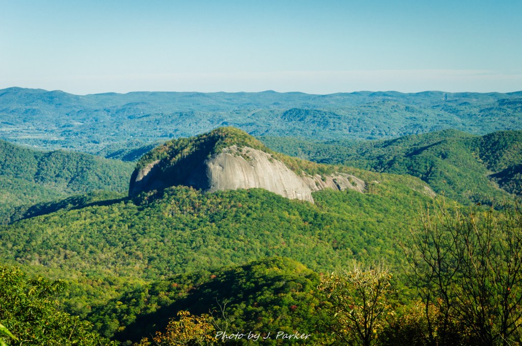
I felt like I was walking on air. I knew I wasn’t – in fact I was hiking on the narrow ridge of Tennent Mountain, part of the Great Balsams some distance west of Asheville along the Blue Ridge Parkway. There was but a narrow path that navigated the small bit of the ridge that remained level enough at the top to walk. In many areas the terrain sloped quickly and someone steeply on either side, but still mild enough to provide just the right level of unobstructed views and excitement without the feeling of danger. Straight ahead, one could see far enough to see the distinctive, somewhat flat (from far away at least) crest of the Black Mountains, tallest mountains east of the Mississippi (I hadn’t yet realized how many places this immensely imposing mountains were visible from). To our right, one could see the opposite ridgeline being ridden by the Blue Ridge Parkway, whose image of a road through the sky was perhaps no better exemplified than this stretch of road. Beyond that, one could see the distinctive ball of Looking Glass Rock, though very small and far, far below (some 1,500-2000 feet lower in elevation gain). We had hiked that rock yesterday, and it was hard to imagine one could find a location so dramatically higher, but there we were, looking down on the rock which had struck fear into us at the end, where the dramatic slope of the rock gave us little comfortable place to enjoy the views we had hiked over 3 miles to obtain.
Today was different. Tennent Mountain, and Black Balsam before it (we had crossed its distinctive peak with 360 degree panoramic views first) were far more up our alley. I had dreamed of this. I had imagined a place where I felt like I was walking in the clouds, a dramatic view to be found in every direction, beautiful parts of the world far below, just like the shaft and balls of Looking Glass Rock was now. I hadn’t known where I would find it, but in the months previously, when sometimes I had been in so much pain from my injured hip that I was confined to bed for entire three day weekends, I had romanticized the moment I would someday obtain in my head. I had longed for that place every day as I literally worked through pain, not knowing when or if I would get better, not knowing if I would have to have surgery, and not even knowing what was actually wrong with my hip. I had written a song about it, called “Up On A Mountain”, which had a pretty lyric and melody line which wasn’t done justice by the rush recording I had made. This was the moment I had waited for. This was the thing that made all the months of pain, both physically and emotionally, at least make sense.
Many people consider the Black Balsam area a great hike. It is. For me, it was more than just that. It was a life moment. It was reward for my suffering, and it was the world’s way of telling me that sometimes things don’t work out the way you had planned, but sometimes the trials in life cause you to end up somewhere maybe even better than what you had planned. Had things gone well, I would have visited the Smokies in July that year. Things didn’t after my hip injury. I would have truly enjoyed myself in the Smokies, but I had at least had a brief visit there before. Had I taken that trip, I may have never explored these other parts of southern Appalachia, places that have a virtue all their own and have become some of my favorite in the world.
Black Balsam wasn’t our first or last stop that day, but it was the most important. We had begun the day cruising forest road 475B, which becomes a rather rustic path on its path through the Pisgah National Forest after placing important places like the trailhead for Looking Glass Rock. Owing to our harrowing experience at Darnell Creek Road, a one lane road in Georgia where we nearly lost traction and slid off the road, we didn’t enter the forest road without some preliminary research assuring ourselves that we wouldn’t find ourselves over our head again. The road was fine, and in fact was quite a joy to cruise in these early fall days, where its winding path providing a good view of the forest and its changing color.
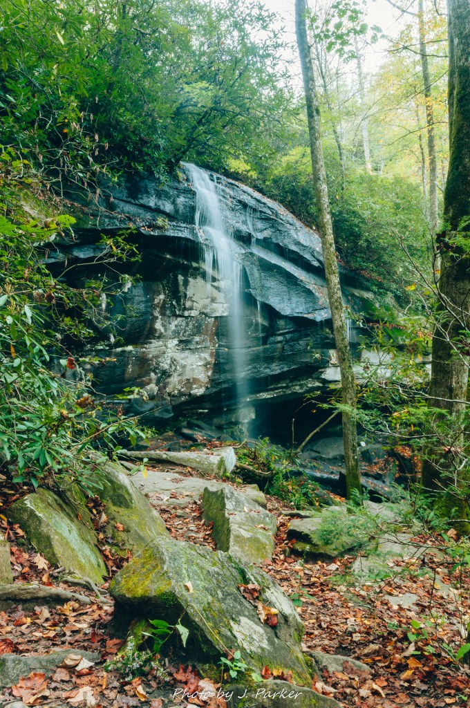
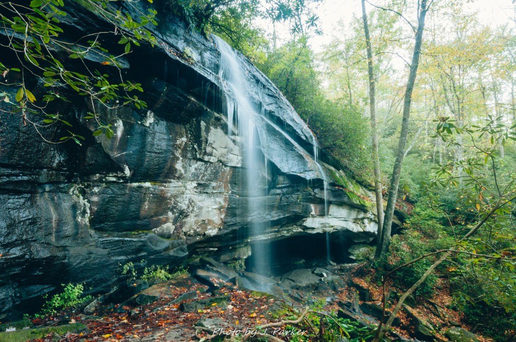
Our first stop along 475B was Slick Rock Falls, a narrow waterfall visible from the roadway which we reached shortly after dawn. We had set out early for a variety of reasons, not the least of which that is was going to be an intensely sunny day, and I wanted to get at least one good shot of a waterfall before light became too difficult. Slick Rock Falls was maybe 100 yards walk from the roadway, and the trail practically crossed its based on its way to the base of Looking Glass Rock I believe. With a narrow flow plunging over a wide rock face, it shared some similarities with Moore Cove Falls, whose nearby location we had visited the day before, though this one lacked the wide cave of Moore Cove. With the plentiful amount of moisture that emanated from the fall and its spray, there was an abundant amount of green to be found surrounding the fall. Photographing it was a simple matter, with the terrain and access dictating the angle. We enjoyed this fall and quickly moved along the roadway.
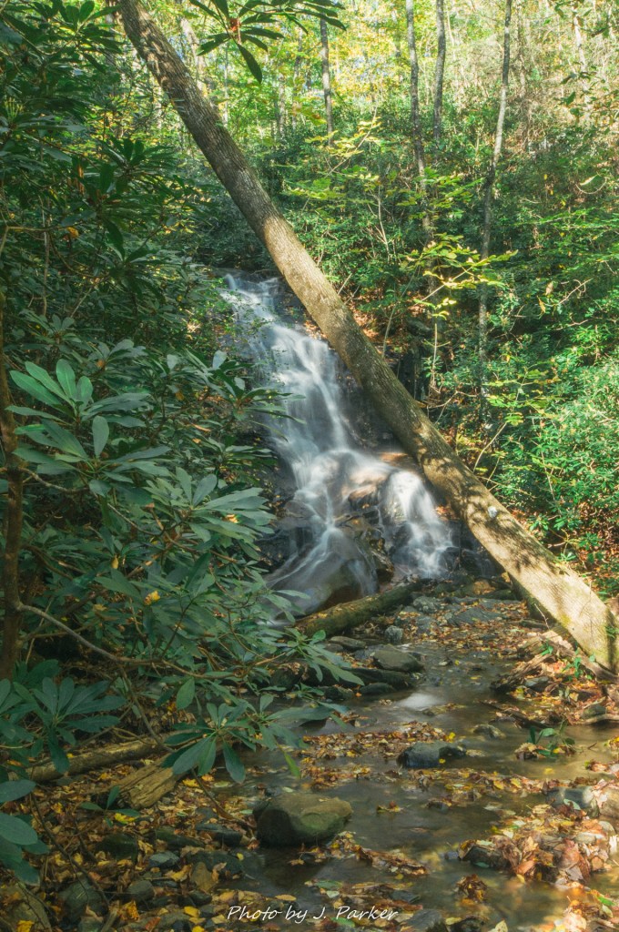
We planned to spend more time at our second stop, where we were going to hike a foot-traffic only forest road with access to 3 or 4 waterfalls. This low-key trail is rather off the beaten path but popular with knowledgeable waterfalls seekers. I was excited to do a little bit of backwoods waterfall seeking myself, but nnfortunately, I found myself not enjoying this trek all that much. The hike was along a forest road which is, well….a forest road. They are rarely the most exciting of hikes and this certainly fit the ball. But more significant than that, the weather was just all wrong for waterfall seeking. There was not a cloud in the sky, which made photographing the waterfalls well a near impossibility, and waterfalls rarely show their best in intense sunlight. We made it to the first waterfall, Log Hollow Falls, where I made a half-hearted attempt to photograph it, and made it to a second fall a short distance away, but I just wasn’t into it. We started following a goat path to a third fall, Discovery Falls, which in the right weather is quite impressive. But partway down the path, I decided to turn back. Not because of any difficulty, I just wasn’t feeling it. I had thought this waterfall hike might end up rewarding, it wasn’t feeling so, and at this point I cared nothing more than to make sure we saved enough time to thoroughly enjoy Black Balsam Knob.
We cruised the rest of forest road 475B until it joined US 276 a few miles north, enjoying a few peaks through the trees which allowed a fleeting glimpse of Looking Glass Rock, a treat since we had hiked the rock the day before without ever having a glimpse of the shape of the rock from far away. US 276 heading back towards Brevard providing even better views of Looking Glass Rock. I chastised myself for not running the GoPro at this point – it would have been a great chance to take a great shot of the roadway which could be sped up later to make a fun scenic video. The Pisgah was teeming with an energy that just seemed to emanate from the trees and the creekbeds. The forest filling with color was a joy just to drive through, and my views from the road were more satisfying than what I had gotten on the Log Hollow Falls hike.
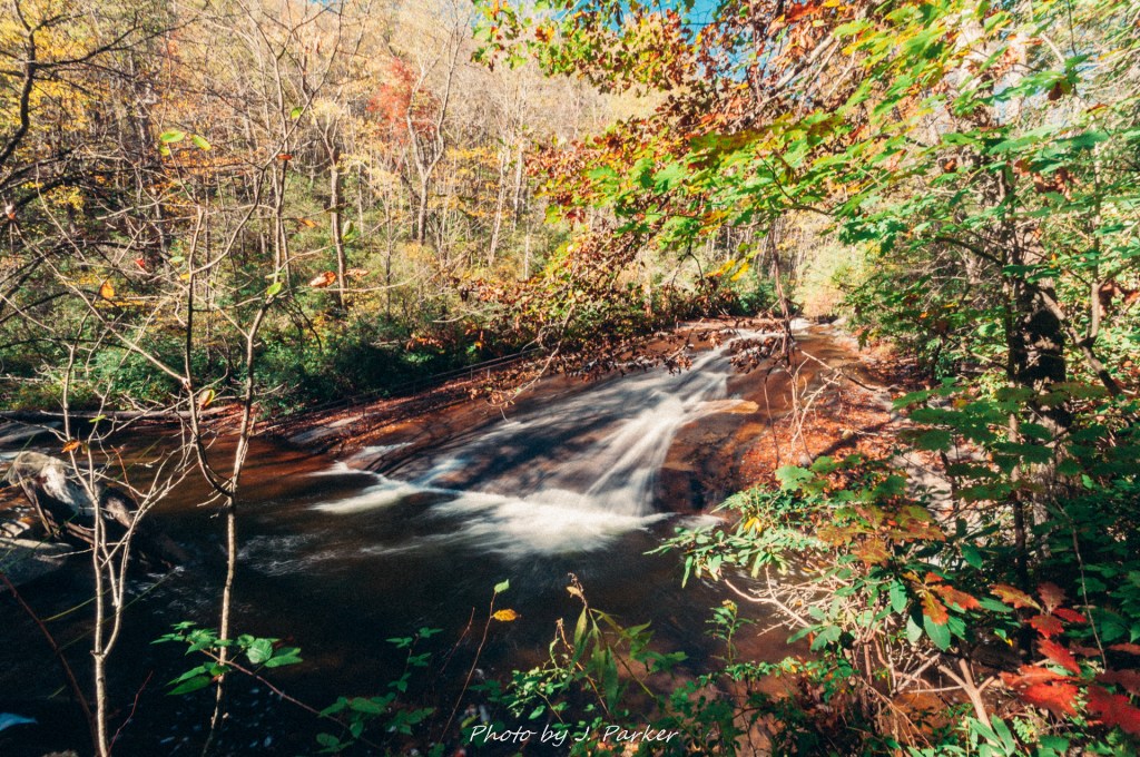
Along this stretch of US 276 is Sliding Rock, a waterfall known for its use in the warm months for providing a rather large natural water slide. Dozens wait in line to partake in this water attraction during summer, but visiting in the fall meant nobody would be partaking in the water that day. It had a romantic feel with the mix of colors in this part of the forest, and it was the rare waterfall that could be photographed evenly in the midday sun. Since we hadn’t spent as much time hiking at Log Hollow Falls as envisioned, we were able to relax a bit at Sliding Rock. Its angled crescent shape was enjoyable to admire in person, and while I enjoyed attempted to photograph its moderate flow, Jess enjoyed walking the rock around the scenic creek as it flowed downstream from the waterfall. Despite the lackluster hike, being able to visit two waterfalls and enjoy the woods of the Pisgah lit up in seasonal color made the morning very worthwhile.
We weren’t going to head to Black Balsam just yet – part of the reason why we had hung around that area of the Pisgah is that there weren’t exactly many food options had we headed right towards the Blue Ridge Parkway. After some days on a long trip in 2015 where we had been unable to locate restaurants, and now wanting to miss meals as we needed to sustain energy through a week+ of hiking, we stayed in close enough proximity to Brevard to return for lunch. The fun started as we returned northward on US 276, repeating sections of roadway we had traversed two or three times already, but this time planning to take it all the way to the Blue Ridge Parkway. Two things climbed dramatically in conjunction with each – the elevation of the roadway as it began to climb, climb, climb, and my excitement levels, both for the hike I eagerly anticipated as well as just returning to the Blue Ridge Parkway, which held a lot of sentimental value for me, having taken a three day journey on it to cap off our honeymoon six years before. On that trip we had cruised almost the length of it from north to south, which understated its prominence above the surrounding territory. Climbing from Brevard on US 276 got the point across a lot more clearly – we were gonna be very, very high up. At a certain point the roadway was a nearly continuous climb, which necessitated a fairly serpentine course as one neared the Parkway. I can’t be sure, but I think there may have been a vertical loop just before the finish line.
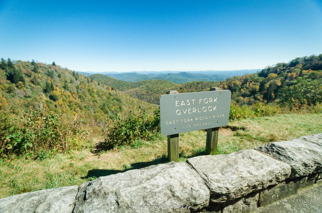
I made sure to run the GoPro for this portion of the drive, not repeating my mistake from the morning. Unfortunately, going this direction on US276 didn’t afford the same scenic views as the morning. Upon reaching the Blue Ridge Parkway, scenic views were to be had, but we were driving directly into the sun, which made the video a washed out, imperceptible mess. But that was spilled milk not worth crying about – we were enjoying in person the wondrous experience of being 1,000 feet or more above much of the surrounding terrain. I got nostalgic as we ventured past familiar places we had enjoyed on our honeymoon – Looking Glass Overlook, Graveyard Fields, etc. – but we kept the vehicle pointed forward, focused on the prize, waving at the multitude of overlooks as we passed, but not allowing ourselves to be distracted by we had been before in lieu of ones we hadn’t visited. There was one overlook – The East Fork Overlook – which we stopped at because we couldn’t recall having seen its impressive view in 2011.
Throughout this blog I’ve probably referred to the area we were headings towards at the time as “Black Balsam”. That’s how I’ve come to think of it and how I believe many people think of it, for Black Balsam is the premier peak in the area and most hikes starting at the parking area are going to take you over, or at least around the base of, Black Balsam. At the time, this was Tennent Mountain to me – that was our primary destination, and for someone who had done a fair amount of preparation for this trip, I was somehow pretty clueless as to why lied ahead (I don’t want to imply I was, or encourage anyone else to be, unprepared. I had plenty of maps and directions to help keep my way). Being an informed hiker, its rare these days that hikes truly surprise me or catch me unaware, but we were blown away almost from the moment we left the parking area under that glorious blue sky, and we had our blissful ignorance to thank for that.
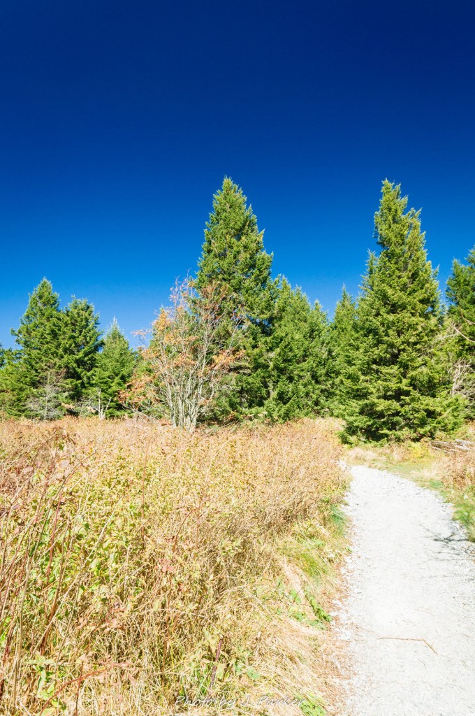
I had an unbridled feeling of excitement as we entered a small patch of evergreen forest – what would be the only true forest we would see on this hike – but I had little idea that the highlights would start a very short distance into the trail. On the other side of the forest, an incline beckoned. Sometimes inclines provide a sense of foreboding. Even ones which lead to an exciting place usually balance that out with the dread of the physical toll. But this incline was open, and most of the terrain around it was open. Two separate subpeaks called out from above, appearing as small breasts stretching into the blue sky (this is important, for I love breasts equally so as mountains). The incline didn’t matter to me. In my head, physical exertion didn’t exist. Excitement overrode every part of my being.
In my head there wasn’t exertion. My body didn’t quite agree, but I cared little to notice. With every small bit of trail I climbed, I had to look back, taking a new picture every time as more and more of the terrain below was revealed. Lo and behold, in realistic terms I could scarcely see that much more than the last time I looked, but that little bit never never seized to amaze me.
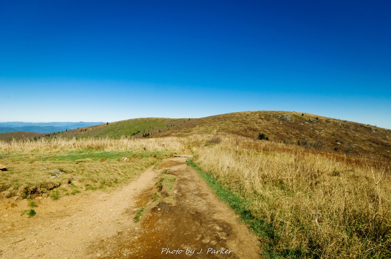
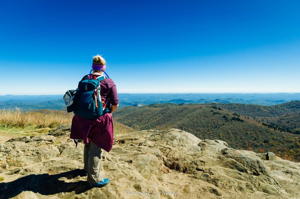
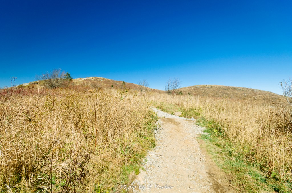
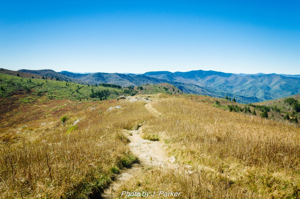
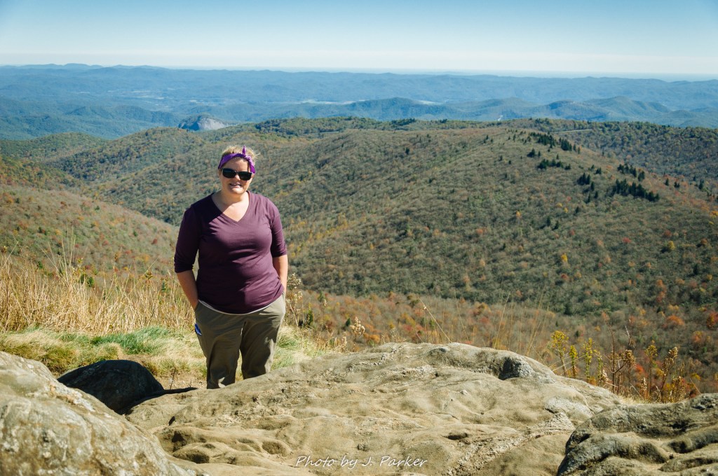
At the top of the incline lied a first sub-peak of this impressive mountain whose name at the time I did not know, but whose name I’ll never forget after this day. Here there was a moderately flat expanse of terrain, with odd rock formations dotting the terrain. At the high elevation of the area, the peak of fall had essentially already come and gone. The grasses were brown, but the openness provided by their dead-appearing state brought life to the area. I had enjoyed mountain vistas before, even some on small balds, but this was something different than I had ever witnessed before. I had visited my share of Appalachian mountains before, but had never been on one that wasn’t predominantly forested. One could glance out and see other ridgelines, many of them being only partially forest as well. What I was seeing made me think of somewhere in California, not Appalachia. I hadn’t been expecting to be taken to another world. I didn’t know where to turn or look, so I recklessly aimed both my DSLR and my GoPro at anything I could find, capturing everything while simultaneously capturing very little. But I had entered a dream whose pictures and video could scarcely hope to reflect my own nostalgia-tinted memories. But just in case pictures could I tasked Jess with the mirrorless camera, whose standard zoom lens could capture opposing ridgelines better than the wide angle on my DSLR could (plus I might get the incidental shot of myself existing, which is hard to obtain when you’re the photographer).
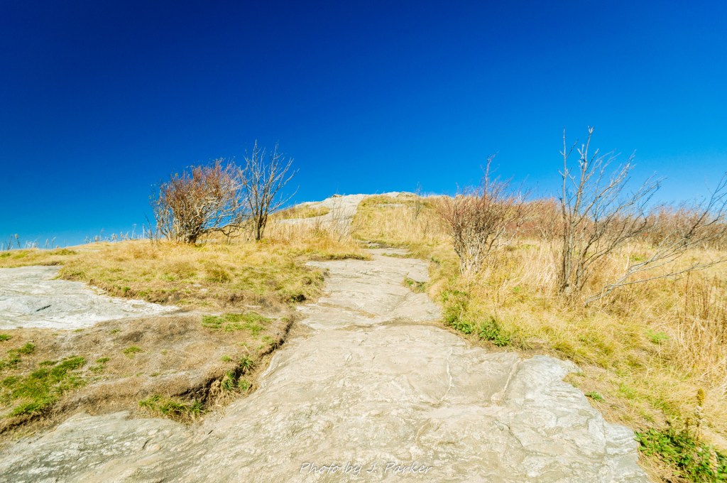
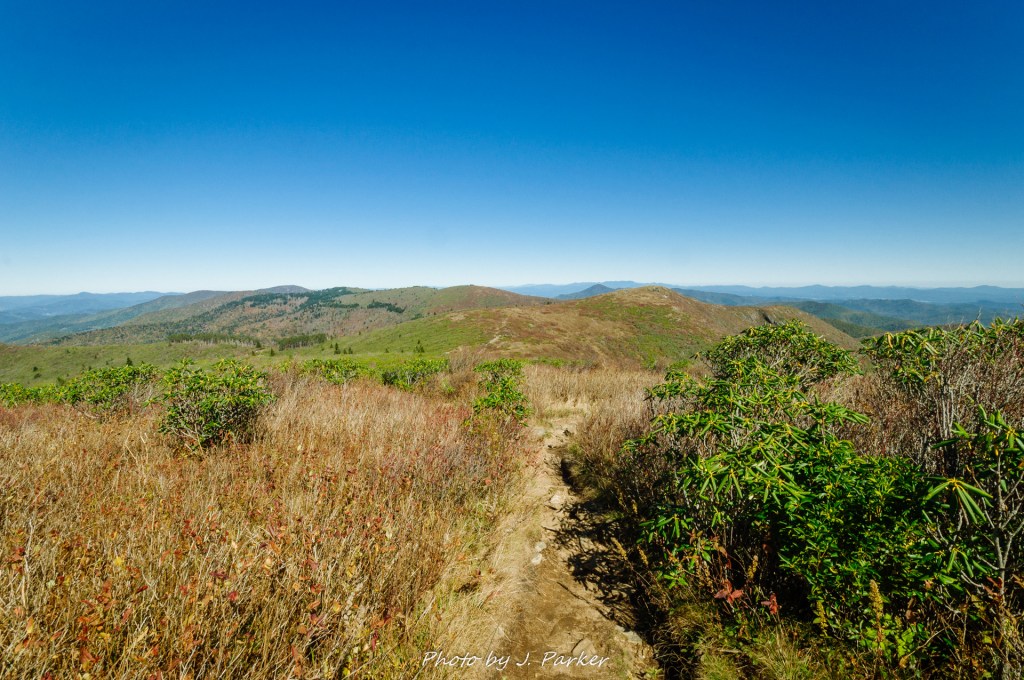
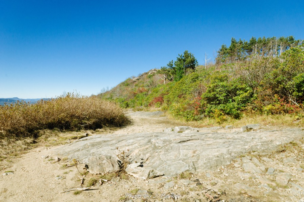
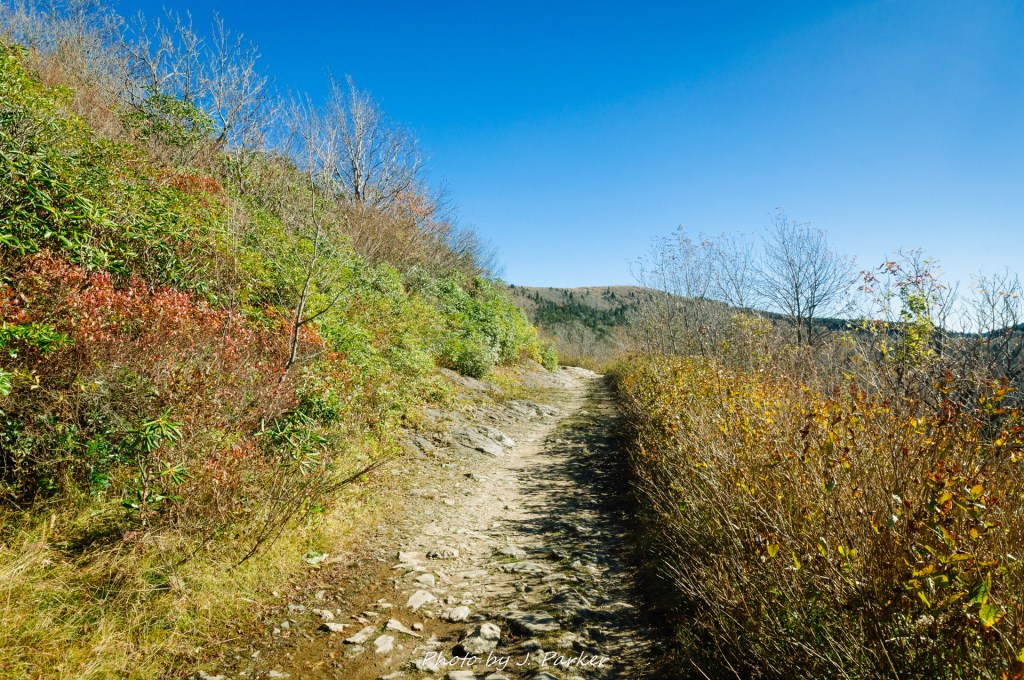
The greatness of the area was already apparent, yet we hadn’t even come close to ascending a single summit – much less Tennent Mountain, the primary destination of our hike. Ahead a stretch of bare rock cut through the grasses marked the path of the trail (finding the path of the trail, which at this point was the Art Loeb and Mountain to Sea Trail, was not a given in this area. The aforementioned trails are blazed white, and there are no trees to blazes, so usually one can only occasionally find a hard to spot white blaze painted on the rocky path which as a whole has a white tint in the sunlight. No need to worry though, as its very hard to get lost with open visibility). In my head I waxed poetically to narrate my Go-Pro video as I documented the thrill of climbing every further; in actuality it was silly emotional drivel that would probably be embarrassing to share with other souls, but after enduring the hardest year of my life I, the man who has decided to blog about the mountains, I’m still at a loss for words to truly summarize what these moments meant for me.
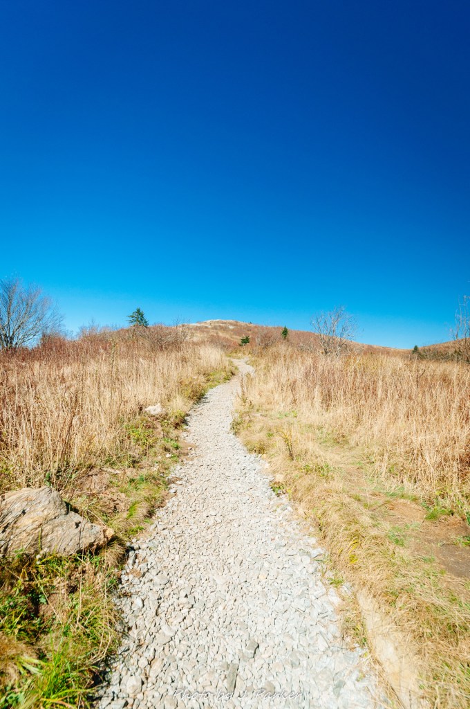
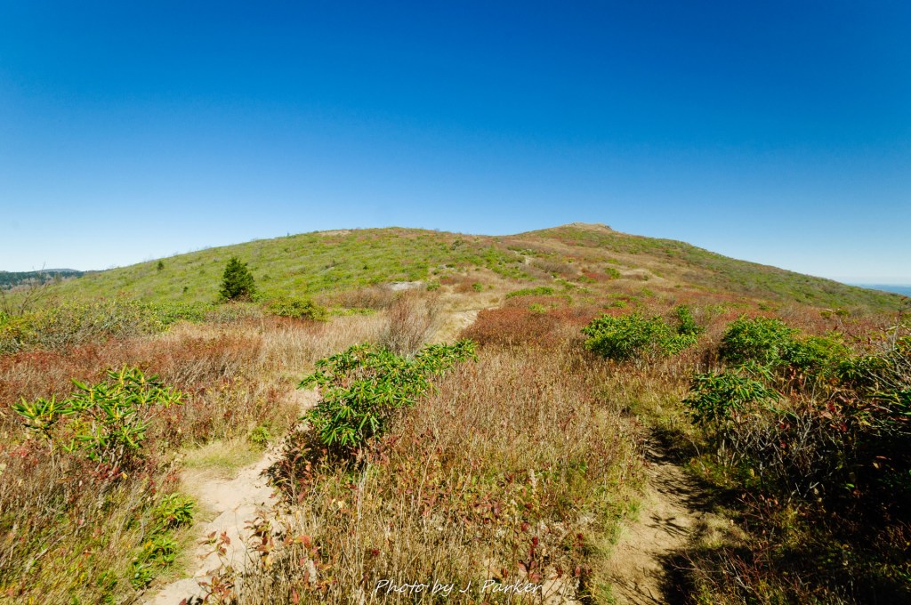
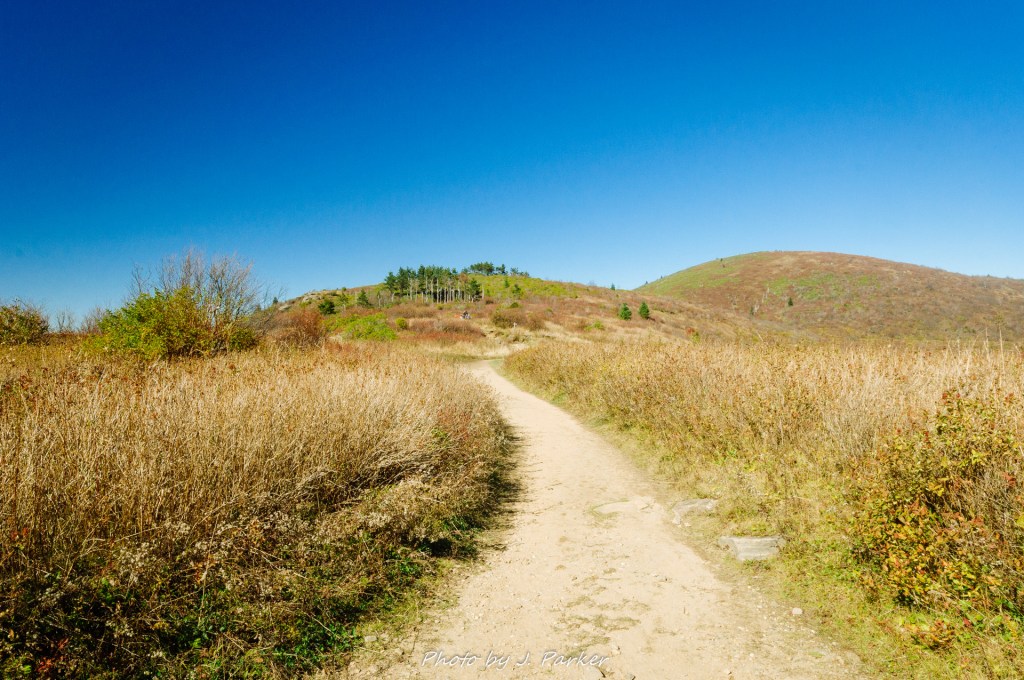
A second sub-peak awaited. We had thought this might be close to the top, but found that we would be going even higher after this. No matter, getting to climb even higher than we already were wasn’t a hindrance, it was a bonus. This sub-peak naturally provided even better views than the first, for we were finally starting to see not just the opposite ridgelines, but starting to get an unfathomably wide view of vast distances. We savored this view for a moment, but a particularly appealing stretch of trail just ahead called to us, as the path gradually curved to work its way towards a date with the summit. I tried to capture this gentle curve repeatedly; in the end I found that the photos served to capture my experience well but didn’t necessarily capture the ambiance for people who hadn’t personally experienced this hike.

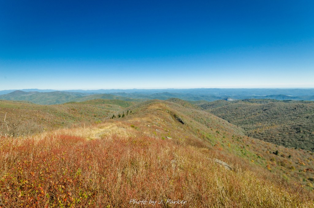
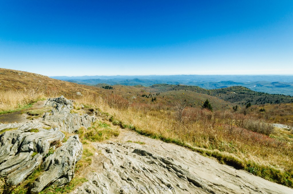
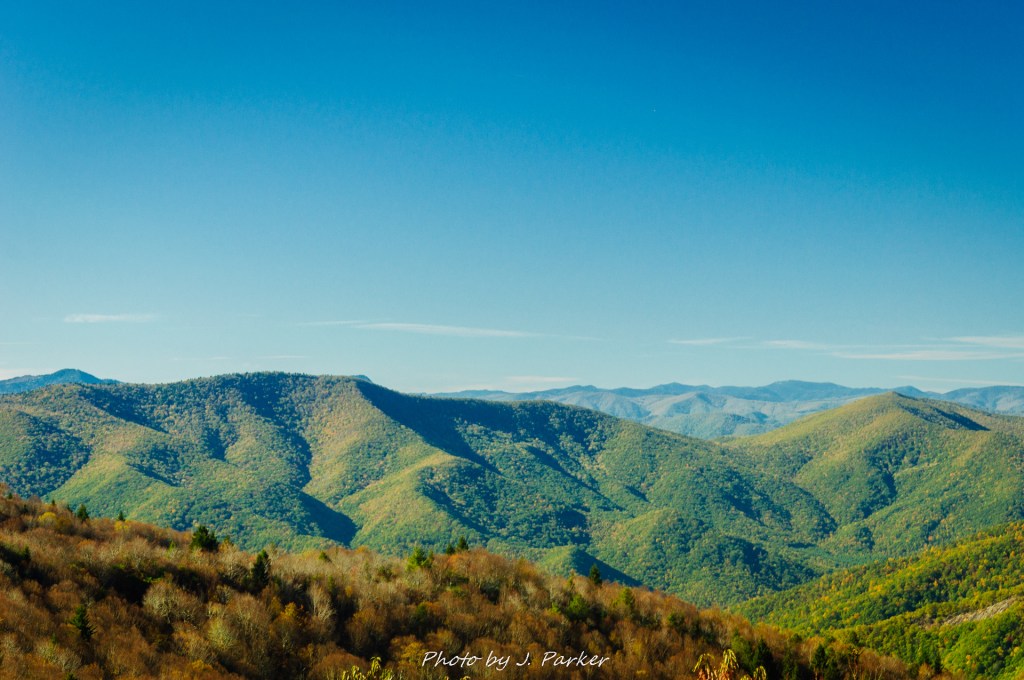
We climbed further into the blue sky to the open expanse ahead, still not aware of the name of this peak but not really particularly caring about names. We were living in the moment, one that I would wish to relive repeatedly. At the top was one of those perfect places in nature, an area where you could walk free and essentially had 360 degree views from a peak which was the highest in the immediate area. Somewhat to the north an unusual rocky ridgeline appeared with a thin top and boulders strewn about its summit. In my own nerdy brain its shape brought to mind a certain Star Wars ship from a video game I had played as a child. Could that ridge be Tennent Mountain, I wondered out loud ? I wasn’t entirely sure we weren’t on Tennent Mountain at the time. I had very little idea of what shape the namesake mountain would have. The odd shape meant of that ridge I had a hard time envisioning its scale or estimating its distance. Whatever it was, it seemed quite exciting, and different than everything surrounding it.
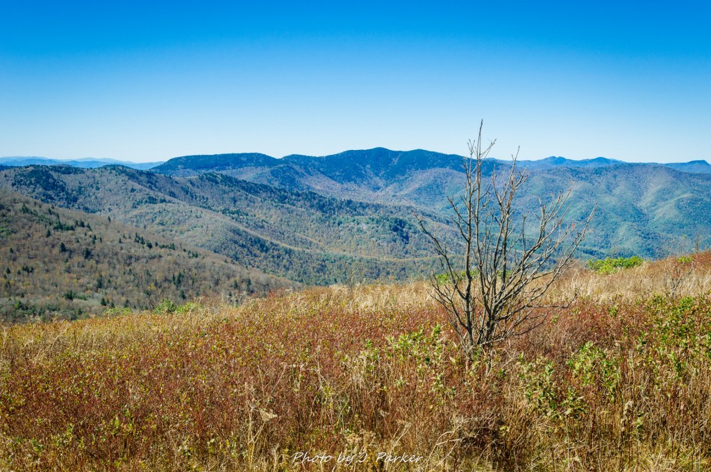
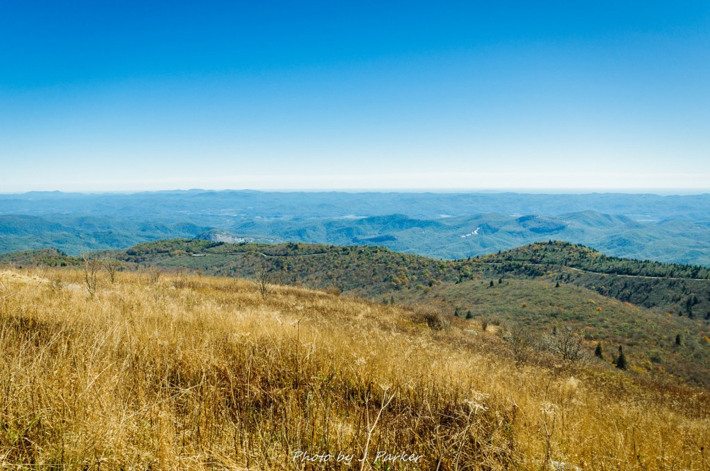
To the east a strong ridgeline rose opposite. To the southwest ran the Blue Ridge Parkway, whose serpentine course appeared even more aesthetic as far more of its course was visible here than previous. Behind it, a big surprise, for Looking Glass Rock could barely be seen. I hadn’t really imagined we would see it during this hike, and I certainly couldn’t have imagined it looking both so small and so low by comparison. The day before we had hike to its summit as the most difficult trek by the numbers we had ever undertaken; now that elevation that we had worried about for months was but a speck on the horizon. This real life comparison was emblematic of how we would perceive the two; ultimately, hiking Looking Glass was just a blip on the horizon, but the hike we were on would dramatically outshine it.
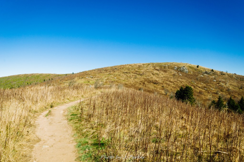
That odd ridge to the northeast was indeed where we would be going. And somebody had informed us while on the top of our current peak, which I was “pretty sure” was Black Balsam, that it was indeed Tennent Mountain ahead. So that was figured out. What wasn’t figured out was where exactly to go from the summit we were on. For some unfathomable reason, the Art Loeb Trail had decided not to visit the summit of Black Balsam, even though it seemed to be on its direct path and its not like the summit was strenuous to reach. We didn’t want to backtrack, and there were a myriad of decent quality paths venturing forward. In fact, the unblazed paths seemed to be more well-trod than the blazed trip, almost as if others couldn’t understand why the trail would bypass the summit either. Not being worried about losing my sense of direction in the open area, we ventured forward on the best path, but that unfortunately lead us into a veritable hell.
Ok, so the path ahead wasn’t that atrocious, but I believe the scientific term for what we were entering was “rhododendron hell”. Tall, thick bushes lined the path on both sides, encroaching on the walking space and obscuring the view of anything but the sky and the tips of the peaks surrounding you. I was thankful that the colder season was suppressing the stinging insects, as with my phobia I would not have found it fun to share that path with wasps and bees. The going was slow as the bushes gripped at our extremities and our bags, and the sometimes sandy path was difficult to see among the brush. We both slipped and feel on our butts at traversing what I dubbed the “tunnel of misery”. Every delay while navigating this veritable maze was frustrating, as I was anxious to get on with reaching the compelling ridge of Tennent Mountain. Ten minutes felt like an hour, but we eventually broke into an open area where we caught the white-blazed Art Loeb Trail again, whose also narrow path still seemed like a boulevard after what we had just experienced.
The trail began climbing again, but it was at a fairly gradual pace, and again my excitement for what lie ahead overrode the physical strain of going uphill. Like Black Balsam, the top of Tennent Mountain did not disappoint either, but it contrasted with its adjoining peak in several ways. Whereas Black Balsam had spaces which were wide and one could freely roam, Tennent was more narrow but more romantic, with rocks ideal for doubling as benches dotting its ridge every so often, allowing a perfect place to sit and rest while enjoying the sweeping view. The view from here wasn’t quite the 360 view of Black Balsam, owing partially to the size of the latter, taller peak in its view, as well as Tennent’s own ridgeline being wide and narrow. The positive though was that the ridge never seized to be an interesting view even while you were on it. It was a joy to trace the faint path marking a serendipitous course along the mountain. Though we were far from along at any point in this hike (save for the tunnel of misery), Tennent had a mere handful of people compared to the masses at the first peak. While Tennent is not a strenuous hike at all, Black Balsam is the type of peak that invites casual visitors to take the short trek off the road to take in its sweeping views without venturing farther. And there’s nothing wrong with that – I’ve been that visitor in other places many times. But it was refreshing for Tennent Mountain to have a comparatively quiet feel.

We struck up conversations with several people as we enjoyed several vantage points. One pointed out the Devil’s Courthouse nearby. I myself was less impressed by that than just the fact that the Devil seems to take a residence or have a room, or in this case a courthouse, at nearly every mountain location. Apparently even the devil has a soft spot for Appalachia. Another gentleman warned us about the mud on the Ivestor Gap Trail; I thanked him for his help but had to inform him that we were from Florida, and as such we’ve rarely encountered a trail that wasn’t mud. At one point I left my camera open and a dandelion drifted in, whose beautiful seeds were going to bring their charm and a special level of dirt to my camera bag. I marveled at what a first world problem it was to have a dandelion in the bag for your expensive camera.
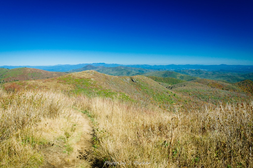
As we worked our way farther east, I was finally sure that a faraway but very tall and wide peak in the distance had to be Mt. Mitchell. I had no idea that the tallest mountain in the east could be viewed from so far a distance, and I’ve continued to be amazed at how many places you can see Mt. Mitchell from at subsequent stops in North Carolina. Mt. Mitchell is almost double the height of Looking Glass Rock; that was apparent when one could take in that magical view along Tennent’s ridgeline. It was interesting to think that we were now hiking along the spine of that ridge that we had spied from Black Balsam, and thankfully the ridge was just as compelling up close.
It was with a bit of sadness that the trail finally reached the end of the ridgeline and began to take a curved slope downwards, completing an elongated 180. This was to be the last time we would be elevated above the surrounding terrain during this hike, though there were still some views to be found. My trail directions warned us that the following descent was going to be a bit steep and rough, and it was almost disappointing to find this stretch of trail had nothing on the tunnel of misery coming down from Black Balsam. We reached an obvious junction with the Ivestor Gap Trail, which we planned to use as the back side of our loop. To our right lay the edge of the Shining Rock Wilderness, and many people continue on to epic hikes in that direction. Well we aren’t that epic, not with me coming off a hip injury, but we did take a peak at the next peak, walking a few hundred yards to see the next rise up close. I enjoyed getting a bit closer view of this area but we had to make it our turnaround point, and we began making our way up the Ivestor Gap Trail in earnest.
One would have thought that with one trail going over two summits and the other being an old road bed over relatively flat terrain that the latter would be much easier to traverse, but the Ivestor Gap Trail was just a slog. It was disappointing to find that it had all the negative of being a forest road, lacking the visuals a single track trail traversing the terrain would have, while its exceptionally rocky path was in some ways harder to traverse than the summit paths we had taken previously. A flat trail that is rocky will make you concentrate on every step to avoid turning an ankle (or in the case of Jess, avoid turning your ankle more than 2-3 times over the course of any given hike), while a path that travels the terrain will at least help your feet more naturally find footing, though that’s easier going uphill than down. Knowing the real highlights of the journey were over, we were just hoping for a quick and easy passage, not a long stretch of trail that would force us to focus with every step.
At least things balanced out a bit by the Ivestor Gap Trail offering a couple surprising views along its path. Its mostly clung to the side of Black Balsam with a strand of brush obscuring your view outward, but the occasional gap in the brush provided a peak at the adjoining ridgelines which was in some ways just as compelling as those found at the summits earlier in the hike. Having expected no views at all, this was a nice bonus.
Hiking as we did, completing the loop involved a short trek up the road to get back to the trailhead we had started at; we completed this without difficulty, and even our little bit of roadwalk was nice. An easy addition to our hike would have been Sam’s Knob, another mountain which can be hiked from the lower trailhead in a relatively short hike; we entertained the idea but I felt a more satisfying use of our time would be to visit Skinny Dip Falls, a waterfall not far off the Blue Ridge Parkway on the way to Asheville where we were staying. It would be getting fairly close to dark by the time we made the drive and short hike to the fall, but this was by design; there would be great photo light at the end of the day. Back we went along the Parkway, and it was another bonus that the parking for this fall was at the Looking Glass Overlook. Having felt cheated by not getting a view of that rock before we hiked to the top the day before, it was great to take in a close view and be like “I tapped that.”
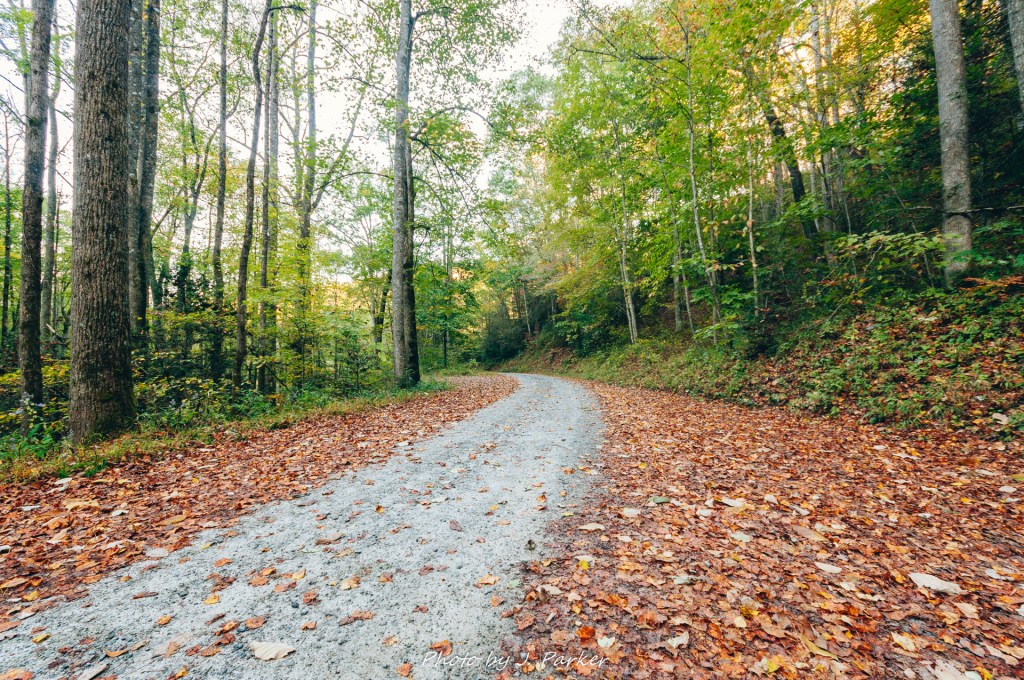
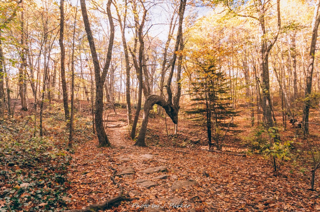
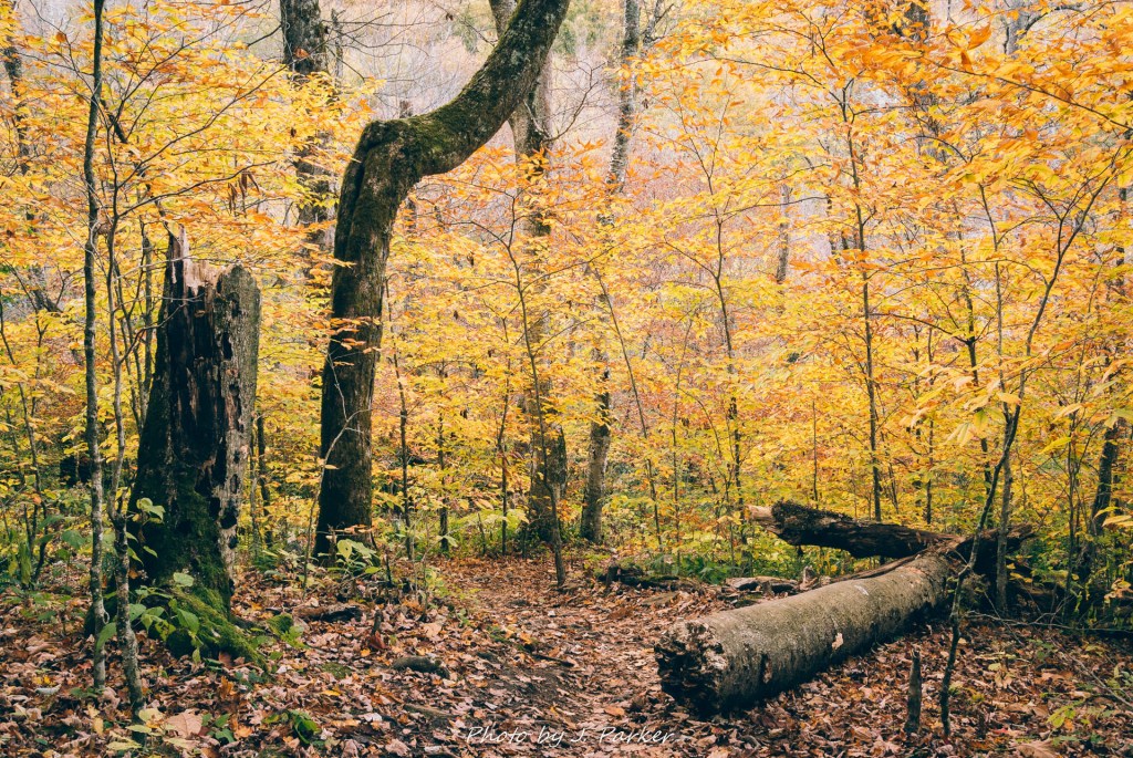
Leaving the Parkway for the woods ushered us into another world almost immediately. The woods were alive with the deepest shades of gold I had ever personally witnessed. Not far into the trail we passed an iconic tree, bent in such a way it was obvious that humans had sculpted it to be a navigation tool.
We reached a trail junction. Not knowing exactly which path to take, I trusted my instinct as to which one would lead to the fall, knowing taking the wrong one would likely leave us without enough daylight to fix the mistake. My instincts seemed correct, for as we ventured farther into these colorful, vibrant woods, we began to hear a mix of running water and people that betrayed the presence of a waterfall. The woods carried such beauty just by themselves that I was aggrieved to have to choose between photographing them or the waterfall; I stuck to the fall, and I was rewarded only a short time later when I reached the flat viewing area which overlooked maybe the most beautiful fall I have personally witnessed. It would be a difficult thing to say flat out that Skinny Dip Falls is the best waterfall I’ve seen. I can simply most accurately say that at this present time I can’t think of a fall I find prettier.
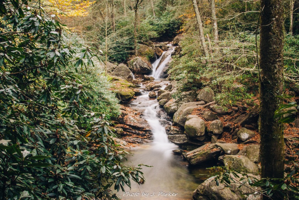
The beauty of the fall hadn’t gone unnoticed by others, either. A crowd of all types of people enjoyed a variety of vantage points, and I was suddenly faced with the potential agony of not being able to photograph the scene in front of me (the shot above wasn’t taken upon first arrival). A mix of fresh woods and cigarette smoke wafted through the air, and I bid my time while trying to find frames devoid of people. What made Skinny Dip special wasn’t just the beauty of one single tier, it was that there were a thousand small points of beauty along its path. Water seemed to flow through its tiers in non-linear fashion, providing compelling bursts of white water flowing between rocks covered in orange leaves. This was the type of scene that I had witnessed on the travel sights and hiking guides, a bit of perfectly timed color surrounding a dreamlike flow of water. Only I was here in person and capturing it myself.
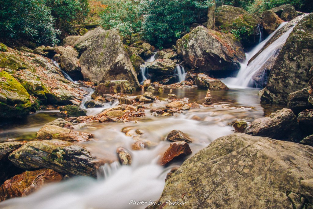
I would have loved to have been the only one at Skinny Dip Falls on that colorful fall day, though I wouldn’t have gotten my nicotene fix from secondhand smoke without others there. Fortunately, I was able to dash before I left the fall, and setup my small mirrorless camera on a moment’s notice when all the people clogging the rocks had to leave to fetch another cigarette at once.
The walk back to the car was just as striking as the walk to the fall. Darkness was approaching, and my camera was ill setup at the time to capture the woods, but I took a few snaps when I could to try and immortalize this pure fall scene. Skinny Dip Falls was a truly perfect end to an awesome day. It had started with a whimper but ended with one of the most enchanting hikes I had ever taken and a bonus stop at an amazingly gorgeous fall. This was exactly what I had come to North Carolina hoping to see, and I felt extremely fulfilled as we made our way towards a planned day of rest in Asheville, where in exploring the city we ended up walking more miles than some of our planned hiking days.
