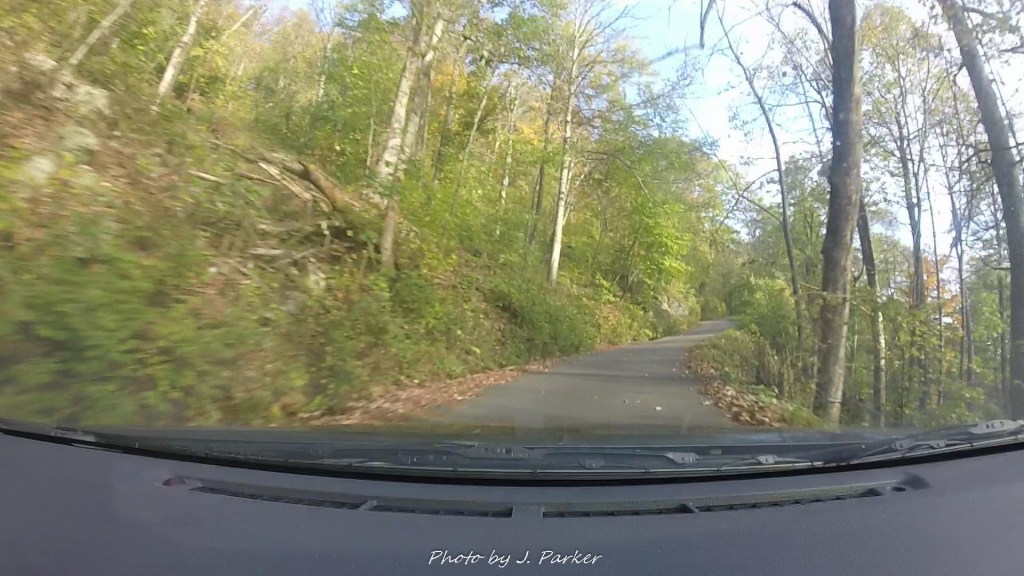
The car flew through the sharply ascending curve, drifting into the other lane in the process before entering another steep ascent, where yet another frightening switchback turn awaited as we navigated the final stretch of a long journey on forest roads to the Table Rock Parking Area on the edge of Linville Gorge. The engine, set in lower gear in attempt to get every bit of power out of a Toyota Corolla definitely out of its element, strained under the assault, though it scarcely strained more than my hands gripping the steering wheel tightly, wondering how much longer this could endure before the road could climb no more. Thankfully at this time in the morning there weren’t any vehicles coming down, for the only way to navigate these turns without risking rolling downhill was to maintain speed through them. Mirrors placed around each corner gave assistance in theory for cars coming opposite directions, but they were of little help. For one, there was little time to break concentration from the road ahead, and two, those mirrors wouldn’t have added traction to our tires or power to our engine if we had to slow to accommodate a vehicle.
“The last mile to the parking area is very steep”, one of several trail guides I referenced had warned. Well, they weren’t joking. At least it wasn’t a dirt path like the one we had nearly lost the vehicle on five days ago in Georgia, though much of the road through the forest had been of the unpaved variety, the serious nature of this ascent mean that after miles of rustic roadway, you suddenly found pavement again. That made the road feel much safer in much the same way that duct tape always provided reassurance when one was on a poorly maintained fair ride.
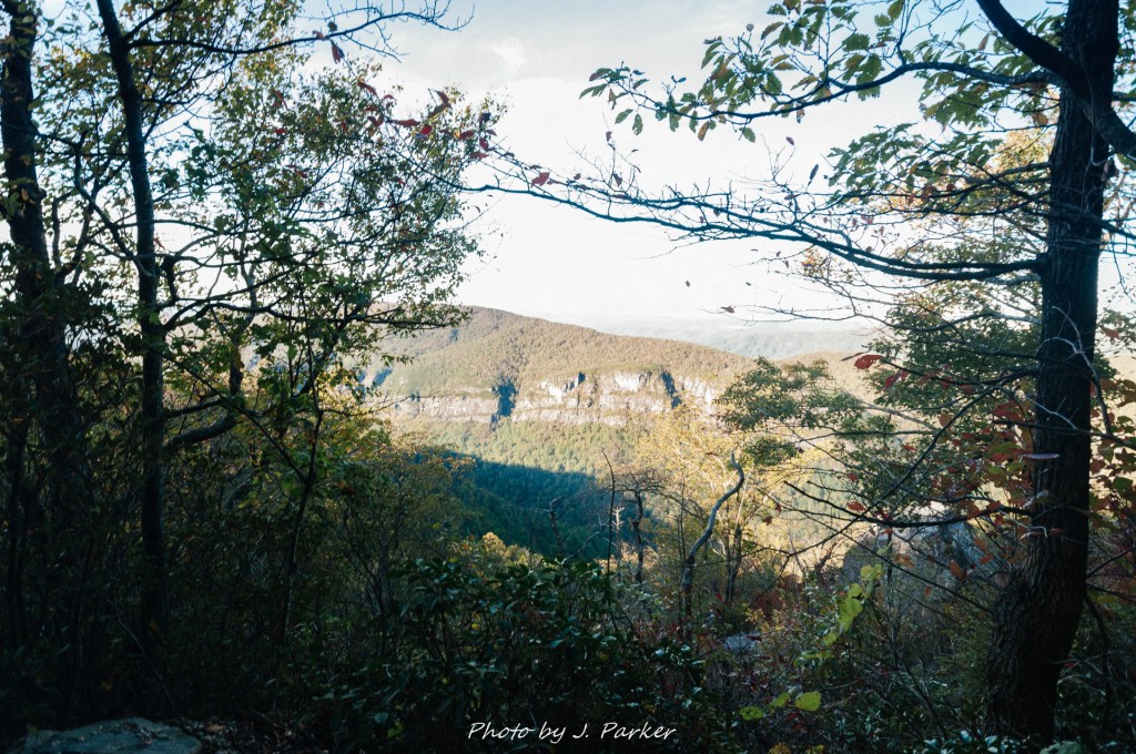
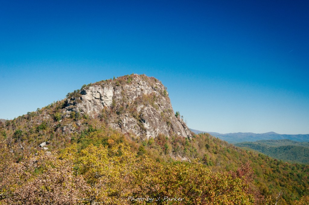
Up we went, through one, two, three, four gosh I don’t know how many frightening switchbacks. Despite my training from the good folks at Sesame Street, my ability to count was disabled when faced with the overwhelming need just to keep my vehicle from plunging off a mountain. I may have caught a glimpse of death hanging out beside the road, on call just in case he happened to be needed, eating a sandwich to store up some injury in case a strenuous extraction was needed. Higher and higher we climbed, but I could pay no heed as I had to give everything I could just steering and providing the appropriate amount of power to a Corolla that I’m not sure was capable of providing the appropriate amount of power. Jess, on the other hand, could clearly make note of the heights we were scaling, a somewhat experience for someone with vertigo. Because of her vertigo I got behind the wheel for roads like this, though I’m not sure its much better being a passenger who has no distraction from the world going by is much better. Had I been more free to notice the scenery going by, I would have taken note of the large, looming white rock face as the impressive rock known as Table Rock visible through gaps in the trees, but I didn’t notice the gaps in the trees. I scarcely noticed the trees.
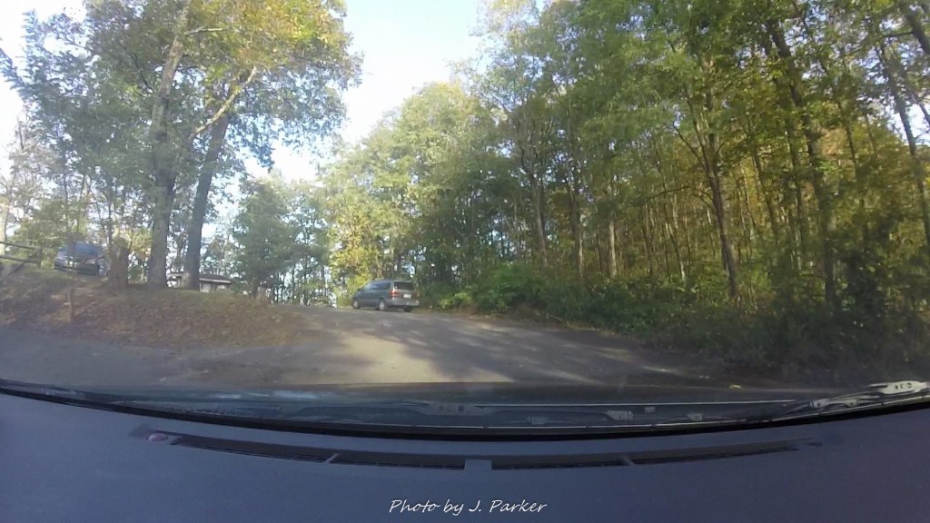
We navigated a quick left turn and I was almost taken off guard when a full fluedged parking area was slowly revealed, almost getting the same feeling one gets when they ride a short but intense rollercoaster, where one hits the break run unexpectedly and finally gets to process the mayhem they had just endured. The parking area, which was none too small, was surprisingly busy. People in North Carolina didn’t screw around when it came to their mountains. I was amazed at how many vehicles had successfully navigated that trek, and since there were no smoking vehicle ruins that we could see off the side of the roadway, apparently everyone who tried it had been successful that day, much to my surprise. Completing the journey was such an accomplishment that I was almost disappointed that there wasn’t a cheering crowd, composed mostly of hot women in bikinis, waiting to bombard me with adoration at the finish line, much like the old video game Cruisin USA. Alas, we would have to be satisfied with the reward of the hike that awaited us at the end of that frightful journey.
Linville Gorge, which we would be hiking along that day, is one of the most foreboding stretches of terrain in the southeast United States. That led to it being mostly untouched even as logging operations spread through the southeast. Reported as the deepest gorge East of the Mississippi (I hesitate to report such things as fact when I’m not 100 percent sure), it had been in competition with the Great Smoky Mountains to become the East’s first national park. While the delegation from Knoxville won that battle, leading to America’s most visited national park, Asheville folk later devoted their energies towards bringing the Blue Ridge Parkway their way. The gorge, another part of absolutely expansive Pisgah National Forest, instead gave birth to the Linville Gorge Wilderness in 1964, the first year of the Wilderness Act. While it’s unparalleled scenery would have made a great national park of its own, in a way its nice that it didn’t, for instead the gorge stays much more under the radar and allows for a more pristine, natural experience which is devoid of the crowds that national park status would bring. (I would also add that the Smoky Mountains are certainly more than worthy of a national park).
Like the casual tourists we were at the time, Jess and I had visited the one popularly accessed area along the gorge in Linville Falls, housed in a popular recreation area along the Blue Ridge Parkway, during our honeymoon in 2011. The falls were such a focal point for us that we actually backtracked some distance to see them the morning after a rainstorm had ended our journey to the falls almost before it started. The falls lying at the top of the gorge are nice but they provide little testament to the true majesty of the gorge. As we gazed at the thundering course of water whose plunge downhill vaguely reminded me of a toiler I got the sense that some greater laid behind me in this “Linville Gorge”, but I had little idea what. It seemed like a place that real nature people would enjoy, but I wasn’t sure we were real nature people. Had I really gained a real view of the gorge from that Parkway trip in 2011 I’m not sure I even would have appreciated it, for the scenic road contains so many easily obtained views that they lose their sense of drama. You hop out of the car, see a sign that says something like “Little Big Angry Duck Mountain”, and you say wow and you move forward to the next view. At any rate, we were looking for a different experience.
On this 2017 trip we were limited to taking our pick of moderate hikes, of which the gorge surprisingly has several signature options. While Shortoff Mountain and Hawksbill Mountain each sounded appealing, the route I chose was one detailed by my friend and skilled mountain explorer Mark Oleg, whose excellent trail guide (https://www.hikingtheappalachians.com/trail-reports/table-rock-the-chimneys-and-nc-wall) provided a detailed outlined for a hike also rated highly by many other outlets. This hike would offer the dual highlight of two spectacular areas on either side of the parking area, first taking the more strenuous path up the round peak of Table Rock before doubling back, crossing the parking area again, and then entering the extremely rugged ridge of The Chimneys on the other side. If we were able to follow the trail guide, we would also have side treks to some notable locations like the Devil’s Cellar (apparently, the devil really likes the Pisgah National Forest, though its hard to blame him) and the Wall, though we would find navigating all these side treks would be a bit above our skill level. The hike was in the five mile range total, and one was never too far from the parking area, something that made me comfortable in choosing this hike before I knew how well my hip would react to mountain hiking.
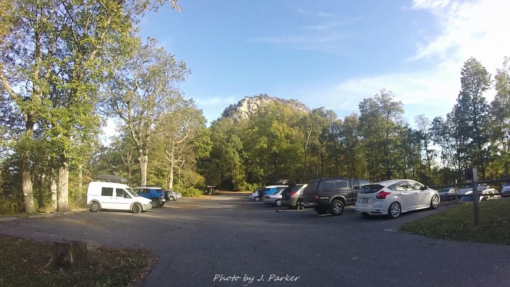
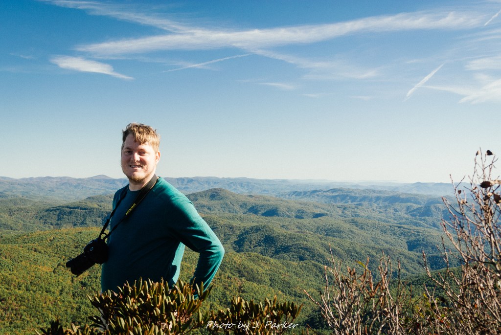
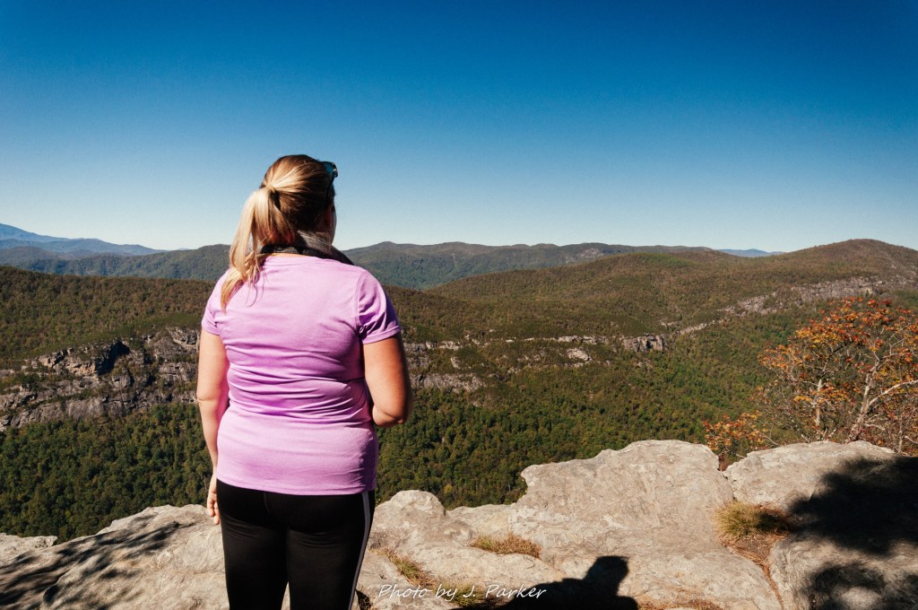
As we emerged from the Corolla in the parking area, embracing the feeling of ground under our feet almost as an astronaut returning to gravity would, one could sense the presence of Table Rock’s peak looming over the area, though the exact shape and nature of its ridge was still a mystery. That made the hike ahead all the more enticing. Reaching the summit of Table Rock requires a pretty steady and sometimes steep upward trek. The exact elevation gain eludes me, so I’ll just say that it is not negligible, but it is also not prohibitively strenuous for inexperienced mountain hikers like Jess and I. With the trip from the parking area to the peak being roughly a mile, neither its length nor its elevation gain came close to the hike we had done at Looking Glass Rock three days before, though its a good idea to follow the guides and hit this finger of the hike first, for the Chimneys, while offering their own unique challenge in the form of extremely rugged terrain, were almost flat by comparison.
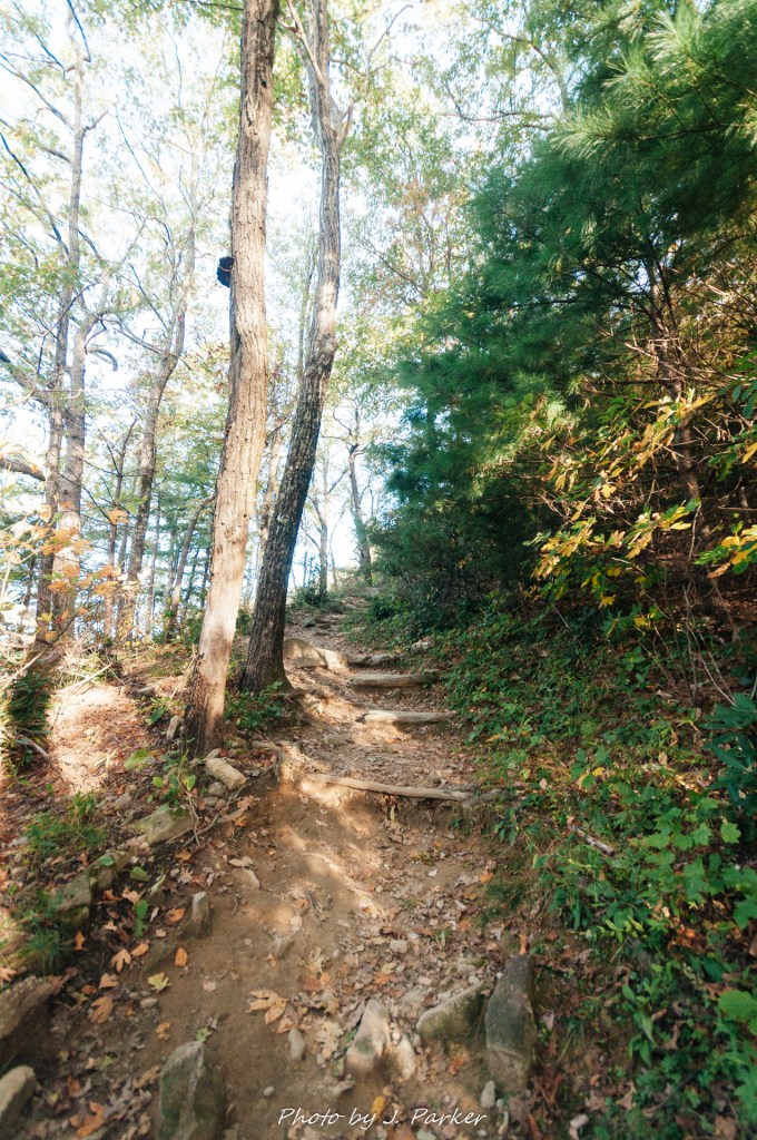
Upwards we started on the path which navigated rocky stairways immediately upon exiting the parking area. I ran the GoPro video as I narrated, eager to capture our journey upon one of my most anticipated hikes of our week+ long excursion through southern Appalachia. Never one extremely fit for mountain hiking, I was still surprised at how quickly my lungs grew heavy and my breathing grew labored as we worked uphill. We were coming off a “rest day” in Asheville where, despite not liking the city quite as much as we anticipated, we ended up walking as much as we had exploring from our downtown hotel as we would on most of our hiking days. Whether it was walking distance for days on end which had sapped our energy or the higher elevations we were and would be at for the rest of the trip I do not know, but despite making a point to eat at least two healthy meals a day I never seemed to catch my breath for the rest of the trip.
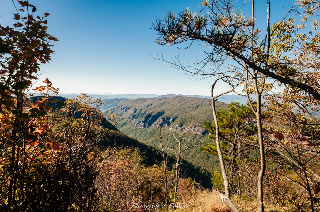
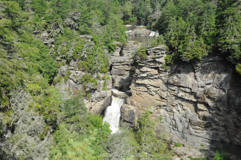
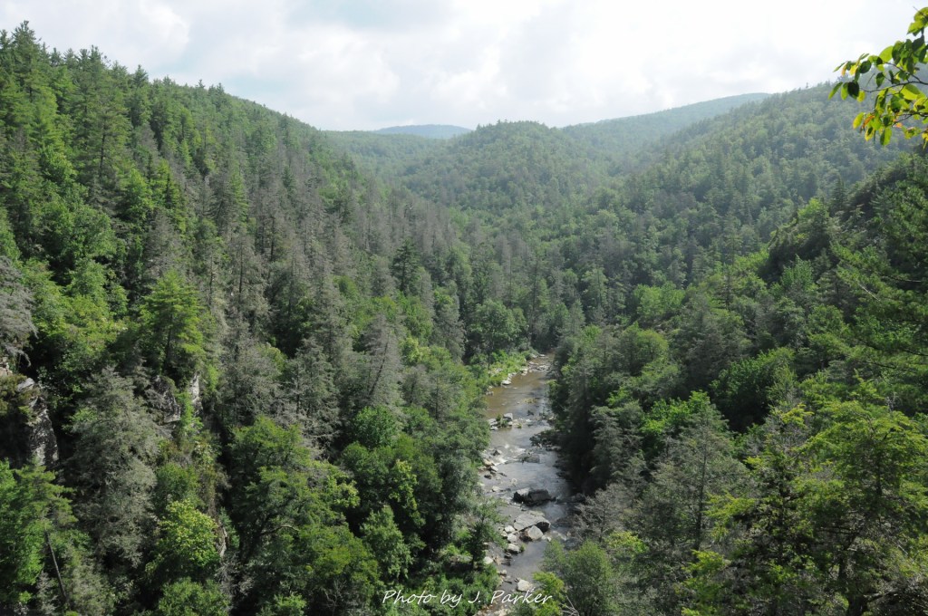
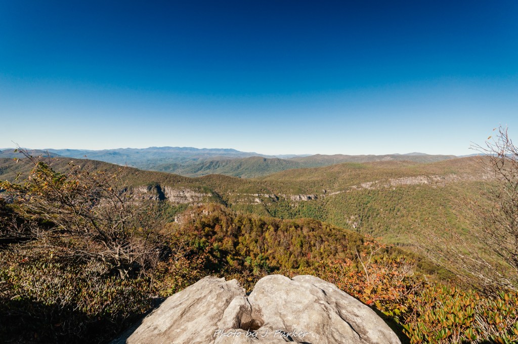
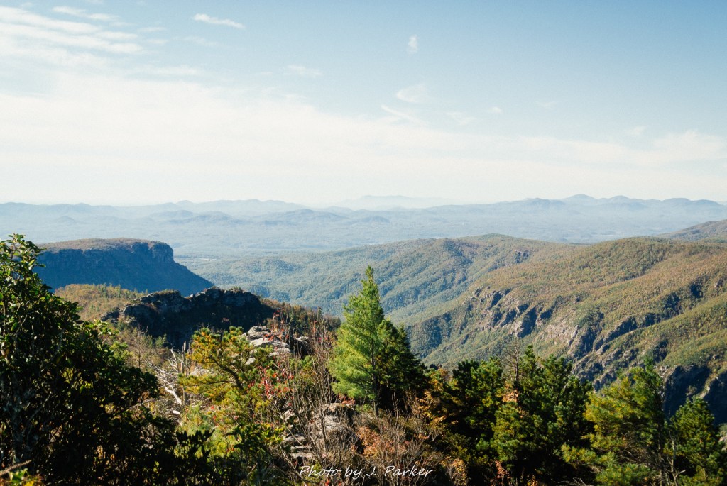
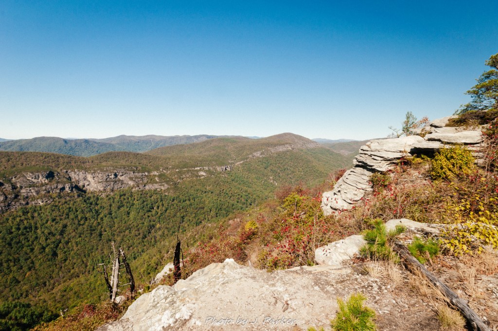
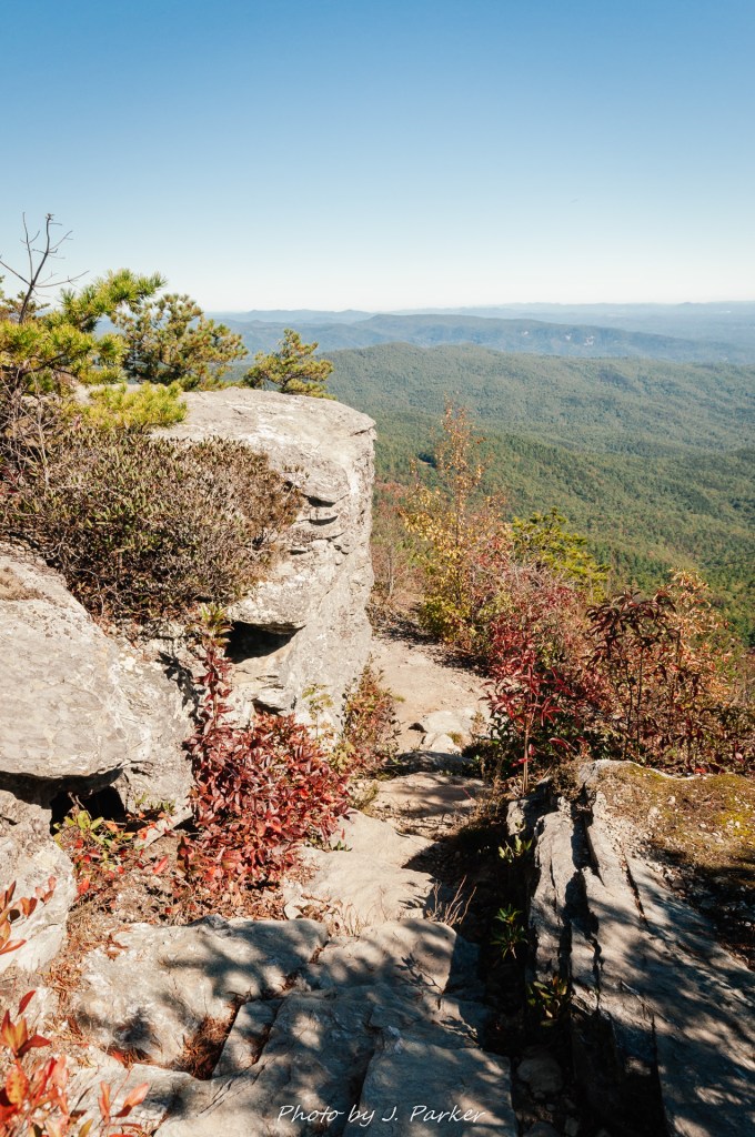
Though the Table Rock Trail challenges you right away, it also starts to reward you right away. Not long into the trail we came across our first window through the trees into the gaping chasm below, and it was a mesmerizing and otherworldly view. Parts of Linville Gorge are at least 2,000 feet deep, and when one is hiking along the rim like at Table Rock, every single view is impressive, even if dwarfed by others on the trail. We glanced through the opening at cliffs of staggering heights forming the opposite side of the canyon. I’ve been many places that look otherworldly in pictures, but Linville Gorge had a beauty which was hard to process even in person. The scale of the place is something that dwarfs nearly everything else in the eastern United States. Appalachia is a place with pockets and pockets of stunning layered beauty, but few places offer such large scale drama as Linville Gorge, and my mind had such a hard time fathoming the depth of beauty that it seemed to give up even trying to process it as real place. It seemed to assume my eyes were lying to me, but I knew it was real because I was there. Much better was to come, and though my lungs weren’t offering me the support I was hoping for, I couldn’t wait to press on further.
Onward we went again, with my lungs not being assisted by the cold air hanging around the north side of the ridge, where the sun’s warming rays were obscured. The trail clung towards the side of the ridge, but with a large line of shrubs and sometimes trees forming a barrier between you and the drop off below. Just two minutes after our first teaser view the shrubs opened up around a large set of rocks with a single solitary tree growing between the boulders. This view was the first one that really the depth of the gorge, for the last had been nearly entirely a side view but this one allowed you to peer down the gorge carved by the Linville River far below. This was truly amazing.
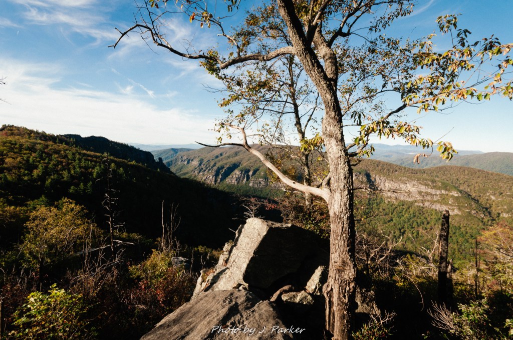
A large cliff wall to our right let us know that we were still a long way from the top, and it was almost unbearable to know that there had to be unfathomably cool views awaiting at the top, but we would have to finish the uphill trek to get there. The course grew rockier as we diverged from the Mountains to Sea Trail, which worked a path towards Little Table Rock further north, and entered the dedicated side trail to the Table Rock Summit. Sometimes the wide rocks contained many cracks and crevasses which could serve somewhat as natural steps as we made our ascent, but at other times the rock was flat and sloping. Sometimes the sloping rocks were slippery due to moisture which found the trail an easy channel to work its way downhill, while on others a layer of sand gave easy opportunity for slippage. While gravity tended to keep our feet stable on the way up, I felt a little uneasy about having to repeat our steps on the way down, especially as more and more portions of the trail offered no buffer between you and the gorge below as you ventured closer to the summit. I worried a lot about this, for if I fell off a cliff I might not be able to retrieve the contents of my memory card, and this was shaping up to be a hike that I really wanted to share pictures of.
I envisioned us riding downhill on our butts, a tried and true method that people from Florida use to safely navigate downhill sections, eliminating the risk of falling. I had no great comfort about these trail sections with nothing but a steep cliff to the side, but I was far more worried about how Jess and her vertigo would deal with this. She had locked up before on a trail with exposed edges, though fortunately it was on an optional side trek which she could avoid. There was no way to go up Table Rock without having to go back down, somehow (with falling off the cliff being one of the lesser appealing alternatives), so I savored the unimpeded, panoramic view we got as we neared the top, but with a mind filled with worry about how Jess, who was a few paces behind me, would react. But man, what a view it was. We had already gotten the view downgorge, which honestly didn’t change all that much from us being a view hundred feet higher, but here there was a clear view to the southwest down the sharp walls of the lower gorge, while to our north we saw the upper portion of the gorge in its entirety, with other ridges like Hawksbill Mountain lying further to the north as the outline of the river’s passage between the trees could be discerned far below. I was again to surprised to find the distinct flat crest of the Black Mountains and Mt. Mitchell clearly identifiable in the distance. We had seen the opposite side of that crest two days ago at Black Balsam, and I was beginning to realize that Mt. Mitchell’s tall ridge was visible from much of Western North Carolina. In only two days we would cap off our trip by visiting that highest peak east of the Mississippi, I savored the view for a bit as I waited for Jess to catch up, and despite my concern she seemed to not have any ill effects from the open view.
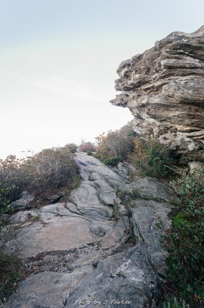
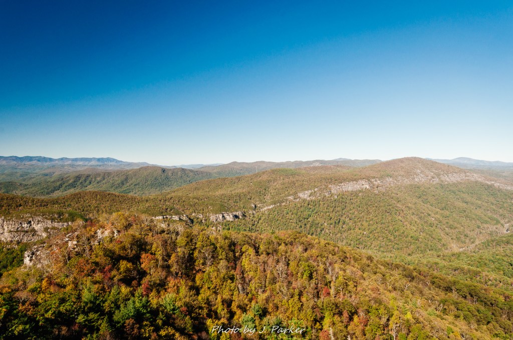
It was only a short distance from here to the top. The rocky pathway became even more chaotic as it navigated narrowly uphill between the brush. Much like we were surprised to find the roadway give way to the parking area on the drive up, we reached the summit of Table Rock without much warning, popping over a set of rocky natural steps and emerging onto a relatively flat section of rock. This section of flat rock was about twenty feet wide on all sides, and it was part of a greater expanse of relatively flat terrain which made up the “table” of Table Rock’s summit. An opening between the shrubs provided another staggering and completely unobstructed view to the gorge below. Flat in this case is a relative term, for although it contained occasional wide boulder faces like the one we were on, much of its terrain was exceedingly craggy and rugged, which combined with patches of shrubs prohibited free movement along the summit; yet many different pathways were open for exploration and access to different vistas. The multitude of options beckoned to us, and I was eager to explore them all, but for now I needed to take stock of what was right in front of us, which in itself was staggering. We were joined on the flat rock by an older gentleman with us dog. I wondered how difficult it must have been for the dog to navigate the rocky ascent to get there, but as dogs can be found in droves on North Carolina Trails (I’m beginning to thing it’s compulsory), and he clearly made it to the top, I suppose I shouldn’t have worried. We would encounter several more dogs before we completed the Table Rock arm of the hike.

With many side trails available, we took the easiest one first. A narrow but clearly traceable path to our right headed towards the northern end of the summit. We followed this one, eager for another portion of the view to be revealed (at some point from Table Rock’s summit you will be able to see in every direction, though I can’t recall a single point that has a 360 degree view itself). Here we reached a rock with a sharp cliff along its edge but which was flat enough and wide enough to allow us to explore without discomfort. There wasn’t actually too much we could see here that we hadn’t been able to see before, but for a while it felt like our own special, private spot, where we could enjoy the spectacular view without interruption. Amazingly, despite being some distance from the river and the falls, we could hear the sound of running water from far away. Linville Gorge is the only major gorge in North Carolina without a roadway in the bottom; thus, there isn’t much noise pollution, assuming there isn’t some asshat with a drone that sounds like a horde of bees nearby. I know not if the roar we heard was the river, the faraway falls, or some other, much closer waterway, but knowing the falls contain immense power and thunder when close by, I can imagine it may have been the sound of the falls we were hearing.
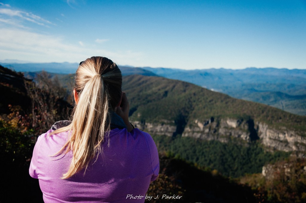
Here I gave Jess her assignment of photographing with the small, mirrorless camera, with a standard zoom while I photographed with my D90 and a super wide angle zoom. I liked the super wide angle to try foreground compositions but it tended to flatten out opposing ridgelines, sometimes making mountain pictures fall very flat. I didn’t want to miss anything about this awe-inspiring place. Jess likes to live in the moment and doesn’t want to be bogged down with the obligation of photographing, while I live for capturing moments so I can relive them over and over. I only ask her to photograph in special places and only for limited durations. This was a special place. To her credit, Jess enjoys capturing this scenic vistas as well (though she doesn’t share my affinity for waterfalls and the like), and she’s got quite a good feel for composition owing to her lifelong appreciation for art, with her natural instincts probably exceeding my own, and me only succeeding in photography just because of a desire to do so and learning over time how to make shots like which others also seem to like. I was glad to have her help me try and capture the magnificence of Linville Gorge, as in an obtuse way, sometimes the difficulty of capturing a satisfactory shot of a place increases with its real life beauty, where so many opportunities can present themselves that its hard to find select frames that possess that same beauty. Its simple when there are only one or two good views at a place and you only have to frame those views well. More than one time on this trip the best shot of a location would come from Jess.
We retraced our steps and then began to make a rocky course over the top of Table Rock to catch the southern end of this peak. Parts of this passage were definitely a rock scramble, but made from the safety of the middle of the “table”, without steep drop offs to make one worry a mistake might be fatal. Jess wasn’t sure she wanted to follow me through that rocky course, after navigating some twenty yards I assured her that it was eminently accessible and worthwhile. I took pleasure in standing on what I thought was the tallest rock of Table Rock, thereby “peak-bagging” this notable ridge, and savored the moment as I looked over the precipice to the chasm stretched out before me.
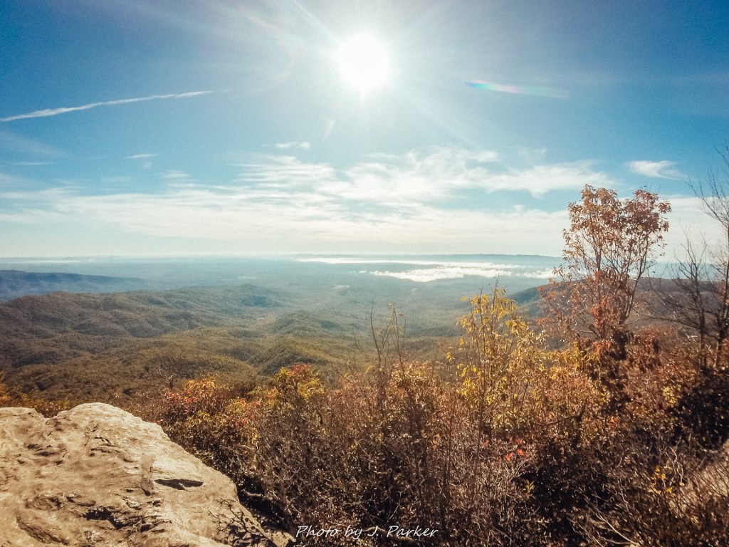
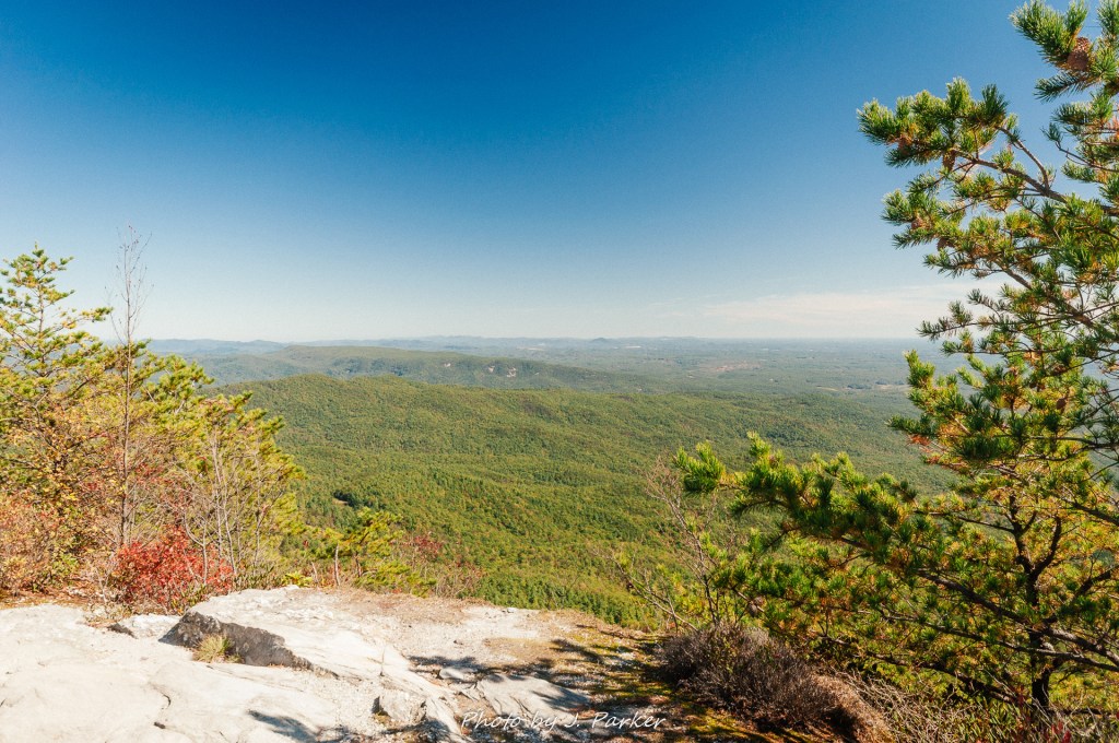
From there I completed the rest of the rock scramble to the southwest peak of Table Rock. When one looks to the north and east of Table Rock the view includes the massive drop of the gorge below, but it is also filled with peaks of similar or even greater heights. Not so on this side of Table Rock, where instead your view is filled with foothills that are vastly shorter, giving perspective on just how significant the rise of the Blue Ridge really is. From here can see far in the distance, and Lake James, which lies past Shortoff Mountain outside the gorge, is clearly visible. Thin layers of clouds filled the valley in pockets, adding some depth to the scene. The view was magnificent if only it hadn’t been looking directly into an intense morning sun, thus we didn’t get any real pictures of the view from this direction, but I did take a GoPro snap before leaving.
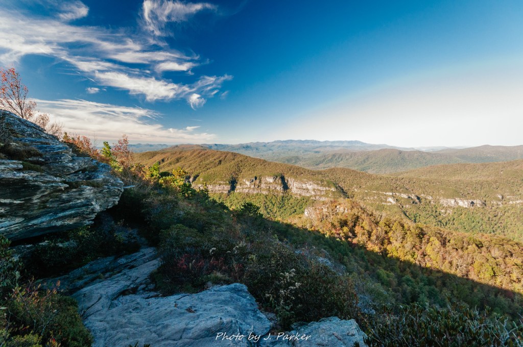
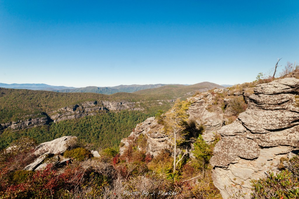
We worked our way out to another flat rock towards the east side of the summit. Jess captured because the most layered shot of the gorge we would get this day. I was taken aback when I discovered this shot while searching for pictures for this write-up, as I felt like it captured everything that makes the gorge seem otherwordly in one shot. We were far from done with great scenic vistas – in fact we were just beginning. In hindsight though, I really feel like this is the most spectacular we encountered on the entire hike, just for the way it let you view both up and down the gorge. In fact, I would go as far to say as it may be the best singular scenic view I’ve ever come across, though I only realize that now. I didn’t realize this in person on that day just because it came wedged a half dozen views before and another dozen or so after it, many pretty similar and awesome. If one hiked three miles just for this one view, it would stand-out more in the mind.
While savoring the view I had to contemplate how it compared with the Smokies, which are an equally amazing place for different reasons. For the most part, the vistas are much harder to come by in the national park, but they are there and I’ve experienced quite a few that were truly impressive. Yet their beauty lies somewhere different, exuding from mostly green peaks which dot the horizon, sometimes blanketed by ethereal fog which can cause the view to change by second. Linville Gorge, on the other hand, thrives on jagged rocks and distinct peaks. It’s amazing to think of the variety one can experience in a relatively short distance by visiting the rugged area of Linville Gorge and Grandfather Mountain, then the open balds of the Great Balsams, and then the deep drama of the wooded, foggy Smokies, with all these places viewable from or not far off the Blue Ridge Parkway in North Carolina.
By now we had taken in a view from every direction at Table Rock. We certainly hadn’t taken in every social trail, goat path, and rock scramble the peak had to offer. Our visit to the summit felt rather complete without having to explore all of these paths, which seemed to offer a lot of risk with their abundantly rocky, sometimes steep elevation changes, without offering much reward. The best decision was just to retrace our steps, which was also recommended by our trail guides. Our explorations at Table Rock weren’t over though.
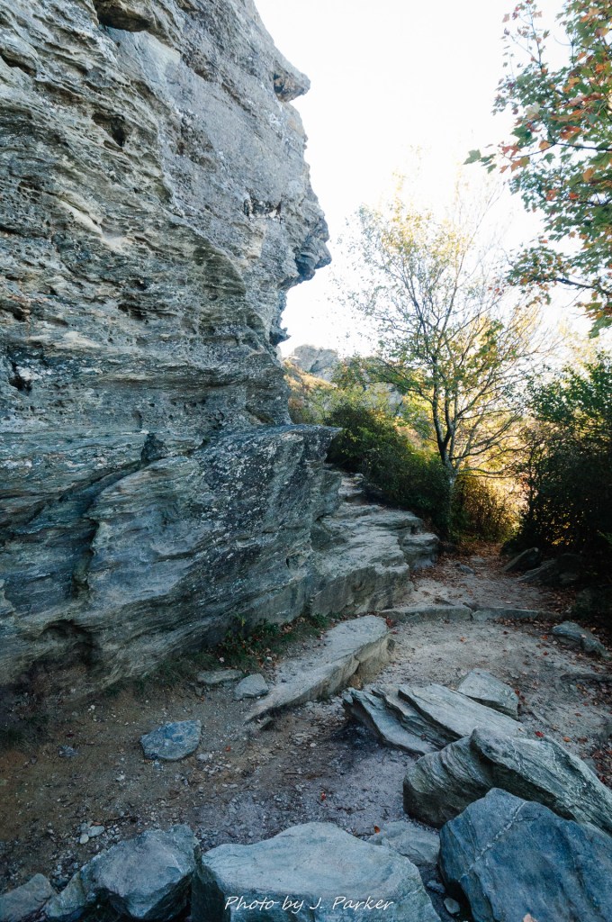
We also had good directions to the Devil’s Cellar, an interesting rock formation that forms a deep canyon between it and the greater Table Rock. On the way down, we made sure to utilize butt sliding as much as possible, as a fall on this descent could have dire consequences. We both made sure to concentrate through the more difficult downhill areas, but Jess let her guard down on one of the more innocuous downhill rocky sections and lost her footing, fortunately falling on her butt and suffering no more than a pasty stain on her pants. The side trail to the Devil’s Cellar was easily spotted; we had seen it on our way up. The path was somewhat narrow with the brush encroaching but it was an easy passage of a few hundred yards to reach the deep split between the rocks that was the focal point of this side trek.
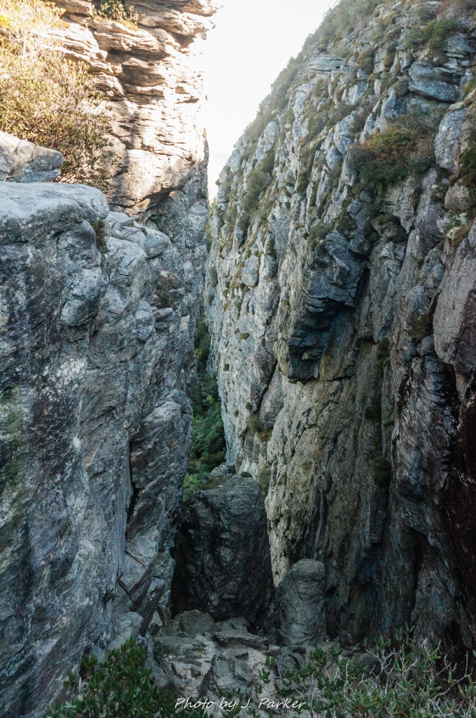
The Devil’s Cellar was more than worth the short side trek. While peering into the chasm hundreds of yards deep, I thought aloud about how I hadn’t really seen anything like this in Appalachia before. The rock walls towered hundred of yards high while before me the rocks made a steep descent. I wondered it this was something if people tried to scale; it didn’t seem impossible, but wasn’t something I’d be interested in. Looking into the cellar wasn’t the only benefit of this side trek, for the rock to the left of the cellar also made for another phenomenal view. We were certainly hundreds of feet below where we had been on the summit, but in the grand scheme of the gorge that didn’t diminish the view that much. We also got a view of an adjoining ridge line on this section of the gorge, one which sat far below the towering peak of Table Rock. I wondered if this could be Little Table Rock, I am still not sure. The real benefit of this rock is that nobody was making their way out to this side trek, so even on a rather busy day on Table Rock we had an immensely quiet area to savor the views.
This was our last stop on the Table Rock portion, but even upon reaching the parking area our hike was not even halfway over. On the opposite side of the parking area was the trail to the Chimneys, and after stopping to utilize the facilities of the parking area we embarked upon the pathway, passing a sign shortly into the hike that denoted our entrance into the Linville Gorge Wilderness. There were many tents dotting the infrequent open spaces here. The climb up was much more gradual here, and flat, open space was available which simply didn’t exist on the steeply ascending terrain of the Table Rock trail.
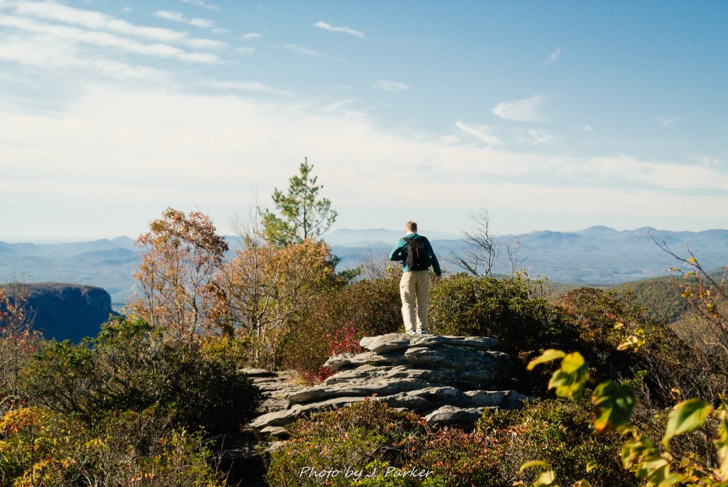
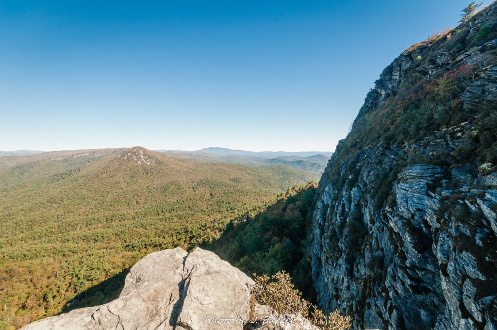
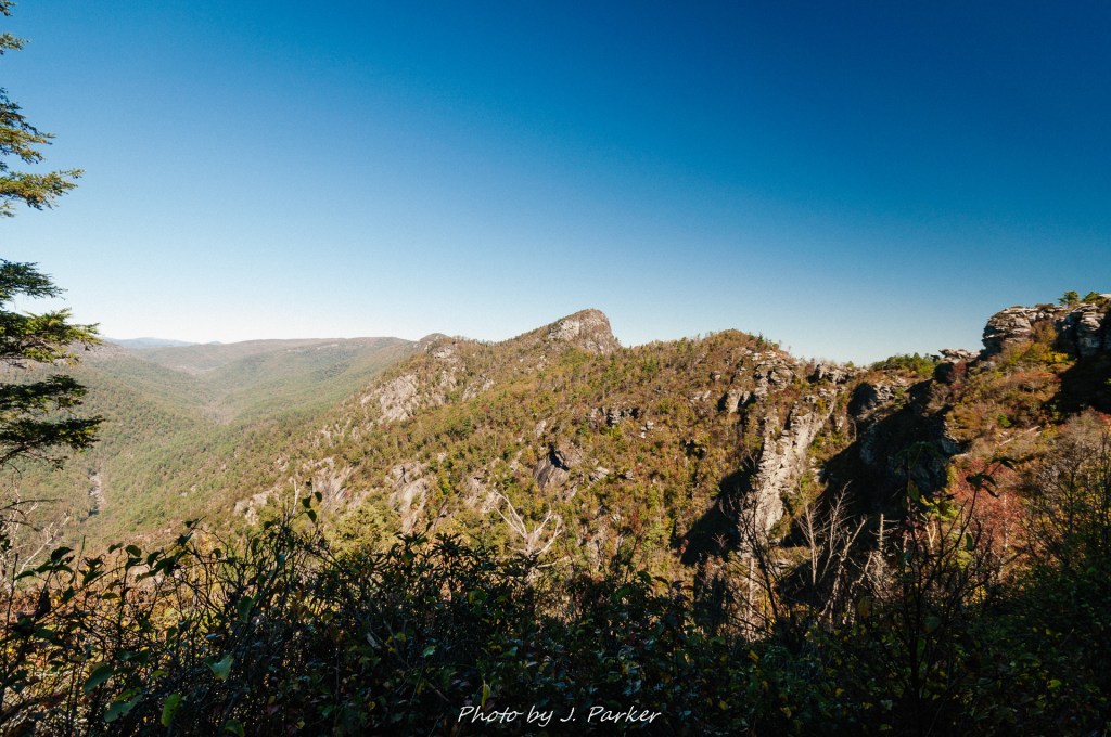
I was very excited to take the first side trail which afforded the opportunity of a view from the Chimneys. I had no idea what to expect as I made my way up a series of rocks to an open rock slab looking towards the Northeast. This opened up to a view of Table Rock in its entirety, and what I saw absolutely floored me. We had seen the top of the rock from the parking area, but that did little to truly outline its unique beauty. The rock was round, audacious, sexy, unique. I had never seen anything like it. It was hard to imagine I could have enjoyed the Table Rock section of trail more than I did, but it would have been even more enchanting had I known the true majesty of the peak we were summiting. That’s the only downside to doing the Table Rock portion of the trail first; you’ll appreciate ascending the peak even more if you know what it looks like. There’s nothing quite like seeing a distinctive peak and knowing you’re going to conquer it, and you won’t get that feeling if you hadn’t set eyes upon Table Rock in person. Given the far more challenging ascent up Table Rock, I wouldn’t change how we did this hike, but that is one downside. As the rock we were on had a few trees that somewhat blocked the view, I used ever inch of ground I could to make sure I could get a sweet unobstructed frame of this beauty, one of my favorite peaks.
Not long after our surprise Table Rock view we began to get views to the right, as there were several flat rocky vistas in quick succession. We chose one of those for our impromptu snack spot, and I savored my beef jerky and ramen noodles with still one of the best views I’d ever seen streched before me. In many places the view to this side was not dissimilar to what we had obtained at Table Rock, but it did offer the opportunity to gaze open the odd rocky formations on either side of us along the Chimneys. The most enjoyable views from the Chimneys were often of The Chimneys themselves, a rare feat.
As we emerged deeper into the Chimneys it became evident that this was a completely different animal from Table Rock. For most of the Table Rock portion you were steeply ascending, with the occasional flat vista and the outstanding spots of the top offering pause. There is but a relatively short, gradual ascent to reach the Chimneys from the parking area, and the ridgeline offers but minor elevation changes, yet the tremendously craggy surface makes passage of this area more difficult than its companion on the other side of the parking area. While perhaps falling short of a true rock scramble as a whole, nevertheless there are still times when one literally has to climb up and down the rocks, with sometimes very little space between the boulders one is trying to navigate. The Chimneys can be as little as ten yards wide and rarely more than thirty or so, which means for much of the time you’re navigating its challenging surface you have a view of the gorge to the right, the piedmont to the left, and ahead of you the jagged chaos of the peaks. When viewed from afar, it’s easy to wonder how its possible that people could safely traverse its frantic ridge.
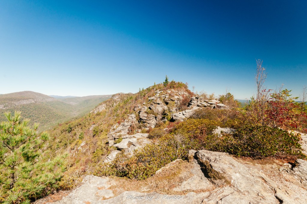
Table Rock and the Chimneys are so different that it’s hard to imagine doing one without the other. In the absence of physical limitations, first time visitors to the area would do themselves an injustice to not hike both, especially since the two together are still a very moderate hike. Even having done them both, I wouldn’t hike one without the other unless I was doing a much longer hike in one direction. Even then it would be hard to ignore the temptation to add a lot more to the hike with just a little more distance and effort.
We plunged deeper into the Chimneys, which seemed to get more and more chaotic the further we ventured. It’s hard to recount blow by blow each step of the way, as there are countless moments of butt slides, rock climbing, and squeezing through crevasses, all while being blessed with those great views in at least two and usually three directions. While doing all this, I wasn’t too sure how we were going back to the parking area. The directions I had described a loop working its way back to the right, but I had never at any point noticed any sort of real pathway coming in from the right since we had left the parking area. I couldn’t even really fathom where it might come in; for much of the hike nearly sheer drop offs are present to the right (though not frequently right against the trail), and it would be physically impossible to have a trail there.
I was hoping there was a loop, for there was a particular section I was loathe to repeat. The trail had nothing on the left but a steep dropoff, and one had to climb up on a rock with only a foot or so width of trail to separate you from death below. It was one thing to climb up that, but having to go down with only that small landing at the end was a rather terrifying prospect for people from Florida. Another section of trail was after the bulk of the rocky sections had been passed, where we had to navigate a narrow section of trail. that was only 2-3 feet wide, with rocky uneven terrain and for the most part a sheer dropoff to the right, though sometimes a narrow band of shrubs provided a small buffer. I directed Jess to lean to the left and kept her weight down as she navigated that section. For myself, I uttered some woods I wouldn’t want my nieces and nephews to hear. I let out an immense sigh of relief once I had successfully navigated this 30-50 yard stretch which seemed much longer than that measurement would imply. For better or worse, there was scarcely a dull moment almost from the beginning of the Chimneys portion of the hike, something I couldn’t say about the Table Rock portion, or many hikes for that matter.
We emerged unscathed from that rather harrowing segment and found more interesting things to view, now with us somewhat below the ridgeline and having a rock wall some 20-30 yards high to our left. We encountered a small cavern to our left, one in which you could climb into and find a vast open space between the rocks. Charred remains left evidence that people had been using this as a campsite recently.
We were now nearing the end of the Chimneys proper, and I began reading my directions and looking intently for the trail junctions described in my guide. The rock gave way to forest, though this forest was rather barren and open as it had been charred in a forest fire not many years prior. To my chagrin, the trail junctions I was attempting to find to direct my path just weren’t where I they would be. What side trails I did see, which I couldn’t positively identify as the ones I was looking were far more adventurous than I was willing to undertake without knowing definitely where they would go. I did try to follow one down, figuring that any side trial would lead to something truly interesting here in the gorge (as almost everything was truly interesting here), and I figured that it might provide a landmark to give me some orientation, but alas the trail got too steep for me to entertain it any further. I wasn’t crushed by this, for my intention for this day had always been to do Table Rock and The Chimneys, and I knew ahead of time some of the side trails might be beyond my skill level. With the wondrous views from both locations and the awesomely fun cragginess of the Chimneys, my hike felt more than complete, even if there were additional stops that could have added more. As a nature enthusiast, you have to know where your skill level is, and I’ve learned that the hard way on a few occasions.
Getting the reverse view of the Chimneys as we hiked back wouldn’t a bad thing. We would, on the other hand, have to repeat the dicier sections of the Chimneys along with the better ones. This turned out to be easier than expected, since we navigated most of the more challenging sections uphill this time, which is always easier in the sense of keeping stable footing. As for that one narrow ledge you dropped into, I did everything I could to just keep my butt plastered on that rock as I used went down it step by step. It wasn’t near as bad as I thought, and the worst thing that happened was that Jess followed me so quickly I wasn’t able to get a shot of her with the GoPro as she navigated that descent. It would have made good footage.
Knowing it would be our last view of this Appalachian wonder for some time, and certainly for this trip, we grabbed a perch again along one of the rock vistas to savor it for a few more minutes. The rest of the walk back to the parking lot was rather simple, the drive that had been so harrowing on the way up required a lot of careful break work but was otherwise ok. It had been a great half a day so far. We had enjoyed a fantastic hike under perfect, untarnished blue sky, and successfully navigated both treacherous trail and road without incident. It had been the most adventurous hike we had ever done, and by that I don’t mean numerically challenging hike, which it was not, but there was nothing we had yet done which contained the same challenging rock sections of consistent exposure to open cliff face. I had envisioned Looking Glass Rock as a level-up hike for this trip; instead, Linville Gorge was the real leveling up.
There were hikes from this amazing 2017 trip that I enjoyed more at the time, but years later this Linville Gorge hike looms the largest in my memory. It’s a great hike, one of southern Appalachia’s best, and I would say I wouldn’t hesitate to return if only for the fact that Linville Gorge offers some other signature hikes like Hawksbill and Shortoff that I simply must do at some point. I’ve not yet been able to return to the gorge; I made plans to visit Labor Day Weekend of 2019 but was forced to abandon those due to the threat of Hurricane Dorian. I’ve had a multitude of trip options for 2020, some of which have included the gorge, none of which can be planned for owing to a combination of the coronavirus and a re-injuring of my hip which will render me immobile for uncertain timeframe, much like the year I visited the gorge. Even if I’m unable to make it back soon, I implore anyone who wants to see Appalachia’s best that they must get to this area at some point. And if they do, I can’t imagine a better starting point to the gorge than this signature hike.