I couldn’t feel my legs. That might have been a little more disconcerting than it was, for at least it had a rational explanation. I had been standing in near-freezing water for nearly a minute (I have it on good authority that I could tell it wasn’t freezing because it wouldn’t have been water anymore). I was standing, barefoot, in the Big East Fork, a river that drains an area flowing from the Black Balsam/Graveyard Fields area of the Pisgah National Forest. It wasn’t for no reason that I was doing this. I didn’t recreationally try to catch hypothermia. It was the only way I had found to get a good picture of the river containing solid traces of fall color on this brisk fall day.
I could hardly believe I was there. Not necessarily the water part. I had long since shed my reservation for wading in even near-freezing water if it’s what you’ve got to do to get the shot. After all, you came all this way, why let a temporary inconvenience stop you? No, it was just being in North Carolina in general. I was going to spend a whirlwind five days cruising areas around Asheville, chasing trails and photographic opportunities. It wasn’t under the best of circumstances though. My hip, after going bad at the end of February, had simply never come close to being right. I was living every day in pretty significant pain, and thus I was having surgery exactly two weeks after my visit to the Big East Fork. As I had a feeling, rightfully I would find out, that my hip wasn’t going to endure surgery without complication, I was going to take my whirlwind solo trip to enjoy a last foray before I would be unable to hike for months and months. Not that hiking on a bad hip was going to be easy; there was a reason why I was having surgery, and as I visited the Big East Fork that day I legitimately didn’t know if I’d maintain an ability to do much of anything. It would turn out that I would make it through my trip ok, albeit with a hip feeling like it had a dirty dish rag wedged inside it and at a slower pace than I’d ever managed before.
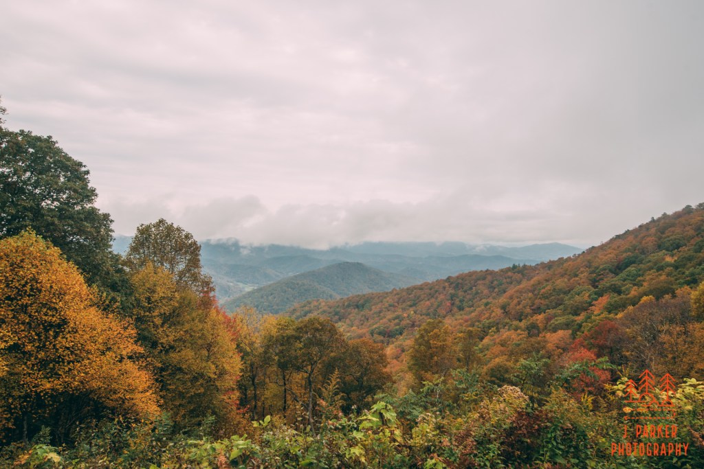
I had gotten into Asheville just before noon, and after grabbing supplies at a gas station I would quickly embark upon the Blue Ridge Parkway. I had to be in a hurry, for at present the weather was delightfully cloudy and gloomy, but the weather was predicted to shift to abundant sunshine and stay that way for the duration of my trip. Some would consider this a godsend, and while it’s never unpleasant to be high up on a mountain under a flawless blue sky, I would have preferred it to be mixed with moments of cloud cover that would allow me to photograph creeks and falls. As it was, the only guaranteed cloud cover I had was going to last for a select few hours after my arrival in North Carolina, and I’d have to make the best of them.
With glee I entered the Parkway’s winding course, exulting as I climbed elevation and obtained both moments of views and patches of fall color. This was the reverse course from what my wife and I had taken just a few months prior, where we ended a nice hastily planned mountain trip with a cruise along the Parkway from Richland Balsam to Asheville. Color seemed to be pretty good not too far out of Asheville. Nice as it was to witness, this worried me a little bit, for these elevations were a lot lower than the ones I was likely to be hiking in most of the trip, which were going to be 4500-6000 feet. As a Floridian making only his fourth ever trip to the mountains in fall, I don’t claim to understand it all very well. In fact, the stress of trying to plan and predict where you can hike in fall color just makes me long for summer, where everyone you can hike will contain amazing patches of greenery. If you make a wrong decision, you can end up an area that not only lacks good fall color, it may be in “fell”, where the trees have become barren, resulting in sometimes lackluster hikes, especially considering that somewhere there’s a hike laced with abundant color.
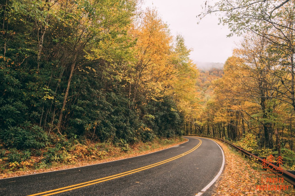
I wanted to be quick to my trailhead, but I couldn’t resist stopping a few times to take in the rather ethereal day happening along the parkway. The first place I stopped had a good view, but my reason for stopping had more to do with the fact that I had spent the last moments of my last moment trip taking in the sun as it set here. These moments are also poignant for a Floridian, when you have to soak in one last mountain experience and return to a land of mind-numbing flatness and monotony. I was sure to snap a cell phone pic for my wife and send it to her, knowing she’d recognize the spot. The road was painted with shades of brown and orange as I moved forward to another overlook, this one of the opposite side of the parkway.
I made another stop here, for I could not resist gathering in the surroundings on the opposite side of the parkway. I promised myself, though, that I wasn’t going to stop at any more overlooks on along the Parkway before reaching my trail. Good light was only going to last so long; there’d be plenty of time for overlooks later.
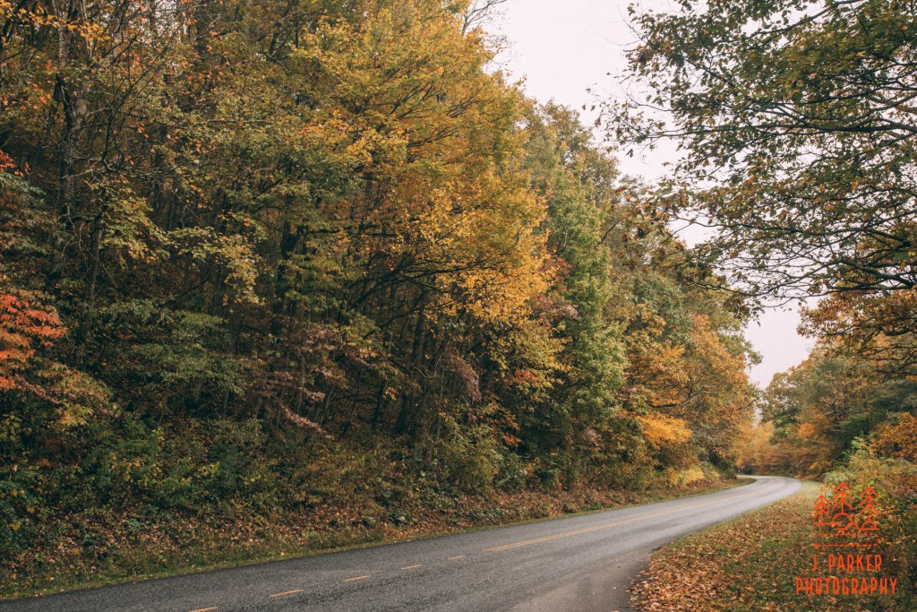
I was heading towards the Parkway’s intersection with U.S 276 coming north from Brevard. South of the Parkway I was decently familiar with 276, but the spaces to the north seemed like the untamed wilds, possibly filled with dragons. Until this trip, that area had just been a mysterious region of the map. Today, I would start filling that in. I hadn’t been given a compelling reason to go there until, while searching for tranquil creek walks, a nature friend of mine just happened to share some images from the Big East Fork Trail. With a low-key trail mostly following a rapid-filled river, it was exactly what I was looking for. I began to feel the fog of war lifted as I turned off the Parkway to head north on 276, and an illusory place on the map began to become a real place.
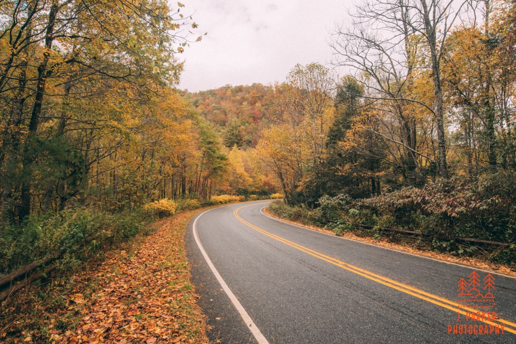
The Blue Ridge Parkway was carefully constructed to avoid steep grades and sharp turns. Not so all the connecting highways, and 276 was no exception as it sharply wound its way down from the ridgeline where it had met the Parkway. The road was closely enshrouded in trees as it bore it’s way on a curvy course downhill. I carefully selected a spot to pull off to get a few snaps of the road, for its not everyday in Florida that we encounter a road running downhill through a fall forest.
The scene appeared somewhat magical as I pulled into the Big East Fork Trailhead. The trailhead was close to where the road crossed the river, and naturally it was a low point between the surrounding ridgelines. The cloudy sky brought out the thick patches of orange, while collections of water vapor, somehow not quite cloud or fog, quickly traversed the valley before colliding with the ridgelines that captured and collected the vapor. I walked down the road a bit to get a better view of the scene before I assembled my supplies for my short foray into the forest and along the river.
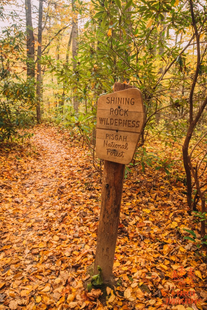
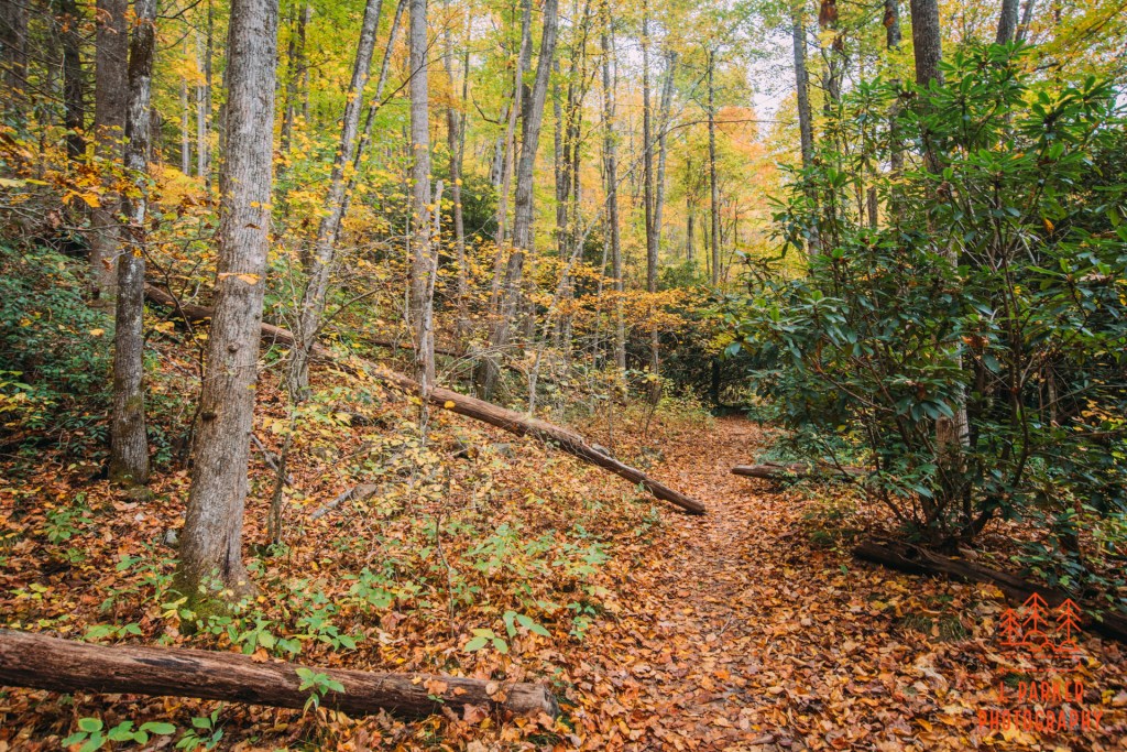
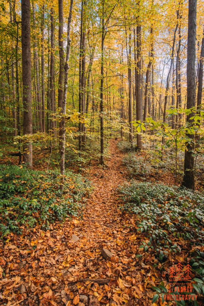
Starting out a big hiking trip out of state is always a rather surreal moment, and as you set out for the first time, not quite in the swing of things just yet, always afraid that you’ll forget something among your camera equipment, food supplies, rain gear, etc. In this case I did forget something I would have preferred to have, which was mail trail directions and map. The Big East Fork Trail wasn’t a place where I was worried about getting lost. After all, I was just taking an out and back that mostly followed a river. Still, there were moments were the trail diverted from the river, at one point for good, and not knowing exactly where I was on the trail’s path was going to complicate things at a certain point. I set out on the path, quickly passing a sign that denoted I was heading into the Shining Rock Wilderness. This area is so filled with different wilderness areas, I could scarcely keep track of them. I’m pretty sure my hotel room had a bathroom located in a wilderness area while the rest of my hotel room was also in a completely different wilderness area. Such is this part of North Carolina.
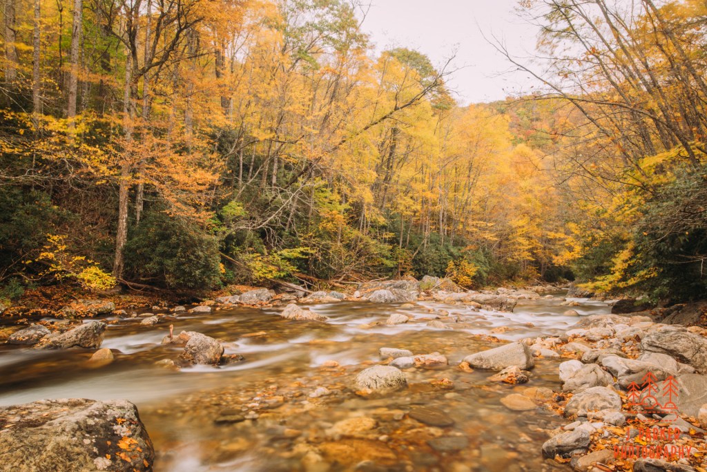
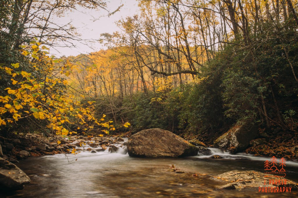
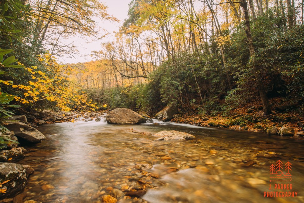
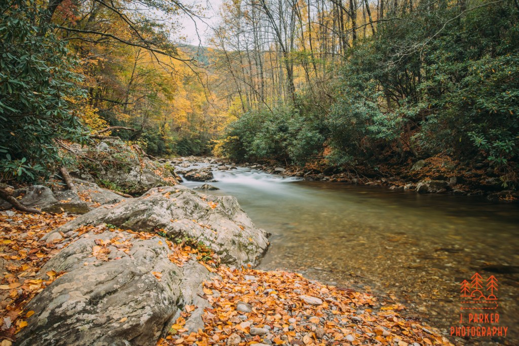
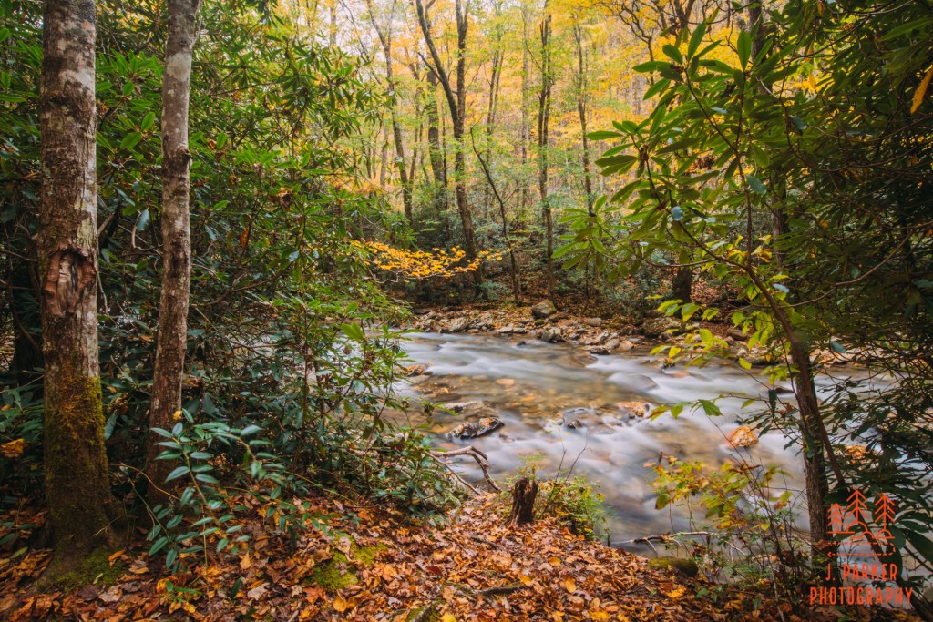
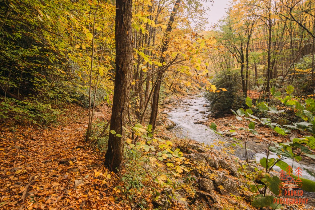
I was hiking this trail for one purpose only, so I took the first offshoot I could find which led me to the river. In a short time I was there. Well, not quite at the river, but I could see it. Between me and the river was a small field of smooth rocks of all sizes which had obviously been shaped over the century by the flow of the river as it undulated. Making navigating a rock field one of the first things you do while hiking with a bad hip that left you with shaky footing wasn’t idea, but there wasn’t really any clear terrain between me and the river, so I had no choice but to carefully find my footing through the rocks to get a better view if I wanted to see the river. Surrounded by its field of rocks, with more large orange rocks within its flow, and even more orange found on the canopy along its banks, the river made a striking scene here. The riverbed was quite wide here, and one could look downriver and see the opposite ridge towering overhead, something not always common in Appalachia where surrounding ridgelines are often obscured by the trees nearby. It’s rockstrewn banks were not easy to navigate nor find a good place to setup a tripod or frame a shot, and I could tell that while the hike was going to have ideal scenic splendor, capturing that in a photograph was going to be a challenge.
I did my best to capture this first river spot, and I came away with a few decent shots that don’t really bear witness to how tough it was to move around. I moved up and down river for a short distance as best I could, but there wasn’t quite that “it” shot that was really bang up. Getting that first “portfolio” shot is something I always want to get accomplished early in a trip. Until you do, there’s always quite a bit of anxiety and a sense of failure. I was enjoying my time here, but the good light was going to be short, so I didn’t linger too long.
While the first portion of this trail was near the river, the river wasn’t in sight like it would be later, so I had to take every offshoot I could to get close to the river. The next offshot I came to brought me to a spot where one could barely find footing between the brush and the river. I was tantalizingly close to a nice set of rapids, but getting a nice frame of them was going to be just out of reach. The rapids weren’t close enough for me to consider getting in the water here, and that was less to do with the temperature of the water and more to do with how difficult navigating a lot of slippery, uneven rocks in a moving current would be, especially while trying to keep my camera dry. Still, I was really beginning to like the way the river was looking, and getting very excited as to what lay ahead.
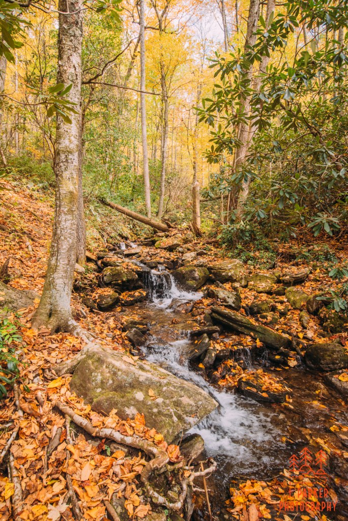
Moving on, there was another really cool spot accessible. Coming out there was enough space to move along the left side of the river. On the opposite side of the river a small creek tumbled in and made a small waterfall. These small waterfalls don’t really make for much in a picture, but it definitely adds a sense of ambience and mystique to an in-person experience. I enjoyed seeing the waterfall as I tried to make my way past to work upstream, but I again met an obstruction and was stymied yet again.
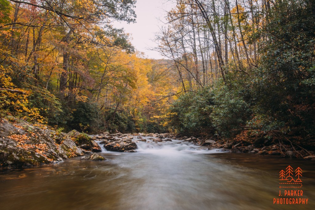
At the next opportunity to reach the river, I came across the most photogenic spot yet. This spot was in a nice where the river went from a tight channel to a wider one as it headed downstream (I was hiking upstream), and the foliage framed it rather nicely as its path narrowed when you looked upstream. I paused to take in the scene here, pleasant enough, while keeping one eye upstream to see if this would finally be the place where I could get a nice front shot of a set of rapids from downstream. Intrigued as I was, I was entranced by the view downstream from this spot. Downstream shots are rarely as pleasing to the eye without the intrigue of the water moving towards you, but I couldn’t ignore how interesting it was seeing the river with a towering ridgeline in the background as mist flowed over it. The picture didn’t quite come out as well as I was hoping, but the scene was so striking in persons I’m glad I captured it.
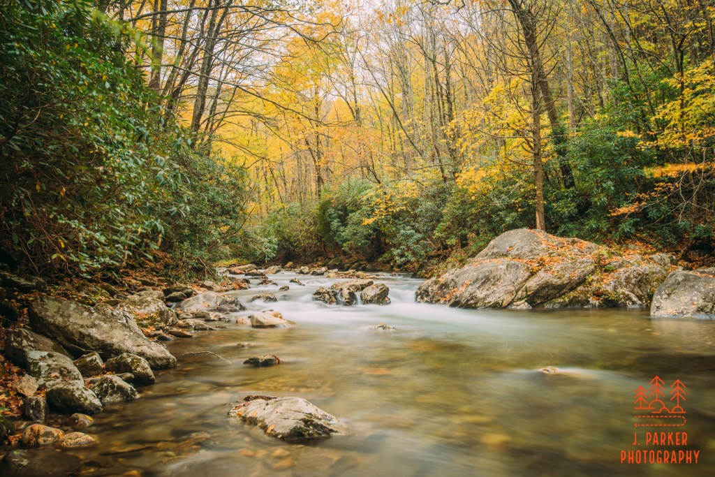
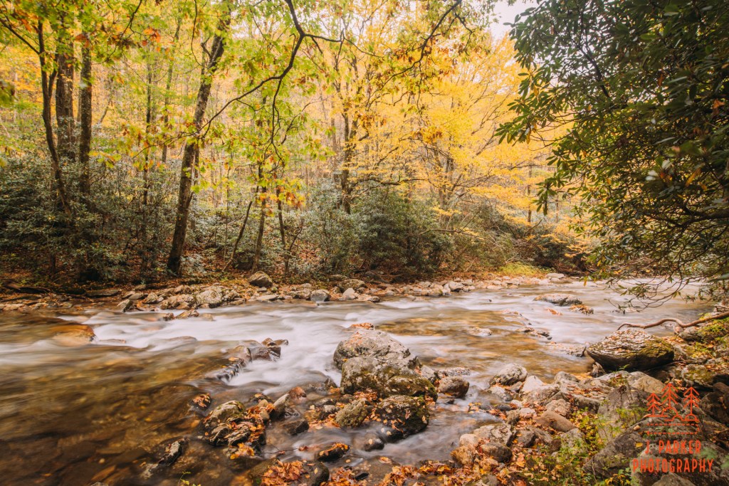
I headed upstream until a set of slick, steep rocks impeded my passage. The nice set of rapids lay just ahead, and a subtle river bend behind it meant the canopy of highlighted the rapids from behind. The canopy was especially nice, for while there were pockets of orange here and there, it was also a bit inconsistent, with a fair number of trees already being rather barren and past peak. Chances are, many of the places I wanted to visit this trip, which were higher elevations than I was currently at, were probably going to lean towards the barren side. I wasn’t thinking about that at this point, instead I was trying to get a nice shot of these rapids.
Thus far I hadn’t really gotten the frontal view of a set of rapids with color in the background I was looking for. Here, though, the river was relatively shallow, and its clear water I could see the bottom was relatively flat and devoid of the slick rocks which could make my journey a rather unpleasant one. Given that I hadn’t had much luck thus far, I had little hesitation about what I would do next; hop in the creek, tripod and all, for a shot. I knew the river would be very cold, but temporary inconvenience is just the cost of doing business. I was 700 miles from home, and letting a little brief coldness and possible hypothermia stop me from getting the shot after I’d come so far would be silly. In the blink of an eye I was removing my shoes and socks, the only concession I’d make to the cold water. That had as much to do with the limited number of shoes I had with me on the trip; once you submerge your shoes, they don’t really dry out in the course of a 5 day trip. Not when you’re arriving late and leaving early from a cheap motel room, anyway.
My toes entered the water and almost instantly went numb. If Jack from the Titanic had been with me, he’d certainly not last more than a couple minutes. I wasn’t going to let him on my raft either. I took each step carefully, for not only is walking in water with your camera always a treacherous proposition, with my hip preventing me from normal walking for months, I was far stable on my feet. But I took careful steps, and went out to as far as I was comfortable which, to my chagrin, still wasn’t quite close enough to really zoom in on the rapids. Curses, I still had my wide angle on, and 35mm on a full frame camera doesn’t get you very far. But my hands were wet and freezing, and I wasn’t going to be repeating what I had just done a second time, so I zoomed that thing as far as I could. As far away from the rapids as I still was, I would have loved what I could do with my nd1000 and a 30 second exposure. But the water was so cold, and my legs still so unstable, we were gonna have to get the best out of my nd8 right now. With each long exposure I took I counted down the seconds that seemed to move in slow motion. Time couldn’t have moved slower if I was being forced to listen to “A Horse With No Name”. Finally I was satisfied I had done the best I could, and carefully moved back towards the bank where I hoped I would eventually be able to feel the lower half of my body again.
The river had started to get really photogenic, and the orange trees behind the last set of rapids really had me anxious to move forward. In my mind there was a clock ticking down to the clouds dissipating and my beautiful cloudy day becoming abundantly sunny. I hastily grabbed my gear and, feet still being wet, I shoved my socks into the closest camera bag pocket I could find and moved forward as if I were a cat in a court hearing on zoom.
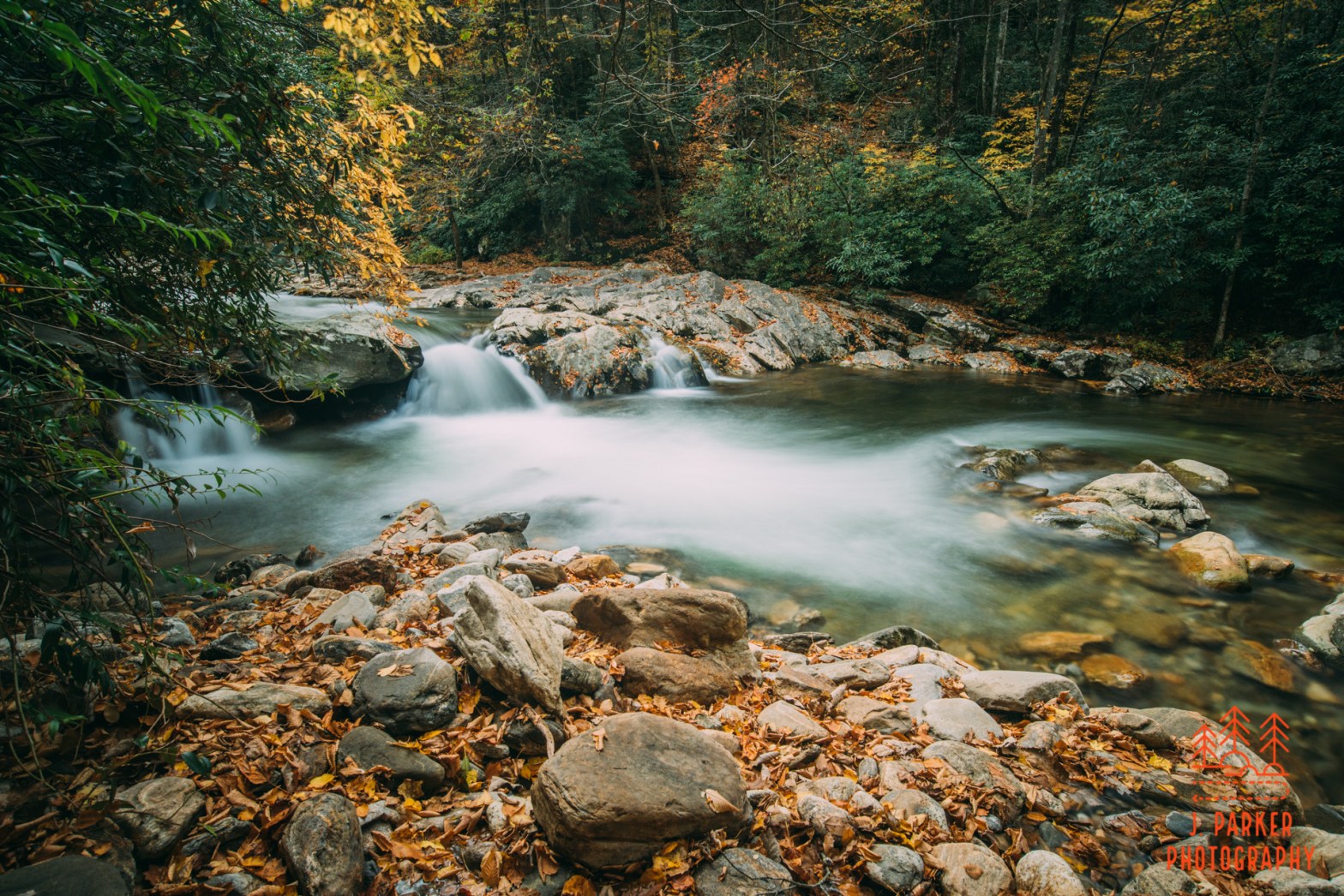
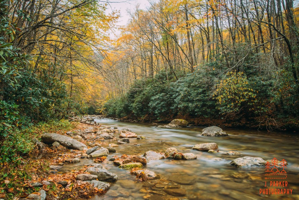
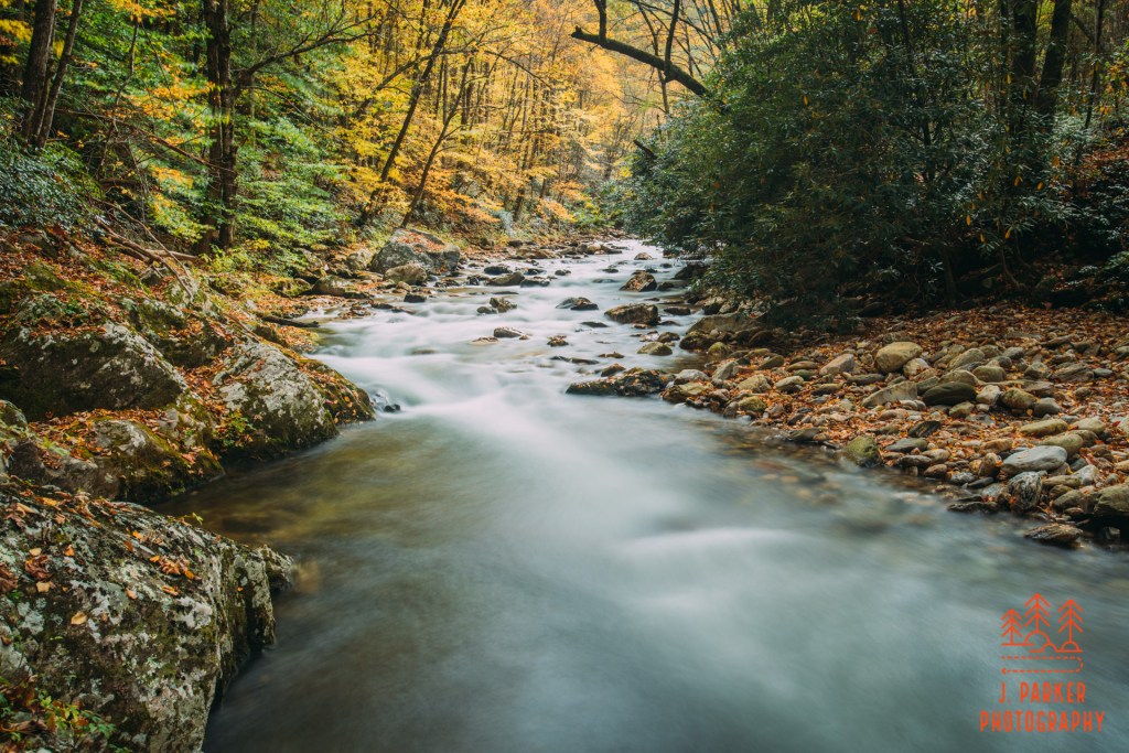
The next spot I got to was even better, and I couldn’t believe that what I had set out to find in this trip I had found in the first few hours at a place I hadn’t heard of until my Facebook friend randomly posted a picture of just weeks before the trip. A beautiful set of rapids, amazing orange fall color behind, with rocks decorated with fallen leaves, I was currently living a dream. At this next spot I was finally able to setup without venturing far into the creek, though it took some work to balance on uneven wet rocks and get my tripod setup. This time I was able to unleash the nd1000 in its full fury, dialing up 15 and 30 second exposures which caused the water look I really consider my trademark.
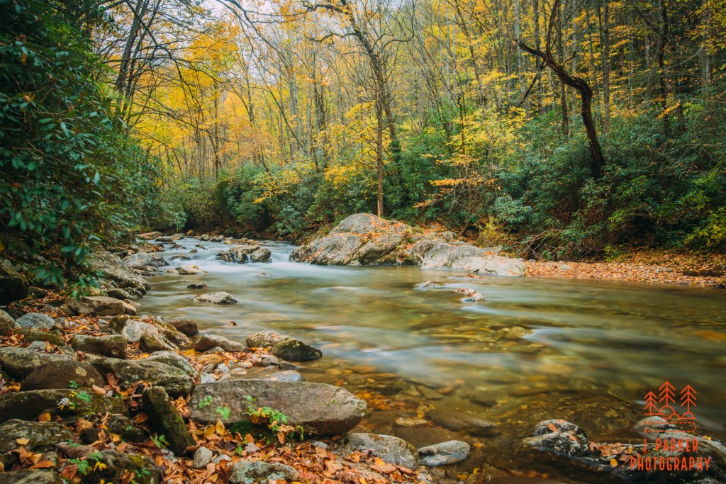
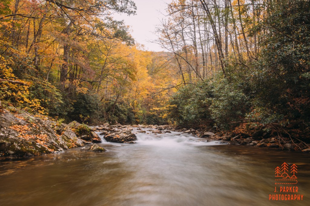
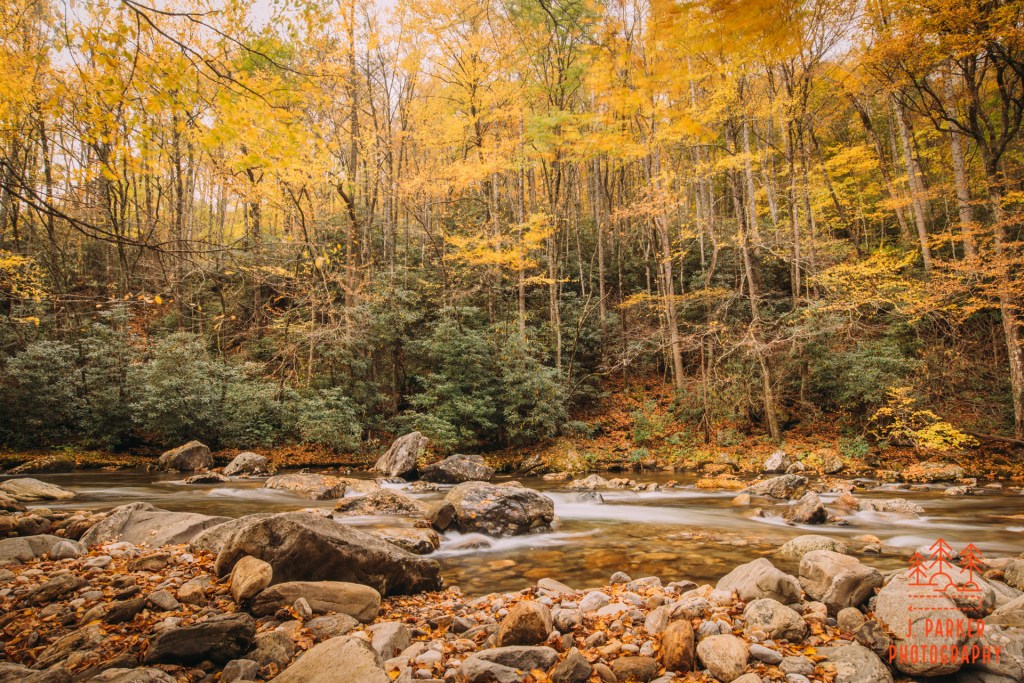
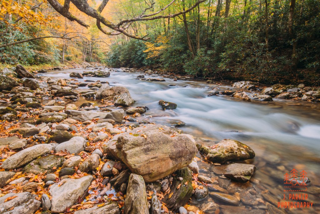
By now the trail was beginning to follow the river, really just an oversized creek, fairly closely. I didn’t have to take offshoot trails hoping that the spot it took me to would be photogenic, instead I could climb down where I could see fit. And in some cases I got a nice window between the trees to the river. While I like to balance things out with beautiful vistas and elevation that really highlight the fact that you’re in the mountains, and not Florida, this was my ideal trail; a nice walk along a rapid-filled waterway. The trail itself to this point was a nice, pleasant walk through the fall forest, but that was little more than an afterthought compared to what was happening in the river.
My biggest obstacle now wasn’t access to the creek or nice spots, it was the wind. A light breeze was rolling through, making the leaves jump back and forth. This made taking a long exposure a bit of a challenge, for at best with a breeze you’re going to get a shade of motion blur that make leaves appear out of focus, and at worst your trees are going to turn into patches of blurred color. Seeing as the leaves were a pretty integral part of capturing the season, that was going to be a challenge. At my next spot I really tried to time my shots to where the breeze would calm down, but as there is a two second delay before every long exposure starts (to avoid you hitting the trigger causing camera shake), and then however long your exposure is, it’s hard to time things right. There were no 15 second exposures here, just trying to capture a single second of relative stillness took work.
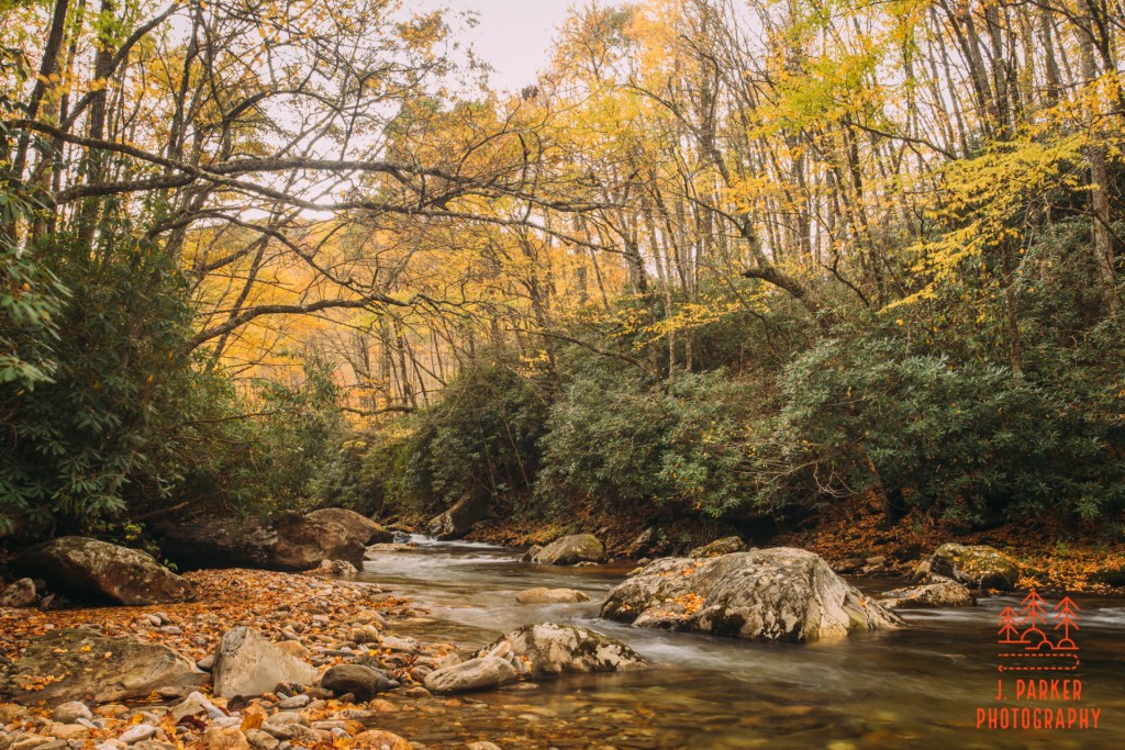
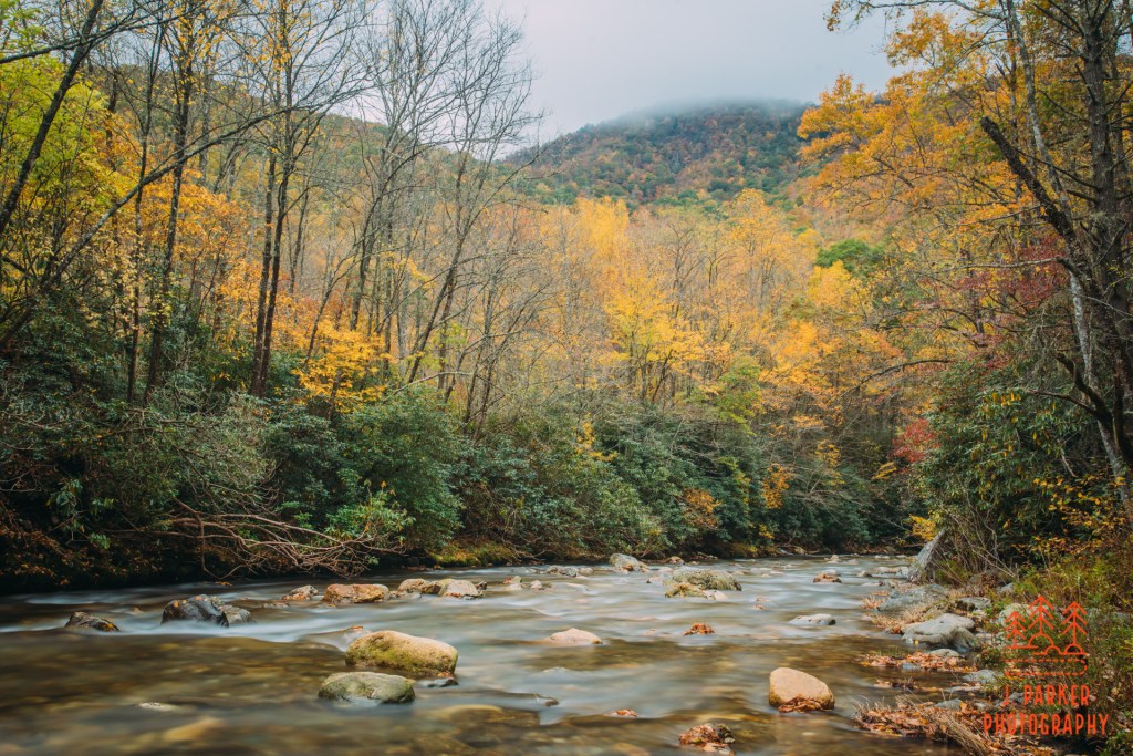
Streaming light was starting to become another issue. I was getting to a point where the ridgelines weren’t blocking whatever sunlight there would be, and the sun was beginning to peak out. Every time I shot upriver, which is my preferred way of shooting, I had to deal with a lot of light in the background, and carefully frame everything to minimize it. That was a bit of a shame, as the river was at its narrowest here, sometimes being just 15-20 feet wide, a far cry from where it was further downriver.
By now the trail was clinging tightly to the bluff hanging over the river. It made for a really fantastic place to walk. I was quite amazed that this trail I was hiking was just miles from some of the busiest hiking along the Blue Ridge Parkway and in the Pisgah National Forest, and that it featured such great sections, yet it was so under the radar that even a person who is decently well researched on hikes in the area and who dreams of creek and river walks had only found out about it by random chance of a friend posting it on my Chasing Carolina Mountain Creeks facebook group. I’ve hiked much more popular trails that had just a fraction of the beauty of this one.
While along the bluff I came across one of my favorite spots, where there was a perch above the river that let me photograph an elevated view of some rapids from above. I had to frame carefully but I managed to get a good 15 second exposure with my nd1000. As you are probably aware from reading, I spent quite a bit of time using filters, which you have to remove from the camera after usage if you want to do general shooting while walking (sometimes I hike with two cameras around my neck so I don’t have to remove the filters). Whenever possible I hike with a pocketed jacket where I place my glass filters, often without a protective case, for easy access. Its hard to cover much ground without taking some expedient measures, and covering ground quickly was necessary when you are only gonna get a few hours of ideal shooting weather over an entire 5 day trip. Without much thought I got my best shot and then placed my filter in my pocket, hoping to access it again soon.
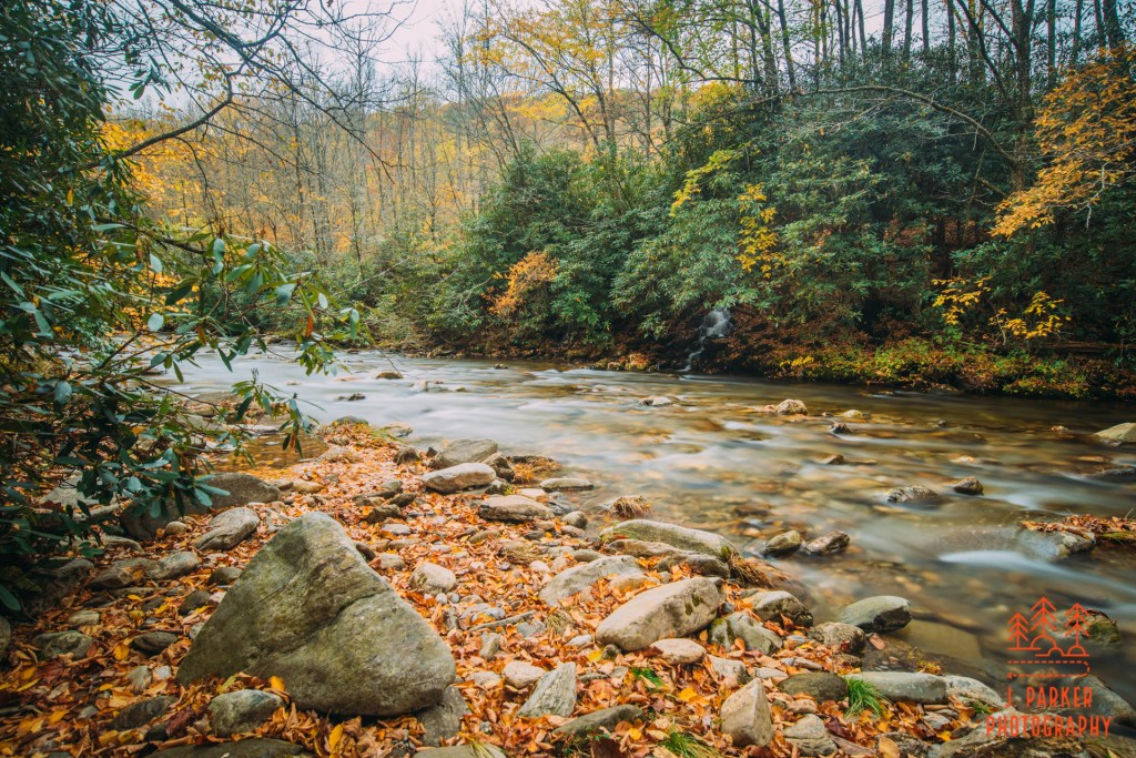
Ahead was a split in the trail. It seemed obvious the actual trail went to the left, but another fairly well defined path kept along the river. Naturally, I followed the path along the river, and it quickly led to maybe the most beautiful spot along the trail, which was were a small cascade tumbled into a wide pool outline by rocks before the river flowed away to the left in a small channel. The pool was not only photogenic, it also seemed like an idea spot to enjoy a summer swim. I’ve no shame in my enjoyment of summer swimming holes, as being able to safely swim in just about any body of water is something us Floridian’s, who always have to be conscious of gators, and whose water (aside from springs) is often brown and fetid, is a luxury we don’t get to enjoy. As this spot was roughly a mile from the trailhead, I could totally imagine returning here with my wife on a trip during the warmer months just to enjoy the swimming hole.
By this point the sun was coming in off and on like a strobe. I was going to have to wait for the light to dim long enough to get a good shot, and in the meantime I’d try to perfect my frame. As I explained before, I didn’t have to greatest balance on my feet at the time since I’d been largely immobile due to my hip problems. Thus, instead of trying to navigate the rocks on foot, I tended to “scooch” a bit on my butt and go from rock to rock. While doing so here and I heard a dismaying crack as my jacket pocket drifted under me. In my efforts to be sure I didn’t break myself, I had forgotten not to break my filter. I wouldn’t be taking any shots with an nd1000 for a few days, not until a new one arrived, though with the way the weather looked, I might not be taking many ling exposures coming up anyway.

From here, I retraced my steps back to where the trail had diverged from the river. And here was where leaving my trail information in the car was going to hurt me. See here I could tell that the trail left the river for a bit. What I couldn’t tell was where it was actually going. I followed the trial for a bit but it kind of disappeared for a while, being replaced by a creekbed which, for some reason, seemed to make more sense than whatever trail disappeared somewhere that I couldn’t even tell. After a combination of creek and whatever path seemed to make sense I ended up at a larger creek the one I had been following, which tumbled downhill for a bit. I wasn’t as close to the river as I would have liked. And I wasn’t even that sure where the right trail even was at this point.
It was here that I decided to start heading back to my car. It wasn’t that I was ending what was supposed to be a long hike due to not being able to find my way. Inability to find my way just confirmed what I should be heading back, for I never really intended to spend the entirety of my hiking day at Big East Fork to begin with. The sun that I knew would show up eventually had arrived in full force. I was just about ten miles from some of the best hikes in North Carolina, ones that would be perfect for the unblemished sunlight that would be occurring for the rest of the day. So I was always planning on heading to one of those hikes to finish off my day, and losing my way a bit just reinforced that.
I was very satisfied with my short time spent along the Big East Fork. Had the day promised a more cloudy weather I could imagine having a very satisfying longer journey along its southern bank. In an area where trailhead parking lots are regularly at capacity, it’s a nice option that remains under the radar and hassle free. In the summer, it offers at least one good place to have a dip, and in the fall, there’s definitely some nice pockets of color. It wouldn’t hurt, though, to remember to grab whatever trail directions or map you planned on bringing with you from the car.