I was almost through it, the stacks of boulders the size of modern day pickup trucks that tow mobile homes behind them just for the sake of justifying them costing more than my house. I had navigated foot by foot along the treacherous stretch, having to take care to avoid a spill and concentrating on my every last step. And then I heard it, a loud cry broke through the air. Jess was about twenty feet behind me, and she hadn’t made it through quite like I did. That cry was her turning her ankle on one of Grandfather Mountain’s ancient boulders. Fortunately she didn’t lose her footing (she’s practically a professional at turning her ankle), but she was still going to be in quite a bit of discomfort for the remaining two days of our trip. Lesser hikers might have turned around in that moment, admitting that Grandfather Mountain was simply too much for them and returned to the safety of parking lots and swinging bridges with sweeping views, but not us.
We had turned around some time ago.
We had come face to face with maybe the most infamous rugged hike in the southern Appalachians and said “not today, Satan” (He shouldn’t have been that upset at us canceling our plans with him. We visited his cellar at Table Rock the day before). I had evaluated the reward of completing yet another awesome mountain hike versus the risk of dying, which seemed to be quite a bit more than normal, and after crunching the numbers I decided that death would probably put a big damper on our trip, for if I died the chance that my pictures from the trip, including the 5 days of hiking we had already done, would likely never get seen. There was no purpose on going on a trip if I couldn’t share pictures, so I had to avoid death for the time being.
My fear of death didn’t just come about on its own. There was a particular moment where I was using a cable to navigate an ascent, and as I reached the top of the ascent I realized that completing it would require a difficult detach from the cable while on a small sloped rock with little safe purchase. Though I’m certain a fair number of people navigate it safely, as I couldn’t spot any corpses nearby in my field of vision, I had doubts about my ability, mostly because a)I’m from Florida and b)I was wearing a camera bag that sat awkwardly on my back. This heavily threw off my sense of balance, which I’ve found to be crucial when trying to perform acrobatics on the edge of a sheer dropoff. And that was just myself. The gentleman in me (there is still good in me. Luke Skywalker can feel it) couldn’t fathom asking my wife to try to navigate that either. So I returned the way I came, not the least bit disappointed that I was going to leave a signature hike unfinished.
I had basically decided beforehand that we weren’t gonna kill ourselves trying to do this hike if it were above our heads. Our plans had changed, as I had had to drop South Mountains State Park from our itinerary after realizing that Floridians who are uncomfortable driving mountain roads after dark simply wouldn’t be able to do that park and Linville Gorge in one day. That allowed us to start exploring the Grandfather Mountain area a day earlier than anticipated. It also opened up the opportunity to visit Roan Mountain, a hike that I was really excited about as it sounded similar to Black Balsam, a magical hike for me several days prior. Our minds were on Roan Mountain before we ever started the trek up to McCrae Peak. We were also really, really tired, having hiked six of the last seven days, with the non-hiking day including just as much walking around the city of Asheville. Tired bodies being placed in higher elevation than they had ever hiked before is simply not a good mix, especially when one adds the very real danger a hike like Grandfather can entail. I considered our foray onto the trail system more of a survey of what the hike was like more than an actual honest attempt at completion.
Our aborted attempt to reach McCrae Peak was actually part of a series of four stops we made along the greater Grandfather Mountain area, starting the day before, after we completed our fantastic Linville Gorge hike. Unlike other parts of the trip, we were on smaller stops rather than one big hike to enjoy the area. Rough Ridge, Beacon Heights, the Linville Gorge Plunge Basin, the Tanawha Trail, and other potential stops were all on the table. We were also looking forward to just getting a few miles on the Blue Ridge Parkway, as the only time we had been on this section of scenic drive (including the iconic Linn Cove Viaduct) before had been on an exceptionally rainy day. The rugged terrain of Grandfather Mountain itself, which is really unlike anything else in the area, gives rise to so many scenic opportunities. I had never heard of Grandfather Mountain before our honeymoon journey down parkway in 2011, but even in intensely rainy weather it was clear there was something special about this majestic mountain which houses many signature curves and views along the Parkway (we had been a little surprised and a little underwhelmed to find a lot less views than we anticipated along the more rolling hill-style Virginia portion of the Parkway. Grandfather Mountain was the first part of the road that really looked like we envisioned, minus the rain of course).
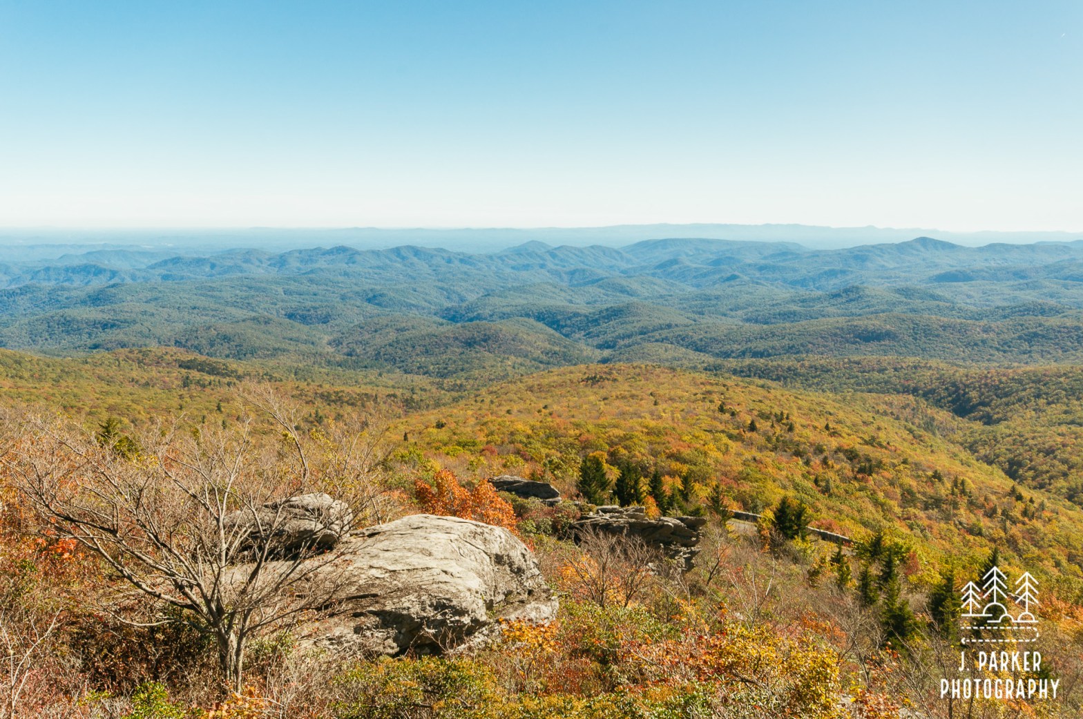
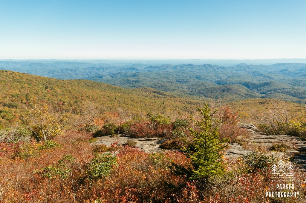
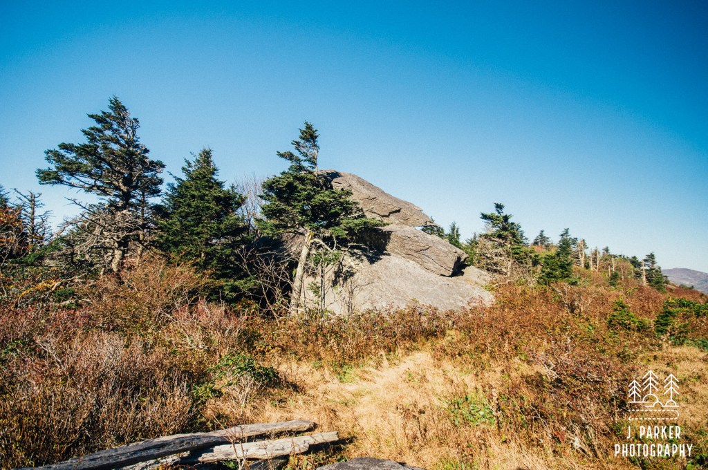
Rough Ridge was the stop I was most excited about, my one “must-do” stop outside of the park itself. My anticipation of Rough far exceeded the short length of the trail (at least the popularly hiked portion of it referred to as “Rough Ridge”, as it’s actually a part of the larger Tanawha Trail). The pictures I had seen of it in fall, with pure red leaves clinging to rocks along a ridgeline that seemed to tower above the numerous foothills below, seemed like something straight out of a dream. The casual hiking sites, of which there are numerous which cover the Asheville and Western North Carolina, had no hesitations about extolling its virtues. It had a romantic look that every Jack and Jill seek out, and that was fine with me, for I wanted that too. As a Florida boy experiencing his first fall, I wanted to step into those travel site moments and had no shame about it.
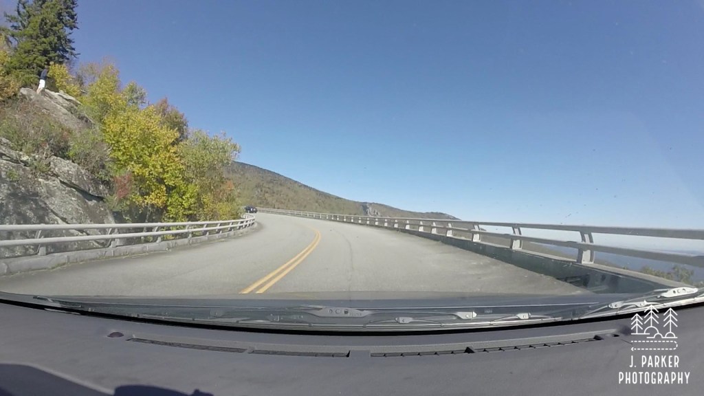
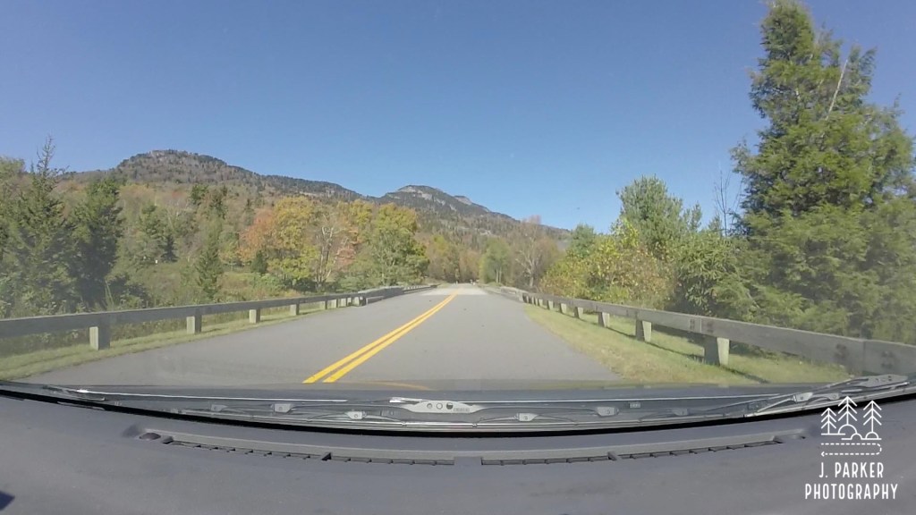
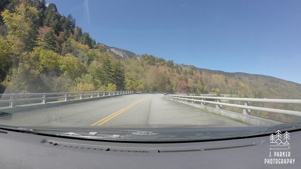
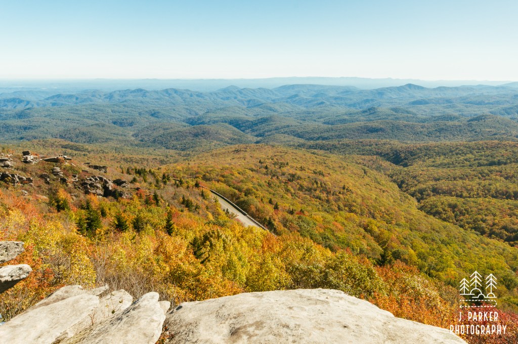
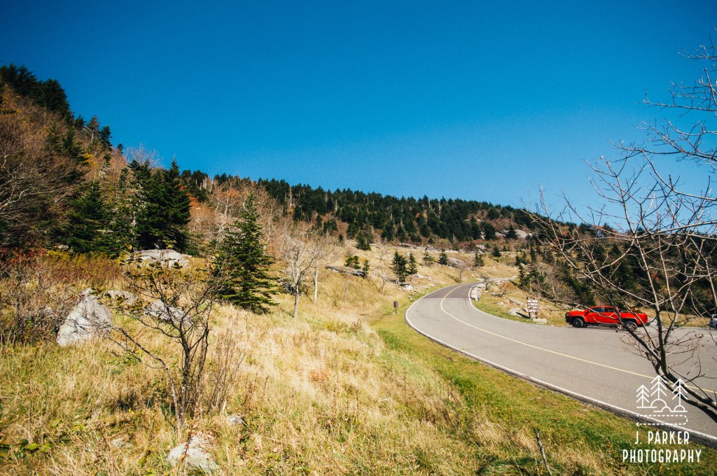
Starting Rough Ridge had the added bonus of being able to cruise that spectacular section of Parkway which traverses the lower stretches of Grandfather Mountain and the Linn Cove Viaduct. The weather was perfect for such a journey, with cloudless blue sky to provide clear views of the peaks towering above the parkway and those lesser peaks which lied to the right, far below the roadway. It was staggering to see the sharp contrast in elevations all within the same field of view. Sunlight glistened off the forest, which provided glimpse of every color nature could offer, from bright green to vibrant yellows to fiery reds. It was a sight to behold, and we were far from alone on this glorious day. Despite being a weekday, the area was filled with tourists like us, seeking the find the best of fall. We had to slow at times to avoid hitting pedestrians filling the roadway itself (at others we simply sped through them, careful to leave no witnesses). We began to worry we might not find parking at our desired spot; indeed some places around the Linn Cove Viaduct left not a space unclaimed, and parking would be a constant concern the remainder of the trip as the weekend approached. Through the entire drive, the enticing, dramatic peaks of Grandfather beckoned from above, with large swathes of its ridge being covered on the brightest of reds. Fortunately there were spaces available as we pulled into the trailhead that would lead to Rough Ridge, which came up not far past the Linn Cove Viaduct.
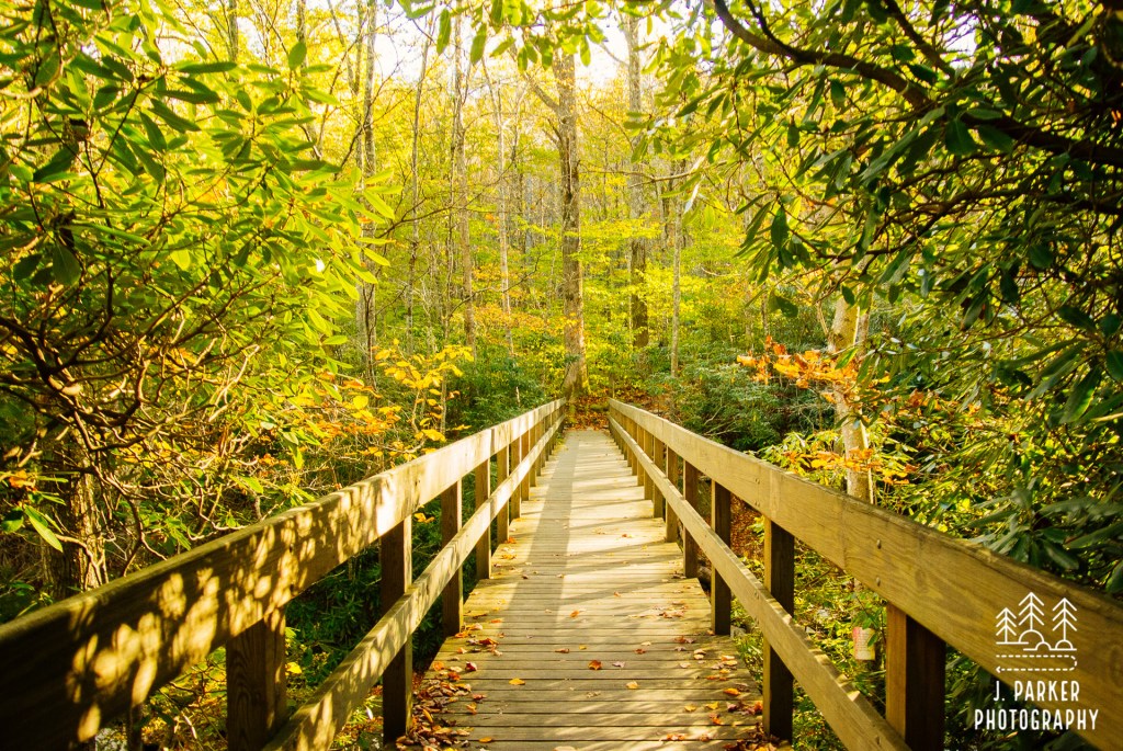
We started out on our path to Rough Ridge, but we started in a different direction than I anticipated – up. I had envisioned Rough Ridge being an area stemming off the Parkway downwards, for it seemed it would be that way in the pictures. This would mean a bit more climbing for the day after we had already done a hike at Linville Gorge. Up we went, for the trail started out climbing immediately and while the footing was far from abysmal, I certainly could easily see where the name Rough Ridge came from. Navigating the trail was often times stepping from one rock slab to another, with a myriad of roots thrown in for good measure. It was surprising in the sense that this trail was one heavily used by the general public, so I didn’t expect it to still be so rustic. Crossing a creek bridge provided a little change in scenery, and the trickle of water briefly supplemented the sound of the crowds and nearby vehicles on the Parkway. We really didn’t stop to take it in though, with the sun beaming in through the colorful leaves we were focused on the prize.
It wasn’t long before unfiltered light began to stream in, letting us know that the canopy was opening up as the brush along the trail transitioned from forest to shrubbery. A small flight of wooden stairs lead to a section of boardwalk. We were there – our first view from Rough Ridge.
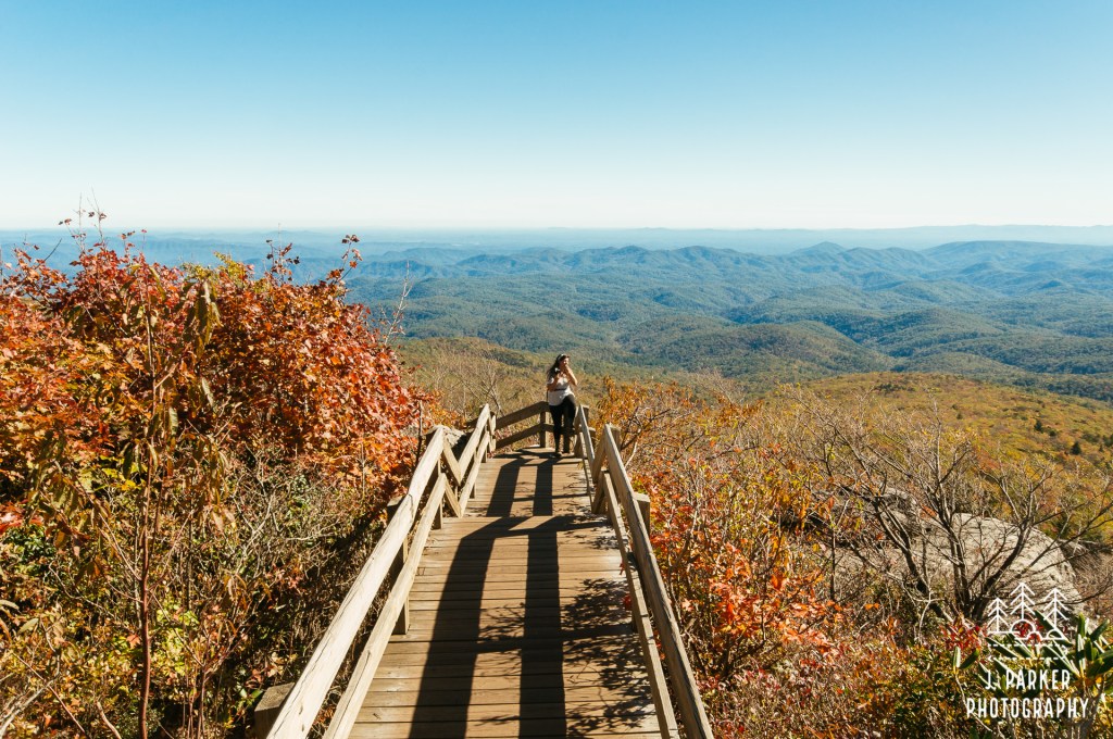
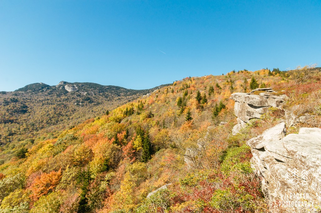
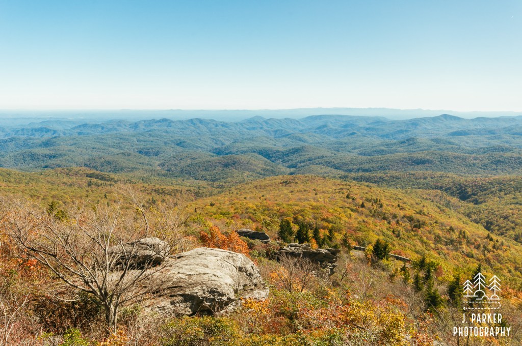
If it weren’t for some video clips, I may not remember much about the ascent up, and I only remember the tiredness of my body just because I spent the final three days of this trip feeling a fatigue that never left. I didn’t remember us nearly plowing into pedestrians on the Parkway, and hopefully they didn’t either, or at least didn’t get a good ID on the vehicle. But I will always remember how Rough Ridge looked this day. Immense boulders lay clinging to the side of the ridge, gradually escalating in height as the trail moved along. Most vividly, a multitude of shrubs covered the hillside, providing seasonal color that not even a dream would dare to create. Up top, you could see the always striking and distinct peaks of Grandfather Mountain. Looking down, it seemed as if you were perched upon a precipice on the edge of the sky, with so many ridgelines filling the frame below that it appeared you were gazing from a boardwalk out into the sea, with the innumerable ridgelines each being mere waves. Never was the magic of the Blue Ridge more present than this, when a pleasant blue emanated off the mountains, almost merging the beauty of the awesomely blue sky with the land below.
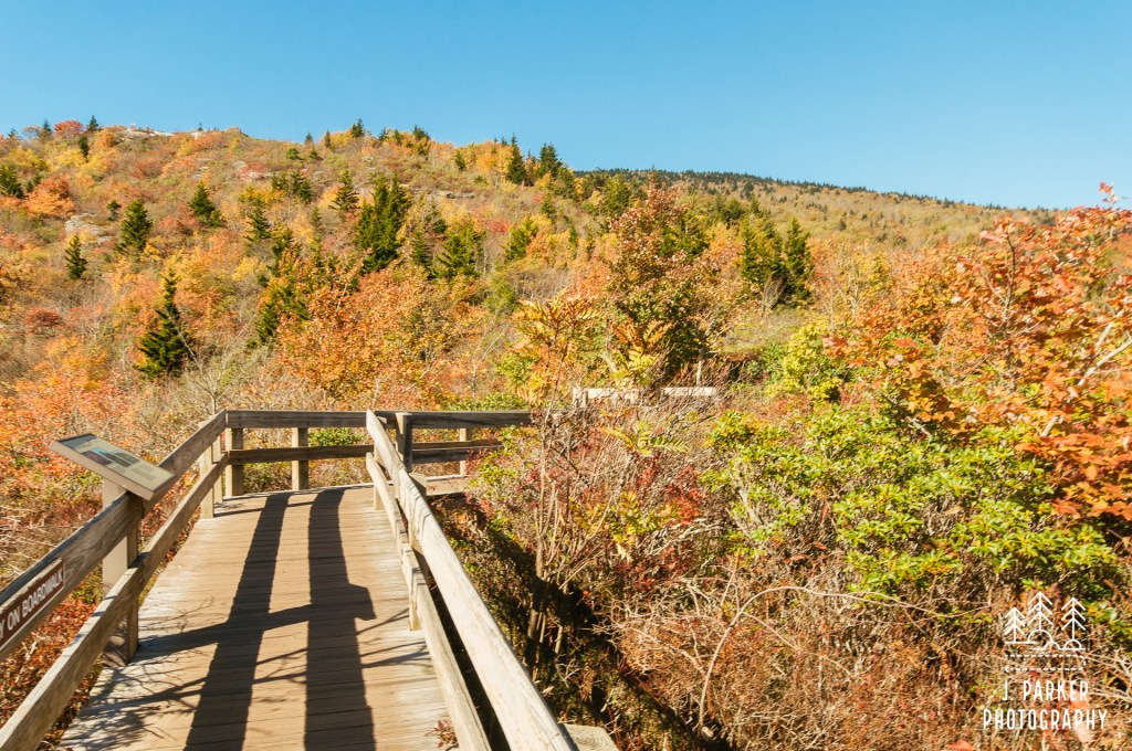
Rough Ridge wasn’t a singular outstanding view or point, it was a constant series that kept you in anticipation of what lied at the next rock. The boardwalk opened up many times to boulders, allowing for free walking and in many cases, climbing so you could find your own perch. There were dozens that perched quite naturally on steep rocks. I tried to echo them and found it wasn’t near as easy as they made it look. In fact, sometimes I found my rock perches quite terrifying and not all secure. I enjoyed the view though.
It’s rare that you visit a place at the perfect moment, where the brush, the lighting, and the vegetation match the scene perfectly, and capture the mood that the travel sites want to make you think you’ll see all the time. Believe me, I’m a photographer, and though I plan to catch places at their best, even scientific guesses don’t result in perfect timing. On this day, however, Rough Ridge could simply not have been any better. Everything was optimal, and while the walk to Rough Ridge was indeed short, it packed in more beauty in that time frame than lengthier trails like Looking Glass Rock could do in seven miles. I’ve said more than I imagined I would in regards to what was, in actuality, a fairly quick stop we did. But the tremendous scene merited some time discussing, and I’ll leave Rough Ridge with a few more pictures.
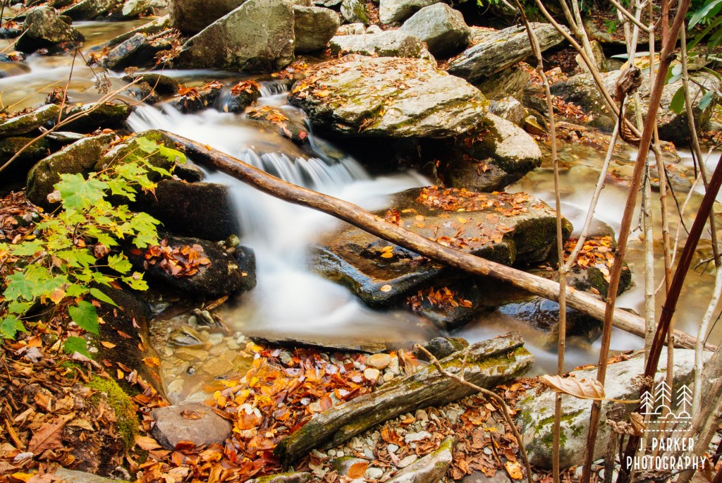
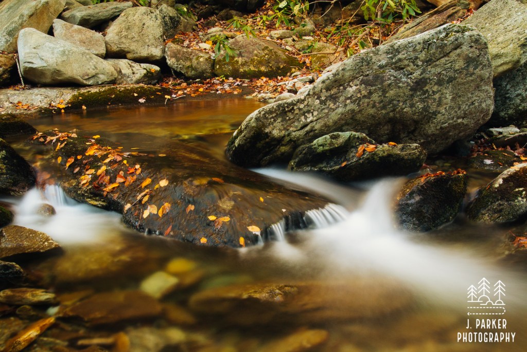
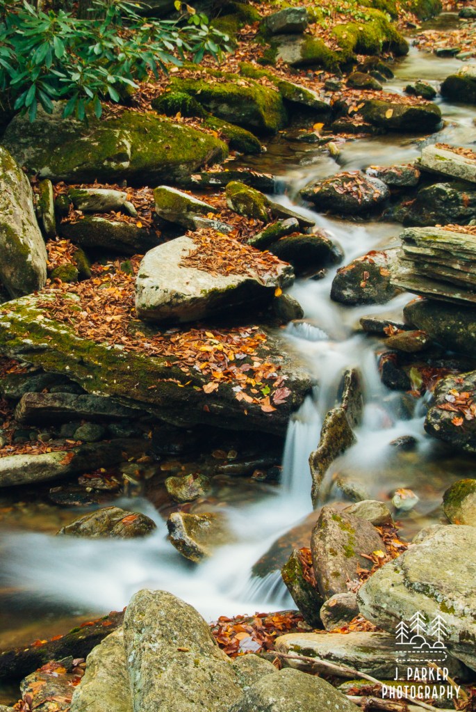
I can’t remember what less us know it was time to turn around. Did we reach a point where it seemed there were no more rocky slabs to take a view from? Was there a sign that said “Rough Ridge over”? I don’t know, but we did retrace our rocky steps back to the car. It was far closer to dark than one might think from the pictures, and I wanted to find a nice creekbed to photograph during golden hour – hoping some fall foliage would put the “golden” in the term. I knew of one – Boone Fork – for I had seen enticing pictures of it recently. I just didn’t actually know where it was. Oh, I knew where to find the creek. Several places I could find it in fact. I just didn’t know which location provided the cascading rapids surrounded by fall color I had seen. I took a good guess on it being located along another portion of the Tanawha Trail, and not at the actual Boone Fork Trail, but I wouldn’t know if I was correct until it was too late to turn around.
We drove at a fast pace towards the desired trailhead, and kept that pace working our way the short distance to the creek crossing. As we neared the bridge, which provided a wide, elevated crossing of the creek below, the scene was bathed in golden light. I had to work my way ahead a copse of tropical foliage, but once the vegetation had peeled away it revealed the scene I had been seeking out. Well, almost. The pictures I had seen hadn’t contained a frolicking older couple some twenty to third yards upstream. They were going to be a challenge to photograph around, much to my chagrin. But the rest was splendid, with the creek steadily cascading over a series of rocks covered with fallen leaves while striking oranges and yellows shined brightly in the afternoon sun behind. The human activity behind me kept me from capturing the scene fully in an immersive photograph, but I did what I could to capture some nice scenes when I had the chance. Enjoy the series of Boone Fork pictures below.
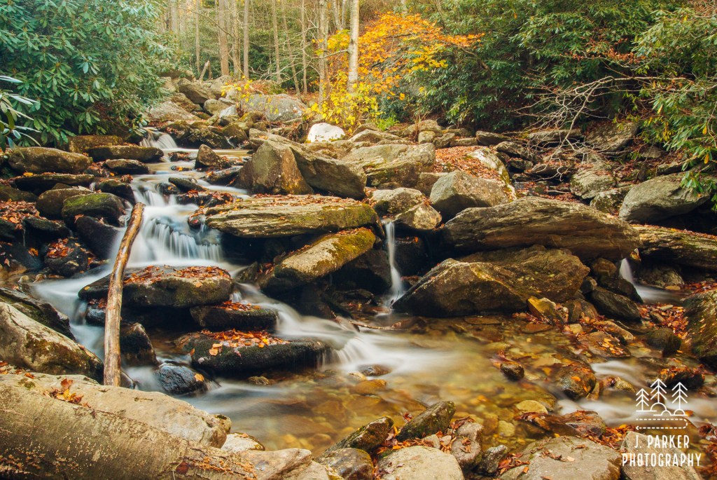
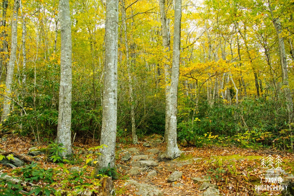
Before leaving, a walked a short distance on the other side of the bridge, taking note of the varied shades of the woods on the opposite side as the Tanawha Trail continued further along its passage of Grandfather Mountain’s lower reaches. I had no regrets about how we had spent the afternoon, but I knew that where I was at then was a starting point for some great hiking, either hiking the full Tanawha Trail itself, or using a the connecting trails to make an ascent of Grandfather Mountain from below. I wondered what type of experience we would have had if we had done one of these longer hikes and how different it would have been from what we undertook.
After an overnight sleep at a nearby hotel, we awoke to find our vehicle coated in a thin layer of ice. Coming from Florida, we were fortunate to have this be the only time the temperature dipped below freezing in our week in North Carolina, for we were ill prepared for ice. Luckily the ice on the car was thin enough that it melted off rather quickly, which is good, for I discovered on a hiking trip a few years later that I had no idea how to remove ice from a vehicle’s glass surfaces. We were ready to start our second day in the Grandfather area by heading to the namesake park itself, but it wasn’t ready for us – at least not at 8AM. I had gotten the opening time. In the meantime, we were just minutes from Beacon Heights, a short hike to an overlook along the Blue Ridge Parkway. Though this would be our first attempt at it this trip, it wouldn’t be our first try at reaching this popular overlook. Our 2011 honeymoon journey down the Parkway had been marred by poor or non-existent signage at almost every turn, and Beacon Heights became the epitome of that. In between rain bands on that stormy day we attempted to reach the overlook that had been so widely lauded, but we were surprised that our short walk was quite longer than anticipated. Eventually we ran into a group of back packers that confirmed our suspicions that we had gone the wrong direction. I can’t place fault entirely on myself though – only on our return trip did we see a solitary post, missing the sign it was supposed to hold, with an arrow to Beacon Heights literally penciled in on the bare wood, almost imperceptible. We didn’t have time to go the right direction, so we missed this one.
As we approached the junction on this cold morning I noted with great glee that a beautiful sign had a clearly marked arrow to Beacon Heights (signage was fantastic all along the Parkway in 2017. We seemed to have hit it at a low point in 2011). Onward we walked on the short path which formed the end of the Tanawha Trail, passing large boulders along the way. In a short time our numb bodies upon the flat slab of rock with a steep dropoff on one side which forms the Beacon Heights Overlook. After first attempting to visit the overlook six years prior, I was actually a little disappointed that the view was just average and, except for the fact that you had to hike to get to it, which makes views innately more enjoyable, it didn’t provide anything that couldn’t be seen from the Parkway and its pull-offs nearby. One must bear in mind this review is coming from somebody who just the day before had seen outstanding views from Table Rock, the Chimneys, and Rough Ridge, so I wasn’t easily impressed at this point. We didn’t stay too long to savor the views, for we still wanted to get to Grandfather Mountain when they opened.
We returned to the gate for Grandfather Mountain and joined a small line of cars that were waiting for the park to open. As we were stopped we saw a deer conspicuously dash across the roadway into the park grounds. He appeared oddly similar to someone who was in a rush to get to work on time, especially since he made his appearance just before the opening time of the park. With a small grimace we paid the $20 per person to enter the park, but we couldn’t complain, as we made the decision to visit knowing the cost beforehand, having passed through the area once before and left with wonder as to what the park might be like. We started our way up the park roadway to the sounds of the audio tour on CD provided by the park (this CD stayed in my wife’s car for months, maybe years afterwards, piping into remind us of Grandfather Mountain’s virtues at random times. In fact, it may still be in that player, as we’ve progressed to streaming bluetooth from our phones). With great amusement, the CD described the wildlife present at the park right as we passed a very familiar deer having a morning meal just feet from the road. He must have been late for work after all!
On we went along the roadway as it wove a serpentine path higher and higher up the mountain. At first much of the roadway was wooded, but as we ever further, passing facilities such as the park restaurant, eventually there was nothing but sky and open views along the road. We were heading to the very top to enjoy the park’s signature attraction in the mile high swinging bridge, which would be a great platform for sweeping views on another terrifically blue sky morning. As the elevation changed, so did surrounding vegetation (aside from ts unique ruggedness, Grandfather Mountain also features exceptional biodiversity), eventually landing us in an evergreen forest the likes of which I hadn’t seen since visiting the Smokies two years ago.
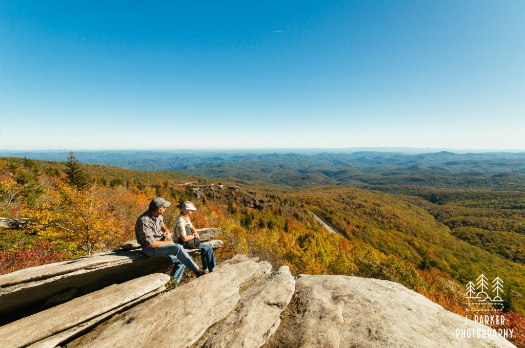
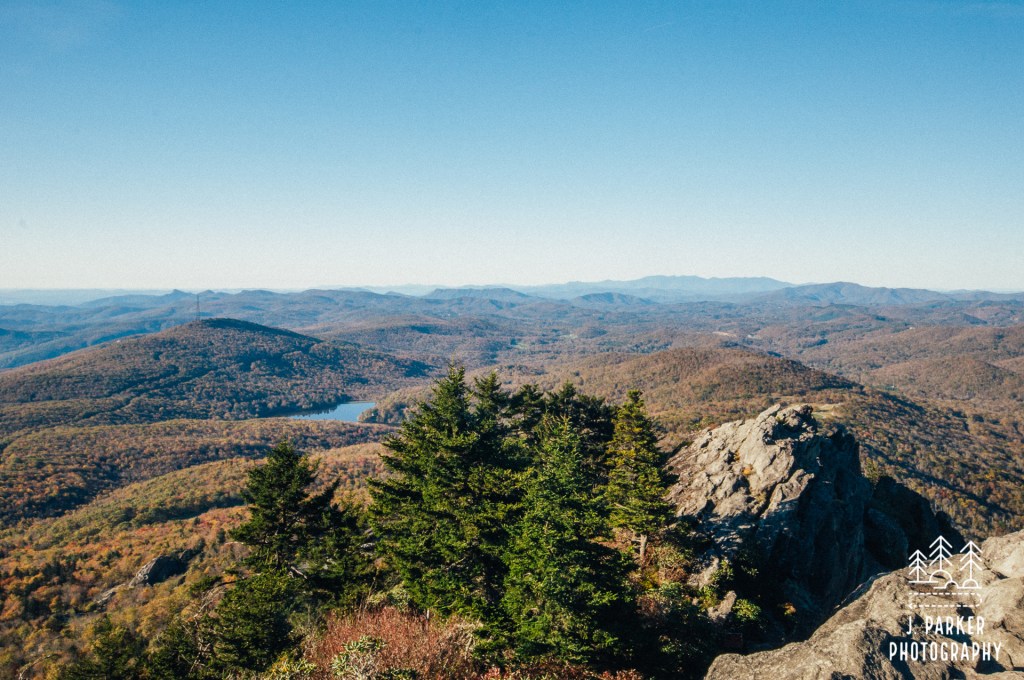
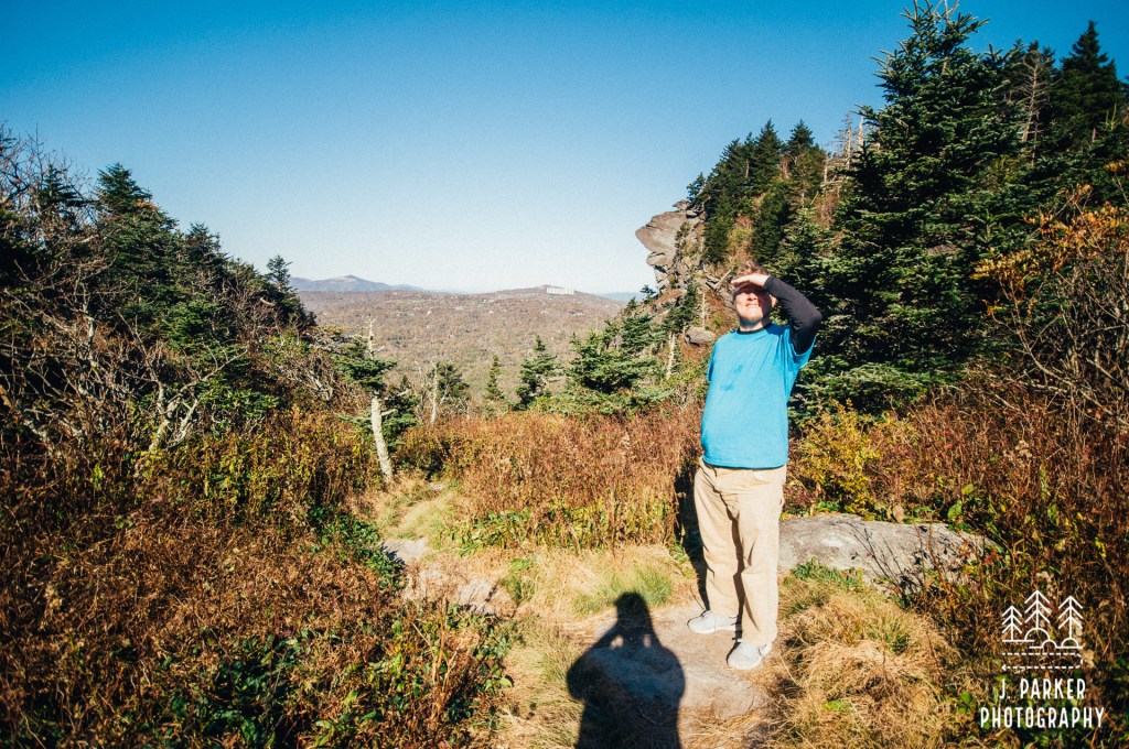
Awaiting at the end of that climbing drive was a parking lot next to a stone structure and stairway that formed the entrance to the swinging bridge. We eagerly walked up the staircase, happy to be practically the first people on the bridge that fantastic morning. Towers, much like you’d see on a notable bridge over (troubled?) water, anchored either side to the ground as the bridge spanned a large chasm between the parking area and another subpeak of Grandfather Mountain. The towers provided an added ambience to the scene. The swinging aspect of the bridge mattered little to me; unless there is legitimate risk of falling I’m not unnerved by heights alone. What did matter to me was how good the view was, though I found the best views weren’t necessarily from the bridge itself, but rather when one looked back towards the rugged peaks of Grandfather’s main ridge with the bridge in front of it. The exposed rock, which reflected a light, white hue from far away, and the evergreen forest framed by the blue sky almost made the scene appear alpine. I can honestly say I never saw anything similar to that elsewhere in southern Appalachia. The subpeak on the opposite side of the bridge was a fantastic place to explore, with a lot of rocks that were flat enough to allow one to comfortably enjoy the sprawling view ahead. Far below there was the view of a lake, behind which stood Grandmother Mountain, and then farther back was a glimpse of the notable peaks and along the eastern rim of Linville Gorge, like Table Rock, which we had visited the morning before, and also the hint of a glimpse into the Linville Gorge itself (the Linville River which forms the gorge traces its source to Grandfather Mountain). And behind that stood the wide crest of the Black Mountains and Mt. Mitchell, tallest in Appalachia. That would be our destination the next morning. For now, we were savoring the awesome view before us.
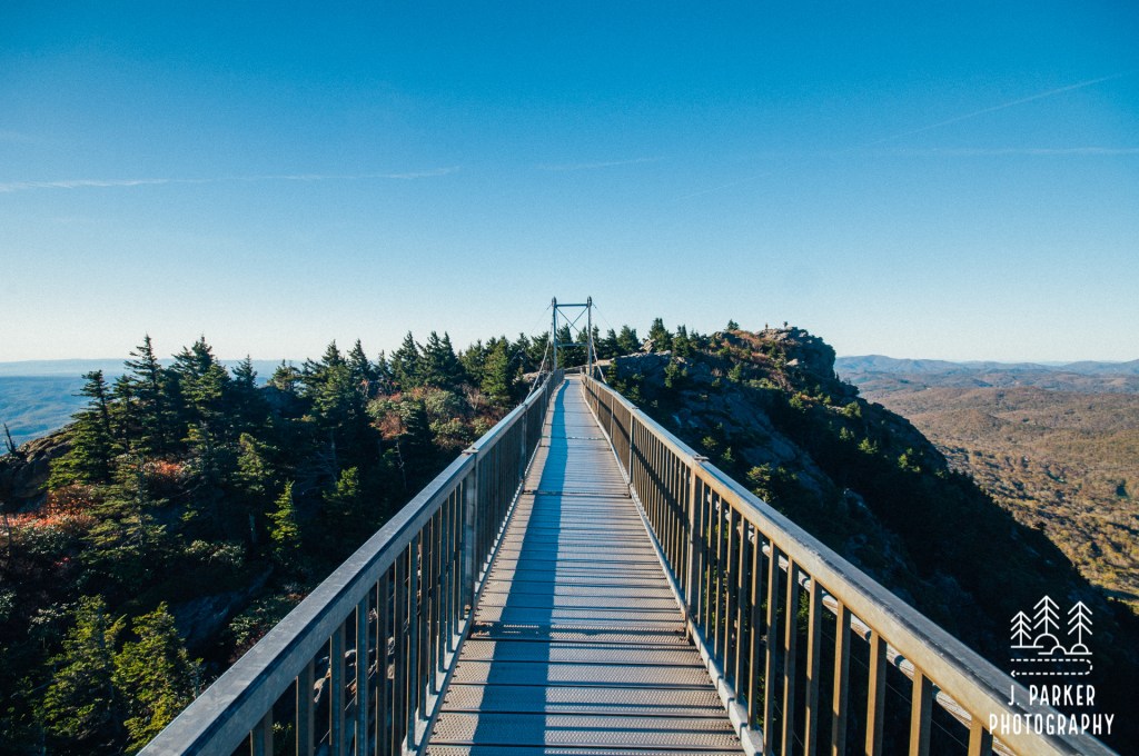
There’s a funny thing with views – when you can drive and/or take a short walk to one, they never really resonate the same as if you had obtained a view in a more organic way. That view from Grandfather, obtained so easily by parking and crossing the swinging bridge, may have been one of my favorite views had it been one I had to hike to reach. As it was, it’s hard for me to judge it compared to views that were much harder won. The only hard thing about these views was having to pay $20 per person.
It’s a funny juxtaposition, going from a tourist trap style attraction to hike some of the most challenging terrain in the southeast, but that’s what we did. We had to drive back down to a lower parking area, where we were to start on the 1.2 mile journey to McRae Peak. We didn’t find it exceptionally reassuring to have to complete permits at the trailhead, having already adopted the mindset that this was gonna possibly be over our heads. The trail opened up rather flat, but despite that the path mostly navigated from one rock to another, providing a great opportunity for twisted ankles. Never one to miss out, I twisted my ankle on one of them within a few hundred yards of the car. It wasn’t a major twist, and as a former cross country runner I’m quite accustomed to twisted ankles, so I didn’t even mention it to Jess when it happened. It wasn’t going to stop me from hiking, but hitting the trails for the last two days of our trip kept that ankle weak and hurting a bit for a few weeks even we returned home. Still, it wasn’t a very promising start.
At least for the beginning of the trail, as we worked our way up the .6 mile connector to the Grandfather Trail, there wasn’t much in the way of great scenery of offset the difficult passage. That .6 mile stretch felt way too long, with the constant need to watch footing as our tired bodies ascended the fishhook-shaped trail. My pack felt heavy, and it certainly was heavier than it needed to be, as I brought my large DSLR camera bag on a hike that would have probably been well captured by the mirrorless camera. The only advantage to taking the DSLR pack was having room to bring a snack and drinks, but had I thought things through, I would have realized I could have done the trail, which overall was only a couple miles long, without supplies. We weren’t exactly at threat of dehydration on a day that couldn’t have topped 60 degrees and started the morning below freezing.
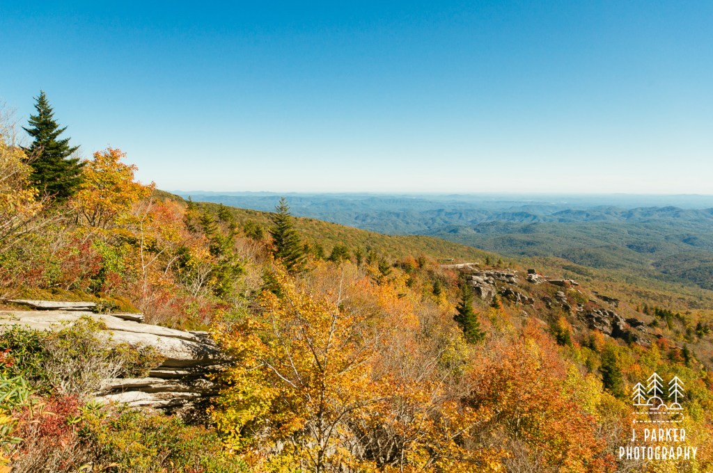
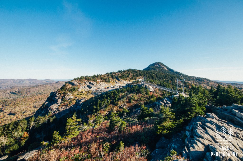
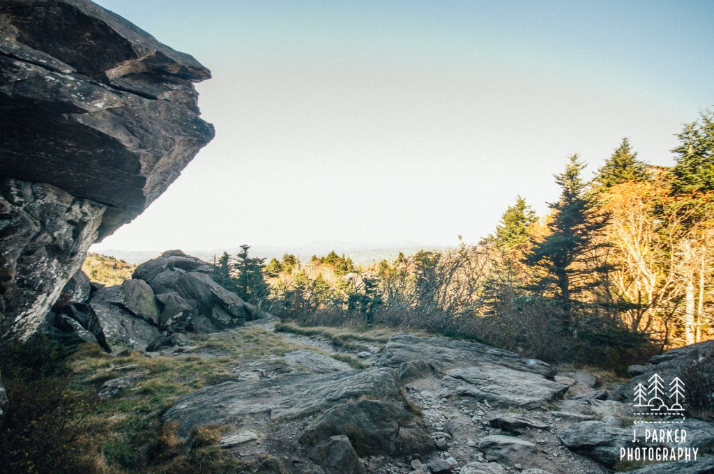
As we neared the connector we started to get a bit more to see, as the trail navigated along and sometimes between house-sized boulders. We got a little pop of a view as the trail opened to the south, though this wasn’t anything compared to what we had seen just minutes before near the swinging bridge. There was a more interesting view once the trail started angling directly towards McRae Peak, placing its prominent knob in direct line of sight. It had been impressive when viewed from the swinging bridge, but now that you were actually hiking to it the peak became ever more impressive, if a little intimidating.
After passing that view of McRae Peak and navigating along some boulders, the trail leveled for a a bit, eventually reaching a spot where we got a small opening in the ridges to the north. This was the first view we had gotten of that direction from Grandfather, as until now the crest of the ridge had blocked our view to the north. It wasn’t an overly impressive view, but having the view at all made for a brief respite from the onslaught. That sense of calm didn’t last very long.
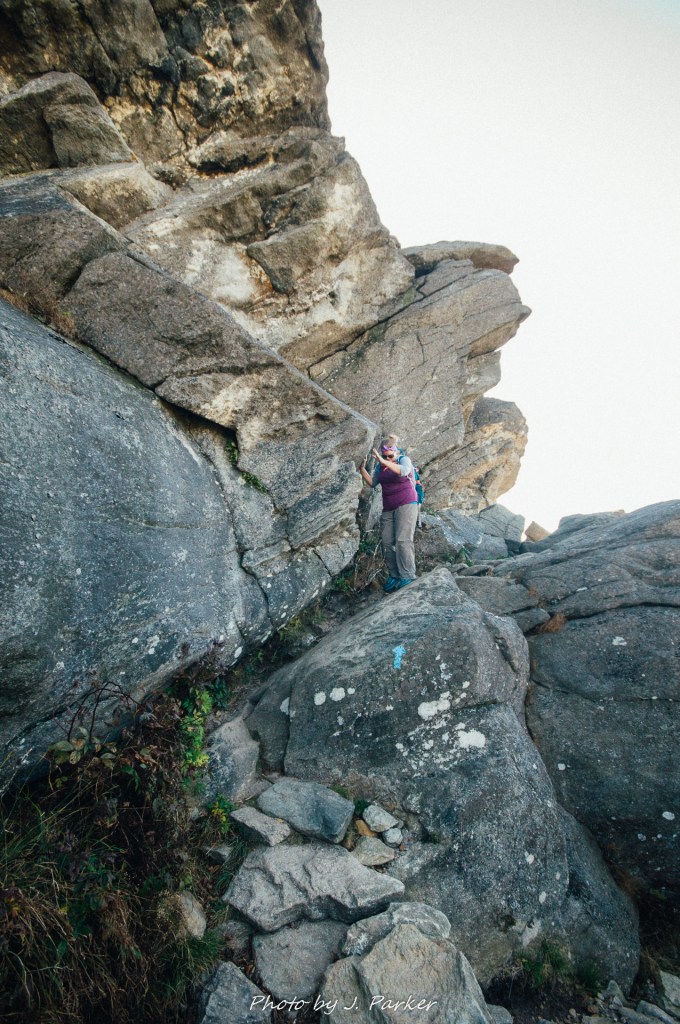
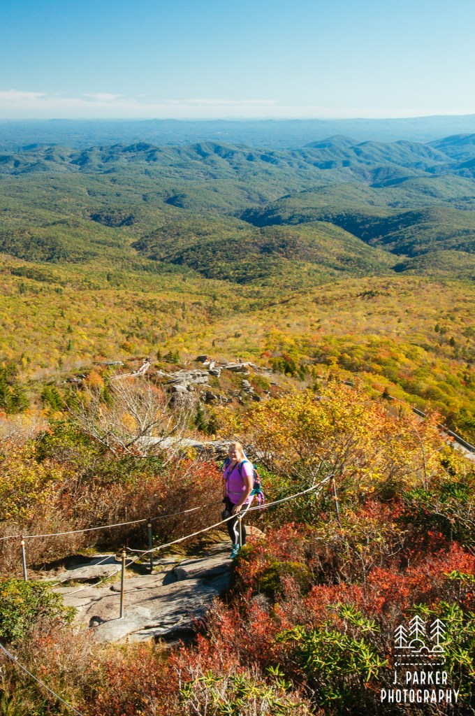
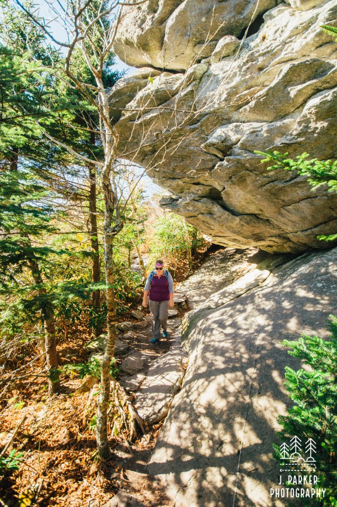
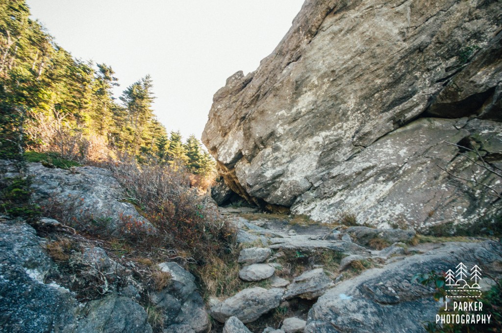
We next embarked upon the rockiest section we had navigated yet, where a narrow path barely made its way between the shrubs as a jagged palette of rocks formed a winding staircase whose end always seemed to be obscured by the shrubs. Perhaps that was a good thing, for the end of the winding path was the beginning of a truly daunting rock scramble – the same one highlighted in the beginning of this write up. A large rock face loomed to the right, and a jumble of boulders of all sizes and shapes sprawled out beneath it. Faint blue markers occasionally visible on the rocks let you know you were supposed to cross these rocks, though how wasn’t always clear. It took a bit of contortion to navigate this passage that I would call a hellscape, except for the fact that it had a certain amount of beauty to it. Us Floridians have found it optimal to slide on our butts through these portions whenever possible.
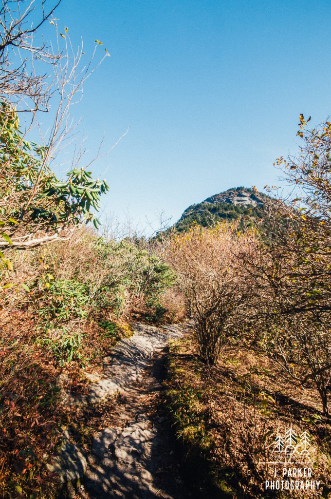
On the opposite of the boulder field was a brief respite, where there was a pleasantly flat section that formed a small meadow enclosed by boulders and evergreen forest. A sign in front of a wooden fence told us that this was Grandfather Gap, a unique and fragile plant community. The flat section was brief, and another significantly rocky ascent reminded us of Grandfather’s true nature. This ascent housed the trail junction where we were to choose our path to ascent McRae Peak. My research had told me it was easier to take the Grandfather Trail up, then return along the Underwood Trail. Easier in this case is relative, for the continually rocky path and massive craggy outcroppings ahead lead us know there would be nothing simple about this ascent.
Challenging as it was, at least the craggy outcroppings gave some visual spectacle. We passed a sign that let us know we had just completed a mile of trail. We weren’t going to make it much farther. After passing a section of impossibly jumbled rock slabs, some curved, some sloped, some seemingly designed by Dr. Seuss while he was having a bad day, the trail began to ascend steeply, never losing its rocky character and sometimes blurring the lines between hiking and climbing, as you frequently used your hands to pull yourself from rock to rock. This section was steeper than most stairwells, without the benefit of uniform steps. My breath rang heavy with each rock I pulled myself past.
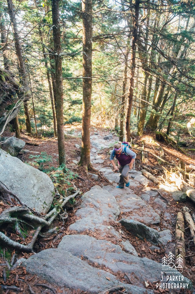
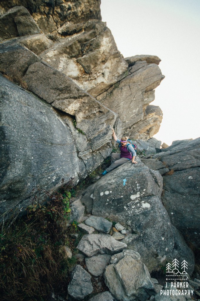
I knew the ascent would involve ladders and cables, and part of me was looking forward to just getting on with that portion of the whole ordeal, so I was excited when I spotted the first cabled section of trail awaiting on that steep ascent. There was nothing all that difficult looking about that cable as I gazed from below, in fact, I thought this would probably me easier than how we had been ascending before getting there. As I began to pull myself up, I marveled at the ease of going uphill.
“It’s really easy with the cable”, I remarked, naively, for I could not see where the cable was leading.
“Well, it gets harder up here” was my next statement as I reached the rock sloped rock slab I – and Jess – both of us with packs, would have to pull myself up and over, somehow not sliding off the edge in the process. I pondered our options briefly. We could turn around, satisfied that we had at least seen why Grandfather was such a unique hike, even if we hadn’t made it all the way to the top of McRae peak. Or we could risk all to experience an additional mile of trail, possibly getting another noteworthy scenic view on a trip where we had experienced one or more a day for almost a week, only risking death in the process.
I turned around before Jess even started the cable passage. There was no doubt in mind that in the shape we were in it was unsafe for either one of us to attempt this. We both had packs far too heavy for the physical obstacle presented, and our bodies were running on fumes in the high altitude after days of hiking on end, battered and bruised from navigating other rugged sections of trail like at Linville Gorge. I wasn’t that far from the end of our trip, and I already had pictures the likes of which I had never taken before, of waterfalls and fall color like I’d never been able to experience. I had seen sights and had stories to tell about them that I couldn’t wait to share. Just a week ago we started northward from Florida with over a weeks worth of hiking planned, not knowing if my questionable hip would let me complete any of them. On top of that I had started the trip sick, and spent moments slumped over a table, wondering if I had the strength to keep going. Despite those looming questions, we had seen countless breathtaking things – Tallulah Gorge, Dupont State Forest, Black Balsam, Linville Gorge, Rough Ridge, and others. I had a great compulsion to share these moments with others, and I knew dying was going to complicate those matters greatly (plus we had no money set aside for a funeral). I decided before we hiked Grandfather that we needed to get home safely so I wouldn’t tarnish all the definitive life moments we had experienced up to that point. We weren’t going to let a malevolent Grandfather ruin that; we were turning around, and we were going to have no shame or regrets about it.
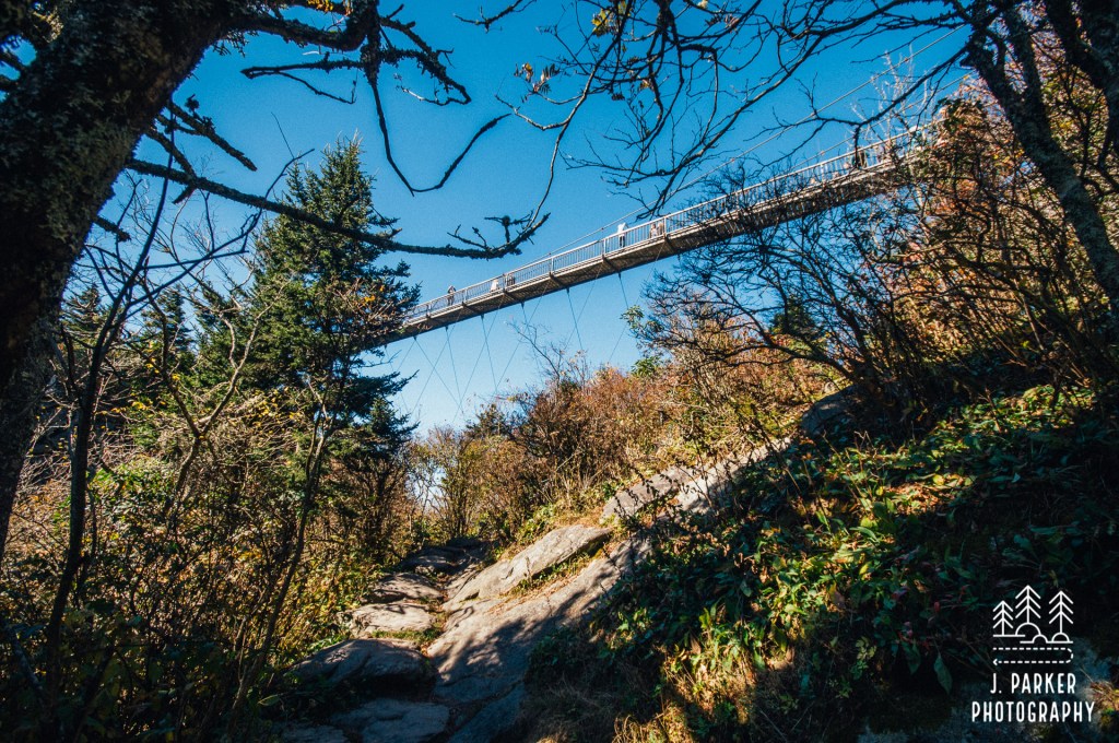
Grandfather still got the last laugh by making sure we both left with turned ankles; mine at the start, Jess while navigating that complicated rock scramble which we had already ventured across once. Retracing your steps is frequently easier than the outbound trip, but going downhill through a hellish rockscape like Grandfather was even more tough, and it was a laborious mile back to the parking area. Still, batted as we were, or perhaps because we were gluttons for punishment, we found the strength to hit a little bit of extra trail on the opposite side of the parking area so we could see the swinging bridge from below. As the parking lot at the top closest to the bridge fills up quickly, many use this trail to reach the bridge. Not us. We endured the uphill ascent right up to the moment till we caught a glimpse of the bridge, at which point I snapped a picture and was heading down the trail almost before my shutter had finished clicking. After the challenge we had endured, and with the fatigue we both felt, we were ready to leave Grandfather Mountain behind us as quick as possible. Well, maybe not THAT quick.
We still had to get a bite to eat before we left, both enjoying a cheeseburger at the park restaurant. But after that, totally ready to leave. Roan Mountain was waiting.

Wonderful write up and photography. Sharing with relatives who visit Avery County coming from Sarasota, Beaufort, Greenville, Columbia, Hampton Roads, Asheville, Lewisville, New York, Raleigh, Fuquay-Varina.
LikeLike